TellicoWx
-
Posts
2,632 -
Joined
-
Last visited
Content Type
Profiles
Blogs
Forums
American Weather
Media Demo
Store
Gallery
Everything posted by TellicoWx
-
Dandridge Dollop 12/24/20 Storm Thread (Winter Wonderland)
TellicoWx replied to AMZ8990's topic in Tennessee Valley
Not sure I have ever been NAM'd on the GEFs before...but #16 tried it's best lol- 847 replies
-
- 1
-

-
- cold temperatures
- snow
- (and 8 more)
-
Dandridge Dollop 12/24/20 Storm Thread (Winter Wonderland)
TellicoWx replied to AMZ8990's topic in Tennessee Valley
Individual members...some doozies in there- 847 replies
-
- 6
-

-

-
- cold temperatures
- snow
- (and 8 more)
-
Dandridge Dollop 12/24/20 Storm Thread (Winter Wonderland)
TellicoWx replied to AMZ8990's topic in Tennessee Valley
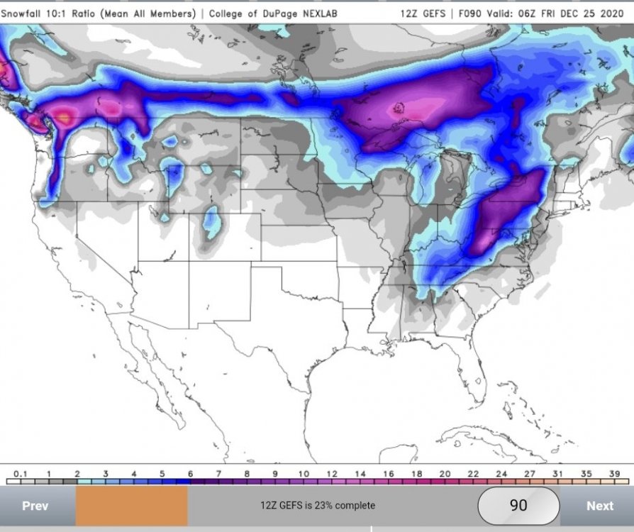
0z GEFS
- 847 replies
-
- 3
-
-
- cold temperatures
- snow
- (and 8 more)
-
Dandridge Dollop 12/24/20 Storm Thread (Winter Wonderland)
TellicoWx replied to AMZ8990's topic in Tennessee Valley
Purple back on the GEFS, maybe best run of it yet -
Dandridge Dollop 12/24/20 Storm Thread (Winter Wonderland)
TellicoWx replied to AMZ8990's topic in Tennessee Valley
0z GEFs already pulling the 2" mean back into NW AL -
Dandridge Dollop 12/24/20 Storm Thread (Winter Wonderland)
TellicoWx replied to AMZ8990's topic in Tennessee Valley
Goal posts are narrowing on where to pop the low...with 18z Euro close to where 0z GFS did. NAM may be doing it's thing of over amping too soon with the AL solution.- 847 replies
-
- 2
-
-
- cold temperatures
- snow
- (and 8 more)
-
Dandridge Dollop 12/24/20 Storm Thread (Winter Wonderland)
TellicoWx replied to AMZ8990's topic in Tennessee Valley
Yeah, good trends on all the OP's so far..3/3 on digging trough more- 847 replies
-
- 3
-
-
- cold temperatures
- snow
- (and 8 more)
-
Dandridge Dollop 12/24/20 Storm Thread (Winter Wonderland)
TellicoWx replied to AMZ8990's topic in Tennessee Valley
00z GFS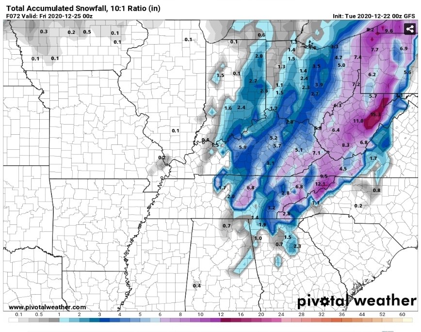
- 847 replies
-
- 3
-
-
- cold temperatures
- snow
- (and 8 more)
-
Dandridge Dollop 12/24/20 Storm Thread (Winter Wonderland)
TellicoWx replied to AMZ8990's topic in Tennessee Valley
Pops low NC/VA/TN line -
Dandridge Dollop 12/24/20 Storm Thread (Winter Wonderland)
TellicoWx replied to AMZ8990's topic in Tennessee Valley
Goofy trying to dig a little more -
Dandridge Dollop 12/24/20 Storm Thread (Winter Wonderland)
TellicoWx replied to AMZ8990's topic in Tennessee Valley
0z RGEM- 847 replies
-
- 1
-
-
- cold temperatures
- snow
- (and 8 more)
-
Dandridge Dollop 12/24/20 Storm Thread (Winter Wonderland)
TellicoWx replied to AMZ8990's topic in Tennessee Valley
0z RGEM popping the low over Sevier Co...gonna be a good run- 847 replies
-
- 1
-
-
- cold temperatures
- snow
- (and 8 more)
-
Dandridge Dollop 12/24/20 Storm Thread (Winter Wonderland)
TellicoWx replied to AMZ8990's topic in Tennessee Valley
0z RGEM digging the trough a little more as well- 847 replies
-
- 1
-
-
- cold temperatures
- snow
- (and 8 more)
-
Dandridge Dollop 12/24/20 Storm Thread (Winter Wonderland)
TellicoWx replied to AMZ8990's topic in Tennessee Valley
NAM dug the trough more at H5..and generated the low...an outlier right now, but with the continued snow showers behind it, think the precip shield/totals would be a little higher in that scenario- 847 replies
-
- 2
-
-
- cold temperatures
- snow
- (and 8 more)
-
Dandridge Dollop 12/24/20 Storm Thread (Winter Wonderland)
TellicoWx replied to AMZ8990's topic in Tennessee Valley
0z NAM starts off with a twist...forms Low over AL...runs it up the eastern valley- 847 replies
-
- 1
-
-
- cold temperatures
- snow
- (and 8 more)
-
Dandridge Dollop 12/24/20 Storm Thread (Winter Wonderland)
TellicoWx replied to AMZ8990's topic in Tennessee Valley
That looks about like middle ground right now...north end = WV, south end = NC/GA/SC border- 847 replies
-
- 2
-
-
- cold temperatures
- snow
- (and 8 more)
-
Dandridge Dollop 12/24/20 Storm Thread (Winter Wonderland)
TellicoWx replied to AMZ8990's topic in Tennessee Valley
Another one that comes to mind is a few years back that affected areas east of 75 -
Dandridge Dollop 12/24/20 Storm Thread (Winter Wonderland)
TellicoWx replied to AMZ8990's topic in Tennessee Valley
This line from MRX in the afternoon AFD pretty much sums up the mood the model OP runs have lol I`m still not ready to discuss accumulation numbers at this point- 847 replies
-
- 7
-
-
-
- cold temperatures
- snow
- (and 8 more)
-
Dandridge Dollop 12/24/20 Storm Thread (Winter Wonderland)
TellicoWx replied to AMZ8990's topic in Tennessee Valley
Lol, wish I could...2"-3" in the central/southern valley would be an incredible win for Christmas- 847 replies
-
- 3
-
-
- cold temperatures
- snow
- (and 8 more)
-
December 2020 Medium/Long Term Pattern Discussion.
TellicoWx replied to John1122's topic in Tennessee Valley
Agree, that's showing a prevelant low road track and in best timing for climo...If Pacific cooperates just a little could be a memorable Jan -
Dandridge Dollop 12/24/20 Storm Thread (Winter Wonderland)
TellicoWx replied to AMZ8990's topic in Tennessee Valley
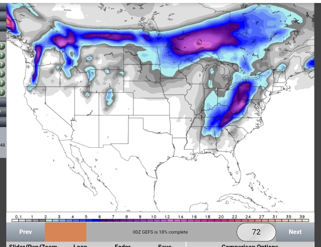
18z GEFS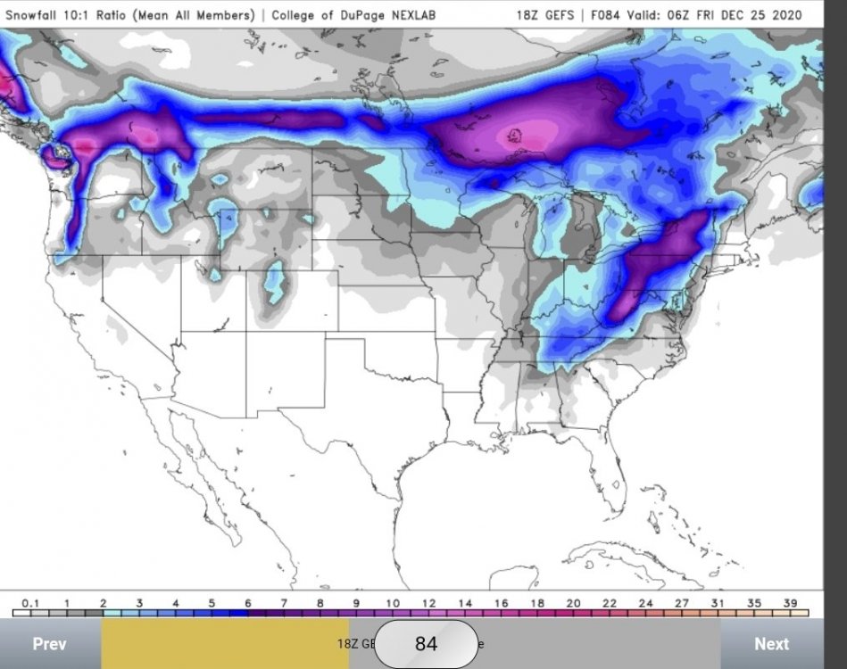
- 847 replies
-
- 2
-
-
- cold temperatures
- snow
- (and 8 more)
-
Dandridge Dollop 12/24/20 Storm Thread (Winter Wonderland)
TellicoWx replied to AMZ8990's topic in Tennessee Valley
18z GEFS pretty much stayed the same, but individual members look a lot better. Mean isn't skewed by a single member that had 16+ like 12z- 847 replies
-
- 5
-
-
- cold temperatures
- snow
- (and 8 more)
-
Dandridge Dollop 12/24/20 Storm Thread (Winter Wonderland)
TellicoWx replied to AMZ8990's topic in Tennessee Valley
Euro finally popping a surface low on the Lee side..just over WV. -
Dandridge Dollop 12/24/20 Storm Thread (Winter Wonderland)
TellicoWx replied to AMZ8990's topic in Tennessee Valley
UKie is la nada -
Dandridge Dollop 12/24/20 Storm Thread (Winter Wonderland)
TellicoWx replied to AMZ8990's topic in Tennessee Valley
GEFS has alot more uncertainty in it now..mean is skewed by a monster