TellicoWx
-
Posts
2,632 -
Joined
-
Last visited
Content Type
Profiles
Blogs
Forums
American Weather
Media Demo
Store
Gallery
Everything posted by TellicoWx
-
TN valley heavy rain/flooding week of whenever
TellicoWx replied to janetjanet998's topic in Tennessee Valley
That is a really scary radar for Knox Co. Line thru middle TN is on a ENE trajectory...not much of a north movement. Looks like the train will hit hardest I40 and N Knox Co. -
TN valley heavy rain/flooding week of whenever
TellicoWx replied to janetjanet998's topic in Tennessee Valley
Janet is correct...area flood warning was issued when a flash flood warning should have been first. Areal is for steady rises...which was not the case. -
TN valley heavy rain/flooding week of whenever
TellicoWx replied to janetjanet998's topic in Tennessee Valley
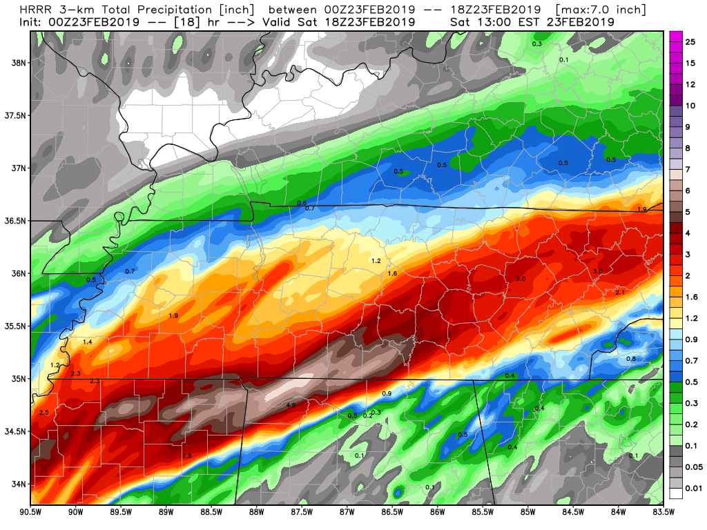
The recent radar trends have been favoring the heaviest axis of rainfall a bit to the south and east of the 00Z HREF mean including recent HRRR runs. Adjusting for this, and accounting for the organized nature of the convection (with aid of 50 to 60 kt effective bulk shear values), it would appear that the heaviest axis of rainfall going through the mid-morning hours will tend to be oriented more to the east-northeast from northern MS and northern AL over through south-central TN. Although, it appears that heavy rainfall with bit less intensity will also overspread eastern TN over the next several hours. Also, areas of far northwest GA and far southwest NC may see some period of heavy rain as well. The hires multi-model suite of guidance would support additional rainfall amounts as high as 2 to 4 inches with isolated amounts near 5 inches going through 15Z. -
TN valley heavy rain/flooding week of whenever
TellicoWx replied to janetjanet998's topic in Tennessee Valley
-
TN valley heavy rain/flooding week of whenever
TellicoWx replied to janetjanet998's topic in Tennessee Valley
Sometimes a pic is better than a model. This image of the SE radars tells alot. You can see the surface front drifting north over north central AL/GA, surging the moisture north (light blue shading near the radar sights south of the front. The 850 front drapped sw-ne across MS to the N Plateau. Where the surface front catches the 850 front...its unloading a tremendous amount of the gulf moisture. Very bad setup...anywhere N of the entire southern TN border..gif.104cd73640efec0e58823439a2f825b0.gif)
-
TN valley heavy rain/flooding week of whenever
TellicoWx replied to janetjanet998's topic in Tennessee Valley
Closed until at least sunrise...Geologist has to arrive. NCDOT Cam -
TN valley heavy rain/flooding week of whenever
TellicoWx replied to janetjanet998's topic in Tennessee Valley
4 pm, 3k. Still have the severe line of storms in W TN to go.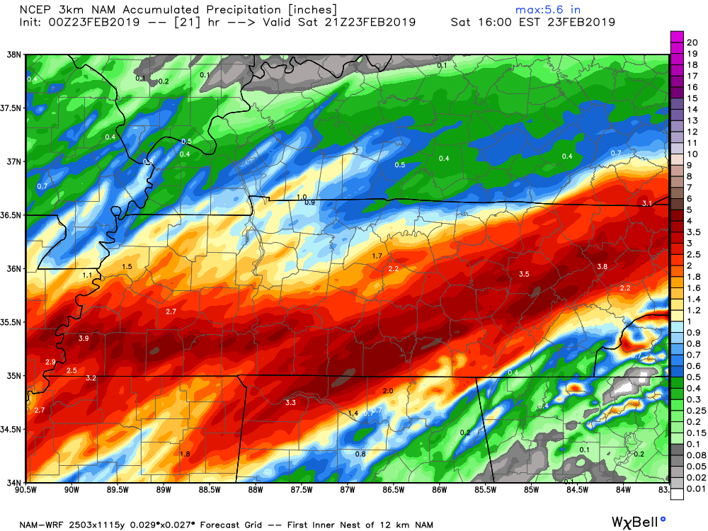
-
TN valley heavy rain/flooding week of whenever
TellicoWx replied to janetjanet998's topic in Tennessee Valley
Do you think the atmosphere can rebound that much after being worked over? -
TN valley heavy rain/flooding week of whenever
TellicoWx replied to janetjanet998's topic in Tennessee Valley
3k hammers southern border of TN/Plateau/into E TN...storms training same areas over and over -
TN valley heavy rain/flooding week of whenever
TellicoWx replied to janetjanet998's topic in Tennessee Valley
Wow...i feel for you guys put in W TN...flooding, then severe ramping up -
TN valley heavy rain/flooding week of whenever
TellicoWx replied to janetjanet998's topic in Tennessee Valley
00z NAM
-
TN valley heavy rain/flooding week of whenever
TellicoWx replied to janetjanet998's topic in Tennessee Valley
Fairly significant shift south on the 00z NAM as well. 18z was up into KY. -
TN valley heavy rain/flooding week of whenever
TellicoWx replied to janetjanet998's topic in Tennessee Valley
00z shifted south some on the HRRR...i fear some have let their guard down too soon (including myself).
-
TN valley heavy rain/flooding week of whenever
TellicoWx replied to janetjanet998's topic in Tennessee Valley
I'm not sure what is going wrong in the models (whether its something in the coding..etc), but even the initializations are off on the hi res short range. We have seen it all winter in the med to long range models. Perfect example of the chaos theory in action...bad initialization = compounded variation in error as time goes. -
TN valley heavy rain/flooding week of whenever
TellicoWx replied to janetjanet998's topic in Tennessee Valley
Outstanding job by the lock operators along Ft. Loudon lake. Tellico River has yet to reach Flood Stage. If someone had told me at the beggining we would be sitting at 6.3" by Friday morning and the river wouldn't flood, I would have thought they were silly. -
TN valley heavy rain/flooding week of whenever
TellicoWx replied to janetjanet998's topic in Tennessee Valley
1.26" so far and still moderate rain -
TN valley heavy rain/flooding week of whenever
TellicoWx replied to janetjanet998's topic in Tennessee Valley
00z 3k is prob worst case scenario for SE TN. Models all day have underperformed here... .6" so far. 3k spits out close to 3" by noon tomorrow and front still stalled south of the area, overrunning precip. -
TN valley heavy rain/flooding week of whenever
TellicoWx replied to janetjanet998's topic in Tennessee Valley
MRX: -
TN valley heavy rain/flooding week of whenever
TellicoWx replied to janetjanet998's topic in Tennessee Valley
Update to MRX FFW for E TN: * Additional periods of moderate to heavy rainfall will overspread the region tonight, lasting through Saturday morning. Rainfall totals ranging from 2 to 3 inches are expected with isolated higher amounts closer to 4 inches possible. * Given the already saturated soil and high stream flows, the additional moderate to heavy rains will likely cause significant stream flooding, roadway flooding, mud slides, and main stem river flooding. Potentiallly life threatening flooding is possible. * If you live near a stream, creek or river that typically floods easily, please have a plan in place now to evacuate in the event of flood waters begin to rise. -
TN valley heavy rain/flooding week of whenever
TellicoWx replied to janetjanet998's topic in Tennessee Valley
MRX now updated the Watch -
TN valley heavy rain/flooding week of whenever
TellicoWx replied to janetjanet998's topic in Tennessee Valley
Alabama Power opening flood gates now along the Coosa. People coming to the spillways to film and take pictures. -
TN valley heavy rain/flooding week of whenever
TellicoWx replied to janetjanet998's topic in Tennessee Valley
Coosa River in Rome, GA close to topping its banks and spilling into the city. -
TN valley heavy rain/flooding week of whenever
TellicoWx replied to janetjanet998's topic in Tennessee Valley
They went into HUN area as well, from reading the AFD, I believe they are trying to reach as many as possible regardless of CWA. -
TN valley heavy rain/flooding week of whenever
TellicoWx replied to janetjanet998's topic in Tennessee Valley
From OHX: -
TN valley heavy rain/flooding week of whenever
TellicoWx replied to janetjanet998's topic in Tennessee Valley
From OHX AFD, just wow...not too many times seen one wrote like this This isn`t a forecast discussion I write lightly. After yesterday`s widespread flooding across all of Middle TN, even with the 18 hour break in rainfall, the addition of even another 1 to 1.5 inches is going to create some major issues. The problem is, we`re now forecasting 1 to 3 inches of rain just through tomorrow afternoon and a total of 3 to 5 inches from tonight through Saturday night. The highest amounts are currently thought to fall across southwest portions of Middle TN, basically west of I-24 and south of I-40. While there were already swift water rescues yesterday, this amount of rainfall is likely to cause more of the same and probably even cause some people to be thinking about a plan to evacuate. This needs to be your focus prior tonight. If you live near a stream or a creek or a river that you know floods easily, you need to have a plan in place to evacuate and get to higher ground in the event waters begin to rise as this has the makings of a life-threatening situation. The main time of concern begins early tomorrow morning, runs right through most of the day tomorrow and probably won`t let up much, if at all, tomorrow night. While there is a severe weather threat Saturday evening across the mid-state, the focus right now needs to be the extreme amount of rainfall we`re expecting. Please don`t take this lightly. Have a plan in place now so you can evacuate to higher ground quickly, if need be.