TellicoWx
-
Posts
2,632 -
Joined
-
Last visited
Content Type
Profiles
Blogs
Forums
American Weather
Media Demo
Store
Gallery
Everything posted by TellicoWx
-
Yeah, I got the counties crossed. 00z backed off. With the main low trending further north, the threat is lessening some.
-
By no means am I saying this is how it will play out, but it is a little unnerving the date of the analogs on the 18z NAM. April 1998 was the F5 in Davidson Co.
-
TN valley heavy rain/flooding week of whenever
TellicoWx replied to janetjanet998's topic in Tennessee Valley
Flash Flood Watch for Whitley Co due to a possible dam about to fail: Including the cities of Corbin and Williamsburg 351 PM EST Mon Mar 4 2019 ...FLASH FLOOD WATCH IN EFFECT THROUGH TUESDAY AFTERNOON... The National Weather Service in Jackson has issued a * Flash Flood Watch for a portion of south central Kentucky, including the following area, Whitley. * Through Tuesday afternoon * Recent heavy rains have led to the strong potential of a dam failure on a dam on located along Corinth road in the Little Spruce Creek drainage about 2 miles southwest of Woodbine. * If the dam were to completely fail, flash flooding is expected for a couple of miles downstream of the dam. -
TN valley heavy rain/flooding week of whenever
TellicoWx replied to janetjanet998's topic in Tennessee Valley
Almost time to breakout the purples again unfortunately...12z GEFS -
TN valley heavy rain/flooding week of whenever
TellicoWx replied to janetjanet998's topic in Tennessee Valley
Will bust a little higher than most modeling (way higher than MRX/local forecasts). Most areas between Huntsville and southern Mid TN picked up around 1.5" -
TN valley heavy rain/flooding week of whenever
TellicoWx replied to janetjanet998's topic in Tennessee Valley
Yeah, GEFS has been putting a bullseye across parts of the upper/mid south for a couple days now...EURO has too, but with a little lesser amounts. -
TN valley heavy rain/flooding week of whenever
TellicoWx replied to janetjanet998's topic in Tennessee Valley
Most of the bright returns over west TN is brightbanding. 3k was a little to slow and Euro a little too far south, but so far amounts in west TN are close to what GFS had. Big question is does the convection develop over central/southern AL robbing the moisture transport north. -
TN valley heavy rain/flooding week of whenever
TellicoWx replied to janetjanet998's topic in Tennessee Valley
Picked up 1.14" so far here and still pouring -
TN valley heavy rain/flooding week of whenever
TellicoWx replied to janetjanet998's topic in Tennessee Valley
Big jump N on the 18z NAM...hopefully on overcorrection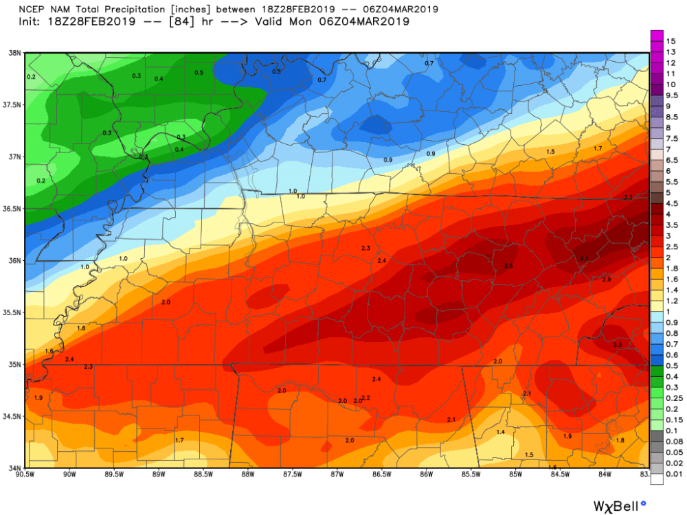
-
TN valley heavy rain/flooding week of whenever
TellicoWx replied to janetjanet998's topic in Tennessee Valley
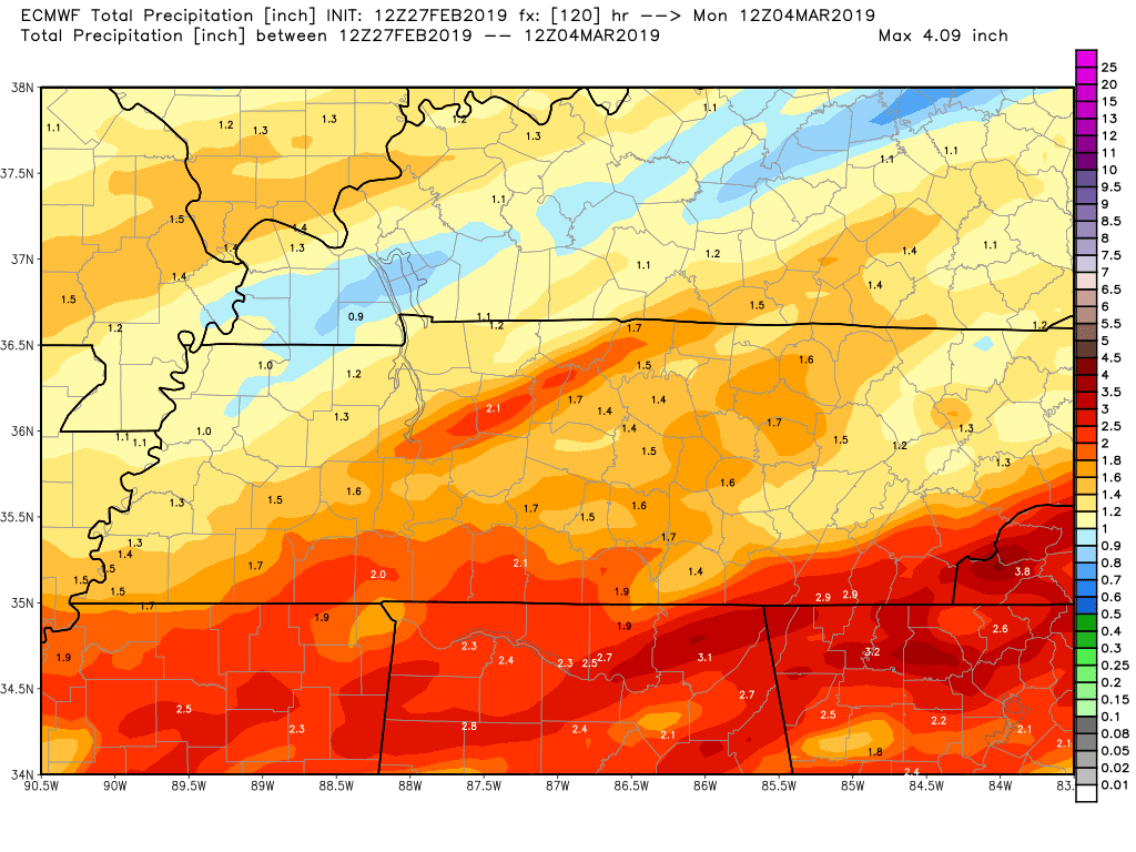
Definitely need to keep an eye on the weekend system across SE TN...Euro/NAM/CMC 12z suite showing 3"-5" across NW GA. GFS has similar range further south over Atlanta. -
TN valley heavy rain/flooding week of whenever
TellicoWx replied to janetjanet998's topic in Tennessee Valley
12z Euro
-
TN valley heavy rain/flooding week of whenever
TellicoWx replied to janetjanet998's topic in Tennessee Valley
Pic from Knox Mayor of a sinkhole just opened this morning in Powell -
TN valley heavy rain/flooding week of whenever
TellicoWx replied to janetjanet998's topic in Tennessee Valley
Reports of a landslide on Northshore Dr in Knoxville now -
TN valley heavy rain/flooding week of whenever
TellicoWx replied to janetjanet998's topic in Tennessee Valley
Don't believe snow is happening south of 40. Models have overplayed the reach of cold all winter, don't think this is any different. Region hopefully doesn't end up of the battle zone with stalled fronts. Much more of a NW shift on modeling and even the Cumberland region will be in the axis with these next waves. -
TN valley heavy rain/flooding week of whenever
TellicoWx replied to janetjanet998's topic in Tennessee Valley
EURO keeps shifting the axis of heaviest precip more N...something to keep an eye on over next 72 hrs. -
TN valley heavy rain/flooding week of whenever
TellicoWx replied to janetjanet998's topic in Tennessee Valley
No slides on anywhere here, unless it's in the CNF itself, off the roadways. Really has surprised me so far. -
TN valley heavy rain/flooding week of whenever
TellicoWx replied to janetjanet998's topic in Tennessee Valley
Overall, it was the 64th highest recording. SE TN mountains were spared the worst part. -
TN valley heavy rain/flooding week of whenever
TellicoWx replied to janetjanet998's topic in Tennessee Valley
Broke the daily flow record here on the Tellico, prev record was 1962. -
TN valley heavy rain/flooding week of whenever
TellicoWx replied to janetjanet998's topic in Tennessee Valley
That's my biggest concern here...heaviest rate look aimed more south of 40. River here didn't get to recede much and is right at bank full...need the stuff over N Al to weaken. -
TN valley heavy rain/flooding week of whenever
TellicoWx replied to janetjanet998's topic in Tennessee Valley
Columbus, MS just took a direct hit -
Widespread damage inside the city...scary video coming in from inside what appears to be a gas station.
-
Initial reports are Columbus took a direct hit
-
TN valley heavy rain/flooding week of whenever
TellicoWx replied to janetjanet998's topic in Tennessee Valley
EAS activated: -
TN valley heavy rain/flooding week of whenever
TellicoWx replied to janetjanet998's topic in Tennessee Valley
Exit 49 on I75 in McMinn Co is closed. Hwy 305 is becoming impassable in places. AFD Pics: -
TN valley heavy rain/flooding week of whenever
TellicoWx replied to janetjanet998's topic in Tennessee Valley
Flash Flood Warning for Roane and Loudon Co now