TellicoWx
-
Posts
2,632 -
Joined
-
Last visited
Content Type
Profiles
Blogs
Forums
American Weather
Media Demo
Store
Gallery
Everything posted by TellicoWx
-
TN valley heavy rain/flooding week of whenever
TellicoWx replied to janetjanet998's topic in Tennessee Valley
HRRR is initializing too low even for the rain here in the last hour. Doesn't have an accumulation until after midnight, picked up .23". -
TN valley heavy rain/flooding week of whenever
TellicoWx replied to janetjanet998's topic in Tennessee Valley
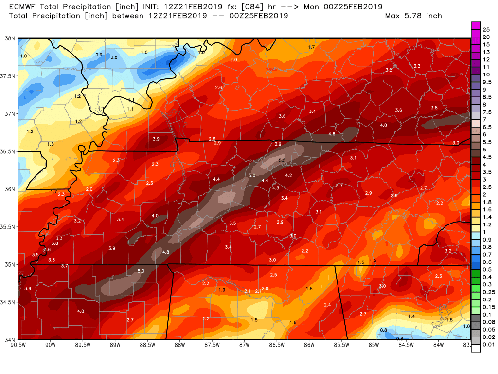
12z Euro:
-
TN valley heavy rain/flooding week of whenever
TellicoWx replied to janetjanet998's topic in Tennessee Valley
321 closed again...another slide between Walland and Townsend -
TN valley heavy rain/flooding week of whenever
TellicoWx replied to janetjanet998's topic in Tennessee Valley
Day 2 WPC FFG: Yet another impulse in the mid levels moving northward from the Gulf of Mexico will move across portions of Mississippi and Louisiana at the start of the Day 2 period...or Friday morning...and then take a more easterly track by the time is reaches the southern portion of the Appalachians. Heaviest rainfall from the system looks in the Tennessee Valey and portions of adjacent states. Model QPF values were generally in the 2 to 3 inch range with a couple isolated amounts in excess of 4 inches. This is consistent with some instability developing in response to deepening moisture, low level flow on the order of 25 kts to 35 kts that accelerates to between 30 kts and 45 kts as well as weakly channeled mid level vorticity. The synoptic set up and the QPF amounts would not garner much attention if the conditions had been dry...but the area has had multiple rounds of moderate to heavy rainfall over the past 5 days or so and Flash Flood Guidance values have been supressed accordingly. Maximum rainfall on Day 2 is expected to be in the Tennessee Valley and Southern States...but flash flooding is a concern in the southern portion of the Appalachians. Rain will be falling in complex terrain and in areas of snow-cover...making the area more vulnerable to flash flooding despite the fact that heaviest rainfall stays to the west. Based on coordination/collaboration with affected offices, have introduced a Moderate Risk of Excessive Rainfall over portions of the Tennesse Valley on Day 2. -
TN valley heavy rain/flooding week of whenever
TellicoWx replied to janetjanet998's topic in Tennessee Valley
Hwy 70 in Hawkins Co...Pic TDOT. Homes evacuated within 1/2 mile radius and TDOT geologist now on site. Incredible wasn't more hurt due to being during overnight hours. -
TN valley heavy rain/flooding week of whenever
TellicoWx replied to janetjanet998's topic in Tennessee Valley
Enhanced Severe risk now for weekend: In phase with the subtropical westerlies, a vigorous short wave impulse of mid-latitude Pacific origins is forecast to accelerate northeast of the southern Plains through the Great Lakes region during this period. Strong cyclogenesis may already be underway by 12Z Saturday near the Texas/Oklahoma Panhandle vicinity, and models continue to indicate that the rapid evolution of a broad and deep cyclone will proceed northeastward into the Great Lakes region by the end of the period. This likely will include the intensification of a cyclonic mid-level jet, including speeds in excess of 100 kt at 500 mb, across the southern Plains Red River Valley, through the middle Mississippi and Ohio Valleys. Across the evolving warm sector, models indicate that south/southwesterly winds will strengthen to 50-70+ kt through the 850-700 mb layer. Although the warm frontal zone probably will surge north of the Ohio River, and into/through the lower Great Lakes region by late Saturday evening, an initial position roughly along the Ohio River west-southwestward into the Ozark Plateau may provide the main focus for severe thunderstorm potential. Early period convection, associated with weak elevated destabilization above the front, may inhibit, or at least slow, boundary-layer destabilization to the north, while leaving a remnant surface boundary. In association with the onset of stronger surface pressure falls, surface dew points are expected to increase through the lower/mid 60s along and south of this boundary. Coupled with strengthening large-scale ascent, this is expected to contribute at least weak boundary-layer destabilization supportive of an evolving organized mesoscale convective system. CAPE on the order of 500+ J/kg appears possible. Given the strength of the environmental wind fields (and shear) within the convective layer, the convective system may be accompanied by considerable potential for strong and damaging wind gusts. It appears that this may initiate over parts of central and eastern Arkansas by midday, before progressing east-northeastward through the lower Ohio Valley by Saturday evening. A few tornadoes, some strong, are also possible, particularly with discrete supercells which may form near/just ahead of mainly the southern flank of the evolving system. More discrete storms, including supercells, may eventually develop as far south as the lower Mississippi Valley through portions of the southern Appalachians by late Saturday night. -
TN valley heavy rain/flooding week of whenever
TellicoWx replied to janetjanet998's topic in Tennessee Valley
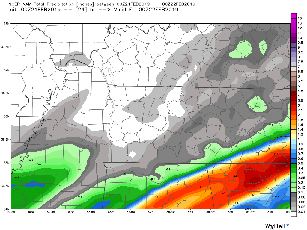
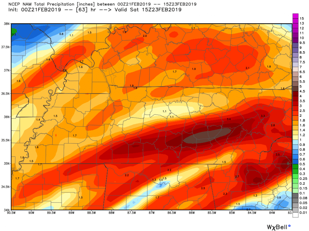
00z suite: basically all hi res short range model (NAM/3K/RGEM/HRRR) plus CMC (2-4 for southern M TN & C/S Valley) vs GFS/FV3/ICON (further NW & lighter) thru Fri evening. -
TN valley heavy rain/flooding week of whenever
TellicoWx replied to janetjanet998's topic in Tennessee Valley
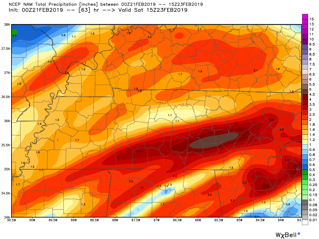
3k NAM very similar, trains storms over the same area Fri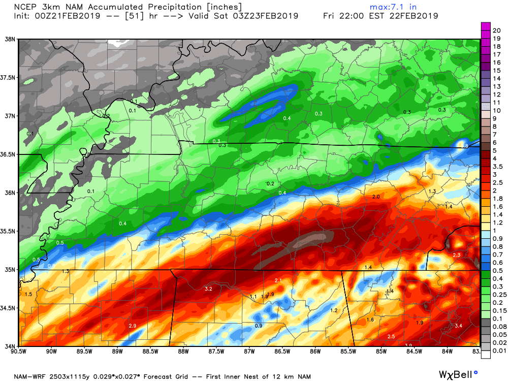
-
TN valley heavy rain/flooding week of whenever
TellicoWx replied to janetjanet998's topic in Tennessee Valley
00z NAM is ugly Friday for southern TN and central valley. Front doesn't push as quickly north and stalls, before pushing thru. Tomorrow the front is stalled a little too close for comfort across SE TN...N GA gets hammered.
-
TN valley heavy rain/flooding week of whenever
TellicoWx replied to janetjanet998's topic in Tennessee Valley
Def looks like glitches data on those wind speed. The gust (green), should always be above or inline with wind speed (red) -
TN valley heavy rain/flooding week of whenever
TellicoWx replied to janetjanet998's topic in Tennessee Valley
Not a good warning map this morning in Middle TN -
TN valley heavy rain/flooding week of whenever
TellicoWx replied to janetjanet998's topic in Tennessee Valley
Bad situation in Davidson Co and surrounding areas...overlapping FFW in that area. -
TN valley heavy rain/flooding week of whenever
TellicoWx replied to janetjanet998's topic in Tennessee Valley
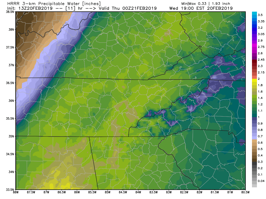
Starting to become a little more concerned this afternoon and overnight for the central and southern valley. Risk of flash flooding from torrential rain and training is increasing on the hi res models. PWAT values are near 1.6+ coming up the valley now, with storms training over the area. Unlike the past couple waves involving a large rain shield, 1.5+ is being produced over a very short time. 12z 3k and HRRR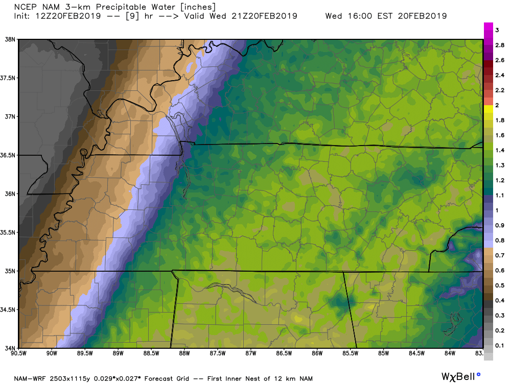

-
TN valley heavy rain/flooding week of whenever
TellicoWx replied to janetjanet998's topic in Tennessee Valley
Town has lost power now...numerous outages county wide -
TN valley heavy rain/flooding week of whenever
TellicoWx replied to janetjanet998's topic in Tennessee Valley
Already have 73 customers out here in the southern part of Monroe Co. -
TN valley heavy rain/flooding week of whenever
TellicoWx replied to janetjanet998's topic in Tennessee Valley
Wind has begun to pick up here as well...temp shot up to 50 -
TN valley heavy rain/flooding week of whenever
TellicoWx replied to janetjanet998's topic in Tennessee Valley
Concerning...Heavy rainfall...Flash flooding possible Valid 200353Z - 200953Z Summary...An uptick in moderate to heavy showers and thunderstorms overnight, with the potential for repeating rounds, will raise the risk of flash flooding across portions of the mid-MS, TN, and lower OH Valleys. Discussion...Deep mid/upper level trough over the Southwest US and +140 kt jet downstream has put the lower/mid MS, TN, and lower OH River Valleys well within the favorable right entrance region this evening. Southerly flow in the low levels is surging higher moisture northward, characterized by an increase in PWs, now ranging from 1.2 to 1.4" per latest TPW blends and RAP mesoanalysis. Regional radar imagery shows plenty of elevated showers and thunderstorms ongoing from the Arklatex region northeastward toward the confluence of the OH and MS Rivers with a noted cooling in the IR imagery cloud tops. This is supported by the RAP analysis of 500-1500 J/kg of MUCAPE as far north as the TN/KY border. Over the next several hours, the low level jet is expected to increase with 850 mb winds forecast between 50-70 kts by 07-08z. This should act to further surge the anomalously high PWs (2-3 SD above the mean) northward. Convection should continue to blossom over the region and with the expected storm motion (southwest to northeast) closely aligned with the mean flow, repeating rounds and training will be possible. Hi-res models indicate that through about 10z, a swath of 1-2" with local amounts near 3", will be possible from central/eastern AR, western TN, northern MS, and southwest KY. This region has been running very wet the last 14 days (300-400 percent of normal) so the additional rainfall combined with colder ground surfaces will lead to enhanced runoff and potential flash flooding. -
TN valley heavy rain/flooding week of whenever
TellicoWx replied to janetjanet998's topic in Tennessee Valley
00z GFS came in a lot drier between 12z Wed- 12z Thur for the E TN valley...still a big threat for the plateau and west. -
TN valley heavy rain/flooding week of whenever
TellicoWx replied to janetjanet998's topic in Tennessee Valley
MRX with a Flood Advisory for the entire CWA now -
TN valley heavy rain/flooding week of whenever
TellicoWx replied to janetjanet998's topic in Tennessee Valley
Flood Advisory for the southern 1/3 of the E TN valley now -
TN valley heavy rain/flooding week of whenever
TellicoWx replied to janetjanet998's topic in Tennessee Valley
Photo courtesy WPVFD...small section of the shoulder on Hwy 30 has slide off -
TN valley heavy rain/flooding week of whenever
TellicoWx replied to janetjanet998's topic in Tennessee Valley
Trying to get more info, but per West Polk FD...A section of westbound Hwy 30 in Polk Co is closed..either due to a slide or a section of the road collapsed. -
TN valley heavy rain/flooding week of whenever
TellicoWx replied to janetjanet998's topic in Tennessee Valley
Hwy 321 is closed again at the Kinzel Springs rockslide -
TN valley heavy rain/flooding week of whenever
TellicoWx replied to janetjanet998's topic in Tennessee Valley
Delta Flight from Milwaukee struck by lightning and made emergency landing at Chattanooga airport. -
TN valley heavy rain/flooding week of whenever
TellicoWx replied to janetjanet998's topic in Tennessee Valley
From GSP Twitter page, Newfound Gap. Can't help but wonder how this may actually increase the slide potential across the higher elevations once the warm are pushes thru and unthaws the ground.