ILoveWinter
-
Posts
1,458 -
Joined
-
Last visited
Content Type
Profiles
Blogs
Forums
American Weather
Media Demo
Store
Gallery
Everything posted by ILoveWinter
-
4-8 in the immediate NYC metro would be amazing considering the garbage we've experience in the past few years but yes in the wider context I agree.
-
I'm no expert but I wouldn't say the models are not credible now, only that both the passage of time and tonights storm will of course make things clearer.
-
Yea we really should only be looking at ensemble means at this early juncture. No use getting overly excited or upset over Ops runs 5-6 days out, especially as we wait for the friday night storm to clear out before we get a better picture of the finer details.
-
How did EPS look? Prob better to look at ensembles vs any op run at this juncture
-
Two Mdt to high impact events NYC subforum; wknd Jan 6-7 Incl OBS, and mid week Jan 9-10 (incl OBS). Total water equiv by 00z/11 general 2", possibly 6" includes snow-ice mainly interior. RVR flood potential increases Jan 10 and beyond. Damaging wind.
ILoveWinter replied to wdrag's topic in New York City Metro
Light to moderate snow in the UWS -
Two Mdt to high impact events NYC subforum; wknd Jan 6-7 Incl OBS, and mid week Jan 9-10 (incl OBS). Total water equiv by 00z/11 general 2", possibly 6" includes snow-ice mainly interior. RVR flood potential increases Jan 10 and beyond. Damaging wind.
ILoveWinter replied to wdrag's topic in New York City Metro
Moderate snow in the UWS but mostly wet and not white on surfaces -
Two Mdt to high impact events NYC subforum; wknd Jan 6-7 Incl OBS, and mid week Jan 9-10 (incl OBS). Total water equiv by 00z/11 general 2", possibly 6" includes snow-ice mainly interior. RVR flood potential increases Jan 10 and beyond. Damaging wind.
ILoveWinter replied to wdrag's topic in New York City Metro
Flurries in the UWS -
Two Mdt to high impact events NYC subforum; wknd Jan 6-7 Incl OBS, and mid week Jan 9-10 (incl OBS). Total water equiv by 00z/11 general 2", possibly 6" includes snow-ice mainly interior. RVR flood potential increases Jan 10 and beyond. Damaging wind.
ILoveWinter replied to wdrag's topic in New York City Metro
I'm still waiting for the inevitable "storm looks to be forming further east / colder than modeled!" posts lol- 3,610 replies
-
- 1
-

-
- snow
- heavy rain
- (and 5 more)
-
Two Mdt to high impact events NYC subforum; wknd Jan 6-7 Incl OBS, and mid week Jan 9-10 (incl OBS). Total water equiv by 00z/11 general 2", possibly 6" includes snow-ice mainly interior. RVR flood potential increases Jan 10 and beyond. Damaging wind.
ILoveWinter replied to wdrag's topic in New York City Metro
Agreed and as I've posted before, I live near the Park and recorded around 1.5 in multiple locations during one of the storms last year. Issue was that it didn't last long so they may have missed it.- 3,610 replies
-
- 1
-

-
- snow
- heavy rain
- (and 5 more)
-
Two Mdt to high impact events NYC subforum; wknd Jan 6-7 Incl OBS, and mid week Jan 9-10 (incl OBS). Total water equiv by 00z/11 general 2", possibly 6" includes snow-ice mainly interior. RVR flood potential increases Jan 10 and beyond. Damaging wind.
ILoveWinter replied to wdrag's topic in New York City Metro
Clearly things not looking good for the immediate Metro though I still hold out the possibility of a strong hour or two front end thump that could lead to an inch or so at the Park. -
Of course, it's a rain event lol
-
Two Mdt to high impact events NYC subforum; wknd Jan 6-7 Incl OBS, and mid week Jan 9-10 (incl OBS). Total water equiv by 00z/11 general 2", possibly 6" includes snow-ice mainly interior. RVR flood potential increases Jan 10 and beyond. Damaging wind.
ILoveWinter replied to wdrag's topic in New York City Metro
And it's wrong, I live near the Park and I measured 1.5-1.75 (multiple locations) during one of the storms last year.- 3,610 replies
-
- 1
-
-
- snow
- heavy rain
- (and 5 more)
-
Two Mdt to high impact events NYC subforum; wknd Jan 6-7 Incl OBS, and mid week Jan 9-10 (incl OBS). Total water equiv by 00z/11 general 2", possibly 6" includes snow-ice mainly interior. RVR flood potential increases Jan 10 and beyond. Damaging wind.
ILoveWinter replied to wdrag's topic in New York City Metro
Agree. After experiencing many winters in the City, BL temps just don't cut it here - unless there are strong dynamics / rates.- 3,610 replies
-
- 2
-
-
- snow
- heavy rain
- (and 5 more)
-
Two Mdt to high impact events NYC subforum; wknd Jan 6-7 Incl OBS, and mid week Jan 9-10 (incl OBS). Total water equiv by 00z/11 general 2", possibly 6" includes snow-ice mainly interior. RVR flood potential increases Jan 10 and beyond. Damaging wind.
ILoveWinter replied to wdrag's topic in New York City Metro
Good trends today - especially for those north and west but within the City itself, borderline temps will not cut it for anything but wet roads and some slushy accumulation on grass. Hopefully the trend continues. Taking this NAM run with a grain of salt though it's definitely pretty to look at! -
Two Mdt to high impact events NYC subforum; wknd Jan 6-7 Incl OBS, and mid week Jan 9-10 (incl OBS). Total water equiv by 00z/11 general 2", possibly 6" includes snow-ice mainly interior. RVR flood potential increases Jan 10 and beyond. Damaging wind.
ILoveWinter replied to wdrag's topic in New York City Metro
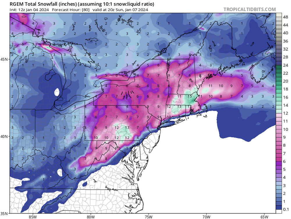
I was referring to this (yes ratios too high but this is not terrible for the immediate metro)
-
Two Mdt to high impact events NYC subforum; wknd Jan 6-7 Incl OBS, and mid week Jan 9-10 (incl OBS). Total water equiv by 00z/11 general 2", possibly 6" includes snow-ice mainly interior. RVR flood potential increases Jan 10 and beyond. Damaging wind.
ILoveWinter replied to wdrag's topic in New York City Metro
RGEM wasn't terrible for the coast but yes needs more support to be believable. Hopefully the Euro shows some improvement in less than an hour though it's prob a long shot. -
Two Mdt to high impact events NYC subforum; wknd Jan 6-7 Incl OBS, and mid week Jan 9-10 (incl OBS). Total water equiv by 00z/11 general 2", possibly 6" includes snow-ice mainly interior. RVR flood potential increases Jan 10 and beyond. Damaging wind.
ILoveWinter replied to wdrag's topic in New York City Metro
Also, won't this be mostly an overnight event? This certainly would help to accumulate a few inches within the city. -
Two Mdt to high impact events NYC subforum; wknd Jan 6-7 Incl OBS, and mid week Jan 9-10 (incl OBS). Total water equiv by 00z/11 general 2", possibly 6" includes snow-ice mainly interior. RVR flood potential increases Jan 10 and beyond. Damaging wind.
ILoveWinter replied to wdrag's topic in New York City Metro
Currently in Cancun and heading back tomorrow, nice surprise to see there is finally something to track! (it's been a few years maybe for me living in the city?). Would be great to see 3 or more inches. -
Yea this is my approach now, better for my snow loving sanity
-
lol, you were weenied for posting your temp!
-
Certainly frustrating that highs near 50 around Christmas needs to be qualified with a statement that it's "nothing too extreme compared to some recent years"!
-
looking at the radar, nothing substantial until at least early afternoon
-
It wouldn't be right if it didn't rain during the weekend. Another day with outdoor plans ruined, oh well.
-
It is for my kids!
-
Another weekend ruined, just awful.