Winter Wizard
-
Posts
671 -
Joined
-
Last visited
Content Type
Profiles
Blogs
Forums
American Weather
Media Demo
Store
Gallery
Everything posted by Winter Wizard
-

April 8th Eclipse- Last Easy One To See In My Lifetime
Winter Wizard replied to Interstate's topic in Mid Atlantic
I'll be in San Antonio for this. Would be nice to run into some of you folks down there. -
The Weekend Rule? Saturday 2/17 - The Icon Storm
Winter Wizard replied to DDweatherman's topic in Mid Atlantic
Temps are basically at freezing near the cities. Once you move toward mountains and the Mason-Dixon Line, different story. -
The Weekend Rule? Saturday 2/17 - The Icon Storm
Winter Wizard replied to DDweatherman's topic in Mid Atlantic
I think this looks good for another region wide advisory event, would put 2-4” as a starting point for most. Still room for a bit more upside, and I think we’ll see pockets of 6”+ near the Mason-Dixon Line. Perhaps a lite version of 1/19? I wouldn’t be surprised if there was a last second tick north but most should be immune from that. -
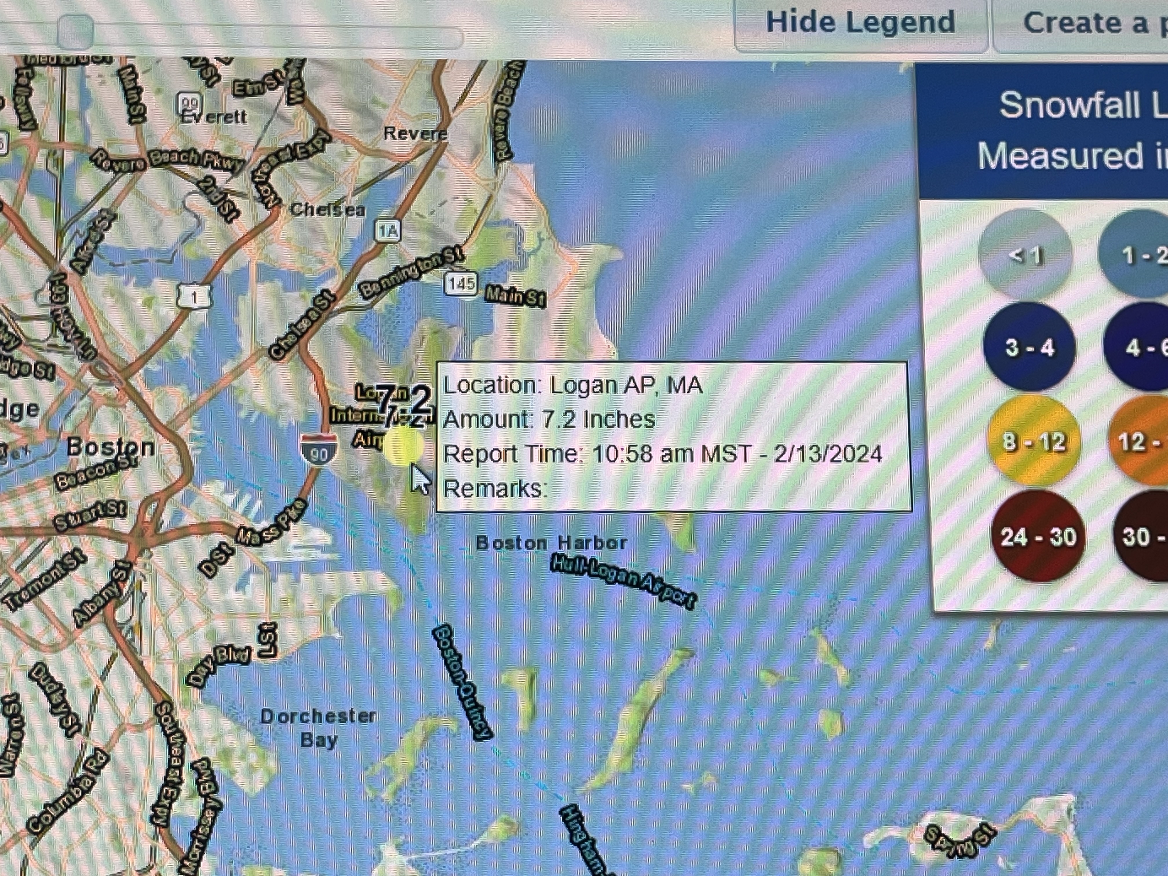
Nothing but white rain in Somerville.
-
HRRR and RAP are both trending toward the Euro clearly at 18z. Not just in terms of south, but in terms of withering away the dynamics. This one is slipping away.
-
I hate to say it, but there is a pathway for the Euro/UK to be right if the weakening trend continues. Trim back the dynamics of the storm, and it becomes harder to overcome a marginal airmass. Hard to bet against the majority of guidance in favor of an outlier, but this raises a red flag to me. Models seem to really be struggling with the convection. I'm holding the line for a significant snowstorm for all of SNE, but with more caution.
-
I agree with you on this one, this airmass is poor and I would keep expectations very low near the coast. I do think everyone will changeover at the end as colder air advects, but the question is, would that be too late for anything appreciable? It can work with a Euro like amped solution, but not so much if it's weaker like some of the other models.
-
This is one of the most thread the needle storms I've ever seen.
-
January 19, 2024 Powder Snow Event
Winter Wizard replied to Ralph Wiggum's topic in Philadelphia Region
I'm told we have between 4 and 5 inches at our house in Wilmington. I no longer live there, but nice to see the area finally get a WSW event. Haven't seen one there since March 2018. -
Jan 18-19 Storm Threat: Bob Chill made me do it
Winter Wizard replied to stormtracker's topic in Mid Atlantic
This storm ticks all the boxes you want…fresh injection of Arctic air and deepening vort passing to the south. I think it looks good for another moderate event forum wide with some room to go up. Consider me bullish.- 684 replies
-
- 23
-

-
Jan 15-16 Storm Threat Thread: The Return of Hope??
Winter Wizard replied to stormtracker's topic in Mid Atlantic
Looks good for area wide 2-4. Some could eke out a bit more depending on banding. -
Mixing issues near the coast otherwise Euro looked sweet for most people. Getting closer to locking in a nice hit.
-
The trailing vort over the Deep South tells the story here...it's more progressive, so the trough turns negative sooner, and that allows our storm to deepen further. The ceiling has been raised with this one.
-
Wow, that's a crusha.
-
Hour 108 looks pretty juicy too with the stronger storm just off the Cape. May open up the door for a longer duration event as this continues to throw moisture back toward the coast. Perhaps that could make up for a potential messy start?
-
Yep, exactly, all of those pieces are working in tandem which makes this complex. Putting it together, I think these are subtle but noticeable improvements across the board for most in this subforum.
-
Confluence is a bit weaker this run, I expect a tick back to the north. Also a little stronger.
-
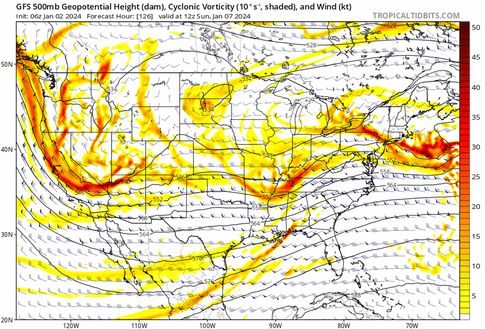
Two Mdt to high impact events NYC subforum; wknd Jan 6-7 Incl OBS, and mid week Jan 9-10 (incl OBS). Total water equiv by 00z/11 general 2", possibly 6" includes snow-ice mainly interior. RVR flood potential increases Jan 10 and beyond. Damaging wind.
Winter Wizard replied to wdrag's topic in New York City Metro
Nope. The low center is 2 mb weaker and a bit east, but the rain-snow line is more N and W. I reiterate what the other mets have said that this is very much thread the needle between conflicting variables. You need to simultaneously balance being amplified enough to send in the best dynamics and not be squashed by confluence, but also not torching the mid levels with strong easterly flow. Extremely difficult to pull off in this setup. Interior is a different story, this should be nice for the Poconos, NWNJ, and I-84 corridor in NY.- 3,610 replies
-
- 5
-
-
- snow
- heavy rain
- (and 5 more)
-
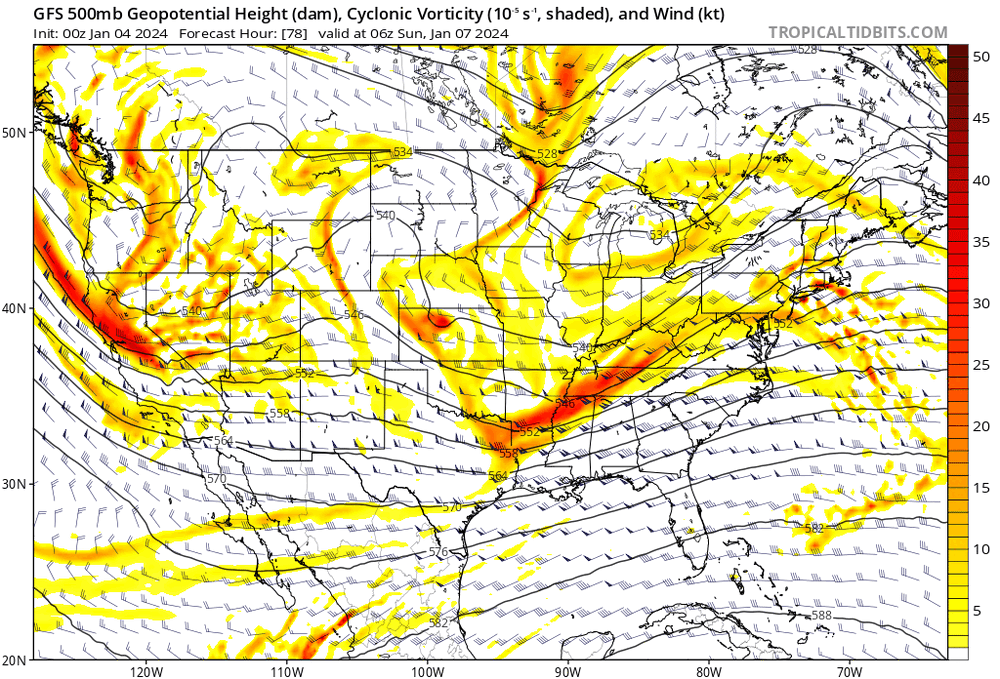
OH Valley primary low looks weaker and north and Canadian high retreating a bit sooner. Hour 102.
-
Two Mdt to high impact events NYC subforum; wknd Jan 6-7 Incl OBS, and mid week Jan 9-10 (incl OBS). Total water equiv by 00z/11 general 2", possibly 6" includes snow-ice mainly interior. RVR flood potential increases Jan 10 and beyond. Damaging wind.
Winter Wizard replied to wdrag's topic in New York City Metro
OH Valley primary low looks weaker and north and Canadian high retreating a bit sooner. Hour 102.- 3,610 replies
-
- 1
-
-
- snow
- heavy rain
- (and 5 more)
-
Agreed and at a certain point we have to be careful what we wish for. Unless there's a windshield wiper back, I think it's totally plausible for this to keep moving north and west to the point where perhaps BOS, PVD, and HFD are in danger of mixing. Curious to see what the ensembles and the Euro suite show, but I've been more concerned about an inland runner vs. suppression.
-
Two notable trends here: notably less confluence over Atlantic Canada and a less amplified western US trough.
-
Euro looks like deja vu from this week but with an even stronger storm. Deluge to heavy wet snow is certainly a plausible idea for the interior depending how the low occludes.
-
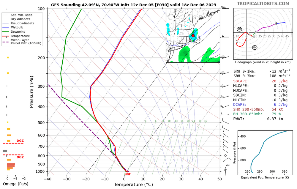
Don't think anyone on the outside is missing much. Marginal temperatures and snow growth looks poor. I think any accumulations on the South Shore would be pretty localized.