Search the Community
Showing results for tags 'becoming more likely'.
Found 1 result
-
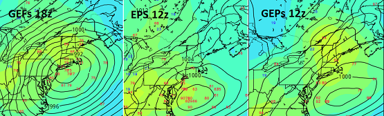
 Alright ... let's try a different tact this go around. There is an important signal for the dates in the title, one that I would characterize as a medium impact for now, with both higher and lower correction potential. Firstly, I realize the villagers are bit edgy if not incensed by the debacle that's gone on in the models, wrt the 28th system. I mean I get it. Unfortunately, nature is not going to wait for you to get over it. The language contained is not intended to sell cinema here. It's should be treated as an early awareness, outline some observations for consideration regarding the 3rd/4th event. Technically being inside of 7 days ... (5.5 or so days 18z, and this is in shotgun sites of our region ...), this is not an atypical range to preliminary a threat assessment. That is what this is for. It is important to compartmentalize these recent disappointments as being unrelated to this prospect - because simply put ... they are unrelated to this prospect. I will be happy to come in here and add the operative adjectives should this evolve in a clear and obvious d-drip direction.. --------------------------------------------------------------------------------------------------------------------------------------------- Basic synopsis: A deeper more expansive full latitude trough than has been observed in recent weeks if not months, appears slated to be ejected out of the semi permanent -PNA nadir over the SW... resulting ultimately in a fast moving QPF loaded Miller A type low genesis and track that brings it to our doorstep by the end of the 3rd. It is lifting N out of the Arklotext region, which climatologically that's brought flooding problems in springs, owing to proximity to warm inflow/Gulf of Mexico moisture source, resulting in an enormous PWAT transport. We have ample cold on the N side of this particular low. Presently modeled in both the Euro and GFS operational version ... a cryo sufficiently cold air mass is in place across PA/NY NE England, back built by +PP in Ontario, already as this system is modeled to approach. The cold side of risks a hefty amount of liq equiv in S/IP/ICE over perhaps a 12 to 18 hour period. Models: You are all aware of the 00z, 06z, 12z, and this recent 18z blends of the GFS ... but for the sake of discussion: monster in that particular guidance source. Negatively tilted with over a 100kts of massively loaded jet transport. The exit/lateral/entry regions of this thing are extraordinary, even as it is being force by the antecedent and on-going -PNA footprint, to open up a dish pan trough structure when it cross through - again...as GFS is arranging things. This is the most intense version of this system I can find, moving the low track over central LI to SE Ma ~ targeting deep interior for goodly dose of IP/ZR and snow W_N The Euro made a pretty significant correction N... having about half to 3/4 of the GFS amplitude, targeting DC to NJ for a significant snow event. Perhaps the most use/telling are the ensemble means... The GEFs seem to parrot the operational version, having an impressively large deep solution that varied from SE Ma to the Benchmark over the last several cycles. The EPS has made significant attempt toward more structure, as has the GEPs... Perhaps someone can post those images ? All these are improving over cycles, with the EPS and GEPs making a more convincing lurch today. They also have an interestingly varied spread in intensity, with some of them getting rather exotic - this I feel owes to the incredible diabatic inject this system has as a ( really ...) early spring, deeper latitude origin, riding N into a cold antecedent/seasonal latency in place in our region. Hence the high ceiling potential. The "super blend" of these is almost a perfect scenario ... but that's likely just a present artifact of noise. Caveats emptors and the lower ceiling potential: 1 .. the -PNA footprint is raging through next week, and March 4. System ejected out of the west will need to supply ( most likely...) there own mechanical power to overcome being lift over the negative (NVA) aspect of the SE ridge. 2 ..In reality, I suspect some de-magnification shit will occur. ...I don't believe the GFS is necessarily right with 20" in Albany and 3" of sleet and ZR from Kevin to myself... But, the blend of the GEFS/EPS/GEPs is trending to a much, much more deeper full troposphere ejection through the W. As comparison, that's a much different animal compared to the over-sell that took place with the 28th and is also the biggest mass modality we've seen perhaps since Dec.