

Winter Wizard
-
Posts
671 -
Joined
-
Last visited
Content Type
Profiles
Blogs
Forums
American Weather
Media Demo
Store
Gallery
Everything posted by Winter Wizard
-

12/14: Sunday funday? Will the south win again?
Winter Wizard replied to TSSN+'s topic in Mid Atlantic
For reference my hometown of Wilmington, DE hasn’t seen a 6” snowfall since March 2018 while I’m pretty sure almost everyone else on this forum and northward has. Unfathomably bad luck. -
All we need is 0.7” at DCA and this December is snowier than the last 7 combined. Wild stuff! And I think there’s a pretty good chance of that.

-
Nope, this guy does the same song and dance every year. This is all you need to know:
-
2025-2026 ENSO
Winter Wizard replied to 40/70 Benchmark's topic in Weather Forecasting and Discussion
Came across this which I found somewhat interesting...Arctic sea ice is currently matching 2012's pace for record low but in the Beaufort Sea (Alaska) it's actually well above the 2000s and 2010s median. Not sure what, if anything, that means for Winter but may be worth keeping an eye on.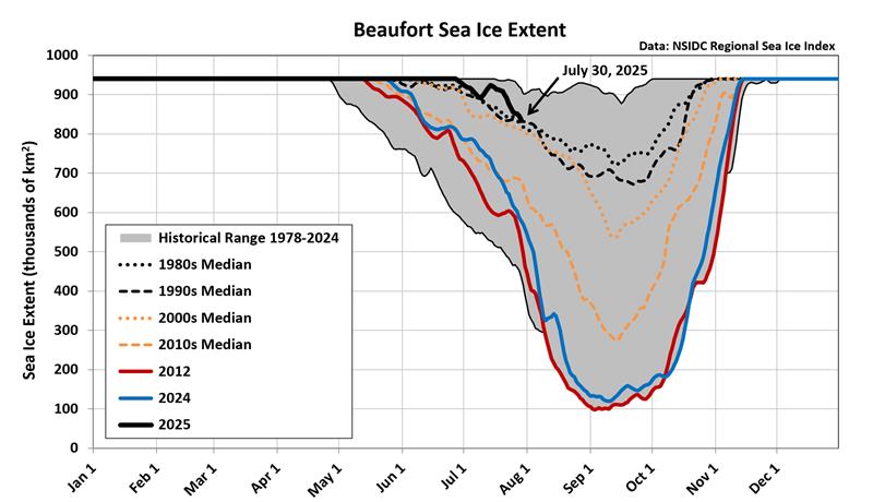
-
February 11-12; 12-13: Are they real??
Winter Wizard replied to stormtracker's topic in Mid Atlantic
Very slight tick north it seems with a tad weaker confluence over New England. No material changes, still 6"+ verbatim for most. -
February 11-12; 12-13: Are they real??
Winter Wizard replied to stormtracker's topic in Mid Atlantic
Seems more often than not when conventional wisdom and every pro forecaster leans one way, you'll want to bet on the opposite occurring. -
February 11-12; 12-13: Are they real??
Winter Wizard replied to stormtracker's topic in Mid Atlantic
This strikes me as a somewhat lite version of 1/6. I think most south of US 50 are good for 6"+ and 3-6" up to near the Mason-Dixon Line. Fairly straightforward setup here, main concern is surface temps being close to freezing. That, plus a progressive pattern will limit the upside and I would be skeptical of pushing double digits. Exercise caution on models currently depicting that. Certainly mindful of potential adjustments north, but not quite sold on that yet. Still, this should be another warning event for most of this forum, and will cement a pretty solid winter that was better than I think anyone could have hoped for. And still more chances to come down the line. -
Strongly agree with this call, Ray. Honestly seems like a very cut and dry forecast for this area.
-
Widespread 4-8" looks like a solid bet for most of SNE.
-
Tracking February 6. Light to moderate event potential
Winter Wizard replied to Typhoon Tip's topic in New England
I'm becoming increasingly convinced no one in SNE sees a changeover to rain. There has been a clear southward shift in the surface low and low-level cold looks to hold on strong. This could be a real mess on Thursday with a thump of snow ending as a mix.
-
Everything looks to be locked in for a forum wide 6-12” event. I for one am not overly concerned about N Maryland, and in fact could see that being a secondary max given better ratios, no mixing concerns, and strong lift. That often happens on the north side of a sharp gradient. The hi-res models coming in wetter and more expansive on the northern edges do not come as a surprise to me. Regardless, looks like the best storm in years for many and well deserved. Hope you reel it in!
-
Tropical Storm Debby: Mid-Atlantic Impacts
Winter Wizard replied to WxWatcher007's topic in Mid Atlantic
CSU AI models are pretty bullish for the severe weather and tornado potential on Friday. Maybe overdone, but that is always a concern whenever a tropical system passes to your west.
-
Yeah, it's very much a pick your poison situation. A near miss for Jamaica would likely translate to worse impacts for the Yucatan. And a stronger storm is more likely to skirt northward between the eastern US ridge and central US trough, increasing the odds of US impacts. The west/weak and north/strong spread is pretty evident on the 12z models.
-
Wasn't a perfect environment but it did manage to go far enough south to dodge all the traditional early season barriers, including the area of high shear. Not to mention the consequences of record warm SSTs for this time of year.
-
It cannot be emphasized enough how unbelievable this is. Not much to say except Beryl has defied pretty much all sense of climatology and conventional wisdom. It's going to be a long season.
-
Can you provide the source of this data? Image or link?
-
Pivoting to Bar Harbor and will likely move north from there on Eclipse Day. The farther east you can get, the better I think.
-
April 8th Eclipse- Last Easy One To See In My Lifetime
Winter Wizard replied to Interstate's topic in Mid Atlantic
I decided to abandon ship in Texas and opt for New England. Logistically pretty easy to pull off, and it's hard to ignore the data. I actually think DFW area northeastward to southern Illinois could also be a sweet spot since they're between the two shortwaves. Best of luck everyone. -
I was supposed to go to Texas for this but decided to pull the plug and stick to New England. Aiming for Maine since I think the eastern side of the blocking ridge has the best odds of surviving any last second trends.
-
April 8, 2024 Eclipse
Winter Wizard replied to Cat Lady's topic in Weather Forecasting and Discussion
I decided to pull the plug and go to Northern New England instead of Texas. Logistically is pretty easy to switch, and I think the omega block should hold strong, at least if you're in Vermont and Maine. I actually think Arkansas to southern Illinois may also be a sweet spot sitting in between the troughs. Best of luck everyone. -
April 8, 2024 Eclipse
Winter Wizard replied to Cat Lady's topic in Weather Forecasting and Discussion
So the plan is to fly into San Antonio on Thursday and leave Tuesday - I've had that flight and hotel booked for months. If we get rerouted, I think the most likely plan would be to spend Sunday driving toward AR. If it turns out we need to be in MO/IL, may actually end up leaving Saturday or just get up at the crack of dawn and push as far as we can. Ideally, if we have to move, it would be within reasonable distance of STL or MEM, so I'd fly from there to San Antonio Tuesday evening, then push my flight back to Wednesday evening. The absolute last resort would be to fly into New England and head north but logistically that's very difficult for our group, who's coming from all over the US. Any chance you could get in earlier? -
April 8th Eclipse- Last Easy One To See In My Lifetime
Winter Wizard replied to Interstate's topic in Mid Atlantic
I don't think the cloud cover maps are worth anything at this lead, but I'd be lying if I said I wasn't nervous for TX. Pretty overwhelming signal for at least some cloud cover if not precip at the leeside of the trough. Need that thing to hold off 24 hours or so. Odds have of sunny skies have definitely increased in New England and near the Lakes with the ridge, but I caution that mesoscale processes that can't be sniffed yet have often ruined sunny days. I would not really feel comfortable on the northern edge just knowing climo. I'm staying in San Antonio but bracing for a backup in Arkansas. Backup to the backup is in Illinois or Missouri. And final option would be Boston to northern New England. Hopefully doesn't come to that. -
April 8, 2024 Eclipse
Winter Wizard replied to Cat Lady's topic in Weather Forecasting and Discussion
Deterministic models tend to vastly overestimate cloud cover in the long range. We won't truly have an idea what the situation will be until we start to get into hi-resolution model territory. I would not be concerned on the southern edge of the path yet, nor would I be spiking the football in New England or near the Lakes. There are lots of ways that this could still go wrong on the mesoscale. I say this as someone flying to San Antonio, who is prepared to reroute if need be. -
When I first saw the headline I imagined it was like the Philly bridge collapse last year and that it was only a small segment of a bridge that would be repaired in a few weeks. Seeing the entire thing collapsed made my jaw drop. I've taken that bridge a few times to go home when I lived in Maryland, and whenever I drove on that or the Bay Bridge at night, I always felt a little uneasy for that reason. I've felt that way ever since the Minneapolis bridge collapse a while back. Just a terrible tragedy and there are going to be significant supply chain and economic ramifications around here. Not to mention traffic through the tunnels, which are a major artery for East Coast travel, will be even more of a nightmare.
-
April 8th Eclipse- Last Easy One To See In My Lifetime
Winter Wizard replied to Interstate's topic in Mid Atlantic
Nice. I'll be flying in Thursday and staying until Tuesday. Sunday and Monday will depend on weather conditions, but probably going to be somewhere within a few hours of downtown. Very excited, never been to that area before.


