

Typhoon Tip
-
Posts
44,568 -
Joined
-
Last visited
Content Type
Profiles
Blogs
Forums
American Weather
Media Demo
Store
Gallery
Everything posted by Typhoon Tip
-
Euro tried to do that earlier this last June with Claudet...also traversing some 800 mi of land post a landfall while selling it as a strong TC almost upon emerging on the Del Marv and keeping it that way over the cold side of any warm water astride NJ... nope. It did deepen some when it came off the VA Capes but it's trajectory was flatter and attained better proximity to the Gulf Stream then that thing there. That's over 59 F water off the Cape and is strengthening in the intervals lead that depiction - nah...
-
Just based purely on 30 years of this pointless distraction ... that experience for some reason doesn't like the look of hashes that squeeze the N edge from slgt to nothing over a bike ride's distance along a straight west to east axis -
-
Dog day pattern if you remove the GFS speed bias ... basically slow moving low amplitude waves that have weak CAA and modest WAA defining their transport media - should be modestly above normal after the Tue/Wed 'faux' heat wave. although i suspect this will be like the 19th thru 23rd of June, where it's 88.9 at all ASOS but 91.2 over everyone's driveway, parking lots and thoroughfares them two days .. 'maybe' Thur makes the cut. These huge ridge heat dome phenomenon have not had that much longevity.. It is interesting that they are not defining in the seasonal scope - more like the oscillatory nature between those and offsetting cooler periods is the distinction. Not sure what that means, other than weird - California's interior Central Valley looks doomed again D5-8 ...then the flow out there and here looks flat under hemispheric +decimals SD canvased positive geopotential medium. like this oscillatory behavior wants to diminish toward more typical summer entropy
-
18z NAM puts up a 95 supporting atmosphere at 18z Tuesday for interior/metrowest
-
I know I never seen nothin like that with no outs
-
Epic play at the plate to maybe save this game wow - Onto the 11th ... Oakland leaves ‘em loaded too.
-
Historic Pacific Northwest Heatwave of 2021
Typhoon Tip replied to donsutherland1's topic in Climate Change
They were both an example of synergistic feedbacks. -
Heh Watching the Red Sox with that glowing yellow brilliant sun blasting sideways across the field it just seems like it’s got to be on another planet in a galaxy far far away
-
agreed - been trying to advertise tomorrow as 'not as bad as the grouse tempo' This morning there was a lot of hand waving/86ing of the whole weekend - ha. Today is unredeemable sure ... It's almost a split in Boston, if this 18z NAM has any say. It's continued the trend to edge/inch the lower 700mb RH E, and now has ALB-LGA pretty much partly to mostly sunny by late afternoon. I think the present hi res vis loop shows how this is going to go. You can see it's breaking down out there in PA/NY where's we will be in relation to the filling vortex come sun up... I suspect that partly cloudy is at least in the ORH Hills, and where I think it 76 F at 4:30 pm or thereabouts and probably above MOS... This is only going to continue improving east through the evening. But the bigger aspect is no rain and dry roads and drying fields. Should be okay I think. 'Sides, full disclosure ..I don't want it to be 88/72 on 4th of July. That's not fun standing around with paper plates in that heat with deer flies doing mobius loops around your head in backyard cook-outs.
-
No ...I don't think so anyway ...oh wait maybe Boston. I thought they were 60 ... Most likely if there were, it's not pervasive enough to give this scenario it's shit eating grin - it's zero redemption rectal plaque
-
This happened BECAUSE of the heat - namely and more precisely, the exotic SD ridge anomaly in lower BC and Manitoba caused the heights to unusually plumb S through the eastern Lakes - that out there drove this... ? that out there was a 1:200 year deal ( supposedly ..) so it's almost quasi logical to say ... this was also that rare. Probably not in the absolute sense, but geesh - what the atmosphere has to pull off to do once, and get everyone to grouse like it's all the time. lol That said, the poster's post isn't without merit, entirely... I just as well leave on April 3 and not return until May 20 ( end time negotiable too ) every year if I had my druthers. This is April today
-
If you look closely at the rad loop you get an impression of OE slipping underneath the advance of that plume, too - like my god.
-
His point is valid though - the models do tend toward pessimism in the summer ... I think in this case, however, that may be more demonstrative tomorrow. We'll see - don't shoot me Even today ( in a way..) ..we've had a couple of periods of day-glo-lamp brightening despite the cloudy skies with occasional drab rains. Which btw, can't prove this but it may have been what prevented ORH the record - just that amount of very modest almost imperceptible heating. Whatever it takes to make it less interesting huh - jeez I mean this is only like this because of excessive moisture loading - really. I mean, it's not a 55 F air mass, not by tropospheric thickness? It's just preventative - I'm digressing into another aspect I know, but this is really kind of like bootlegging a near historic cold high. See, typical rainy cool profiled days in July should 65 ... so in that sense, it is an impressive cool anomaly, but really only by 10 degrees relative to butt-bang weather. ha -... but you get my meanin'. If it were partly sunny with a NW wind and it was 55 up on the hill, that would be more impressive - but that is probably something that can't happen. Maybe in order to get any kind of < 55 day requires a butt load of NE flow and driving sheety mist under a 10K foot deep ceiling
-
Patients is a commodity around here... particularly for a nerved vitriolic corral of Holiday-weather abused, but it seems tomorrow might be better than these guidance, similar to what is going on out just W of the Cap District of eastern NY We'll see.. not sure of this, but I don't see this whole thing as deepening - in fact, after this last gasping slug of death rain it throws at eastern CT now... this region may begin to translate in for tomorrow.
-
wow... Red Sox with 8-G win streak on-going .. I knew they won lately but I didn't realize it was that deep. (Law of averages + west coast road trip) /2 = ...proobably a trip back to Earth here sooner rather than later but we'll see.
-
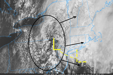
How dare one mentions weather concepts in a banter thread but ... I can see this whole thing starting to break down actually - The closed gyre is filling and this can be seen by observing the various attributes of the sat loop. The higher air motion is peeling off/tending to more E and taking the higher cloud RH with it. There is a slant-wise incursion of air flow now punching into the NW sectors of the total trough space, from western Ontario, and western NY and N NY are improving rather abruptly - I don't even know if that was modeled well? but those regions probably desolve out to partly cloud with plenty of sun splashing before mid afternoon ..probably as far E as the outer western region of the Capital District of eastern NY/Mohawk Trail. Today's shot. But I suspect that tomorrow may have been overly pessimistic in the guidance. Typically, with backside troughs, exiting GOM, we end up with enough NW drift to d-slope and models notoriously keep drizzle and murk ( snow showers in the winter version heh ) going too long when regions verify partly sunny. Granted the wind is light in this case - kind of sucks ...you want more defined d-slow motion, but there is enough there. We'll see if the erosion from the NW mentioned above continues to en road in, and looking up stream that appears to be a bigger synoptic push ...so this thing may actually in total be too conserved in guidance by 6 or so hours...something just enough to save tomorrow afternoon ... Who's with me!! lol... no seriously I think tomorrow improves. Not sure about others but we have Monday off in observance and ...hey. Day off + 80 + less clouds and tepid dps ? I'll take that.
-
Yeah, even the MEX has FIT/ASH/BED all 77/91/88 for those three days. The Euro has the warmer synoptic appeal. Typical for the GFS ..particularly beyond D3 ..where/whence it has sufficiently accumulated enough cooler heights on the polar side of the mean jet as a dependable, mid range crushing performance piece of dogshit - I predicted this last winter ..heh, "predicting model bias" as it were. The GFS would not be a very good tool for early heat detection out in time, because of it's hemispheric rasping. Anyway, point of this is that it overcomes that native bias and at least gets Wed/Thu more +6 in the high on climo numbers - so that could be a tick or two soft due to climate weighting, too. My bet is that the Euro 'mos' would be warmer on Tuesday given to +18.5 C over the region, lowish ceiling RH and offshore general flow.
-
-
Predicated on the assumption there is anything there lol - I see a low level core occasionally decoupled from the convection. I don't even see much evidence of westerly shear - this seems to be just storm-relative induced for having the low level flow screaming along at ludicrous speed, anything caught up in it, including this coughing Elsa is moving redic fast relative to the mid level troposphere down there. In other words, it's sort of producing a shear from that anomaly - You can thank excessive subtropical ridge strength for that - and don't get me started on what/where/why that is the case. Anyway, if this thing continues to dislocate from its stack and then goes across Cuba, it won't likely emerge enough intact then survive Florida, and those track coordinates out here in time will be tracking a theta-e plume and not much more.. becoming phantom
-
This seems(ed) predictable to me. I've said this before. Anomalies are more often than not corrected within temporal sites ... either with ~ mirror magnitude, or doing so in the aggregate ... to keep seasons and years from getting out of hand. Whether we got today and tomorrow or a week in the 70s ... it was almost a foregone conclusion. At the end of the year climate change is defined by the arithmetic remainder
-
California may be in line for another historic heat run
-
It was always espoused by climate modelers that the change, despite the ‘warming’ adverb, is more oft expressed by volatility/ increasing occurrences of relative short duration extremes. Now I’m just a caveman but this week seems to suddenly qualify
-
Historic Pacific Northwest Heatwave of 2021
Typhoon Tip replied to donsutherland1's topic in Climate Change
This won't sound altogether cogently scientific, admittedly .. but, I get the weird 'feeling' this is ...sort of an introduction ceremony into a new climate realm where this occurrence takes place in certain regions with more ease than those staggering odds implicate in rareness. I have some analytic reasons for that, but I am trying to limit my verbosity in social media; in an increasingly patience reducing/aversion to spending that much time with it, it's wasting time. In short, there are regions of the planet that favor "synergistic" results. Those by convention ( being more than the sum of the contributing forces ...) will exceed the mean standard deviation models - by these exotic ranges, more readily so than regions that do not have feed-backs. Those location will be able to get those +8 and +10 oddities over that base-line numerical/statistical layout. The Pac NW is one of those regions. I think the Pac NW and also San Francisco and L.A. can do this again sooner than we think. The shit with fires and heat last summer ? that was no fluke and is related - whether the scalar values of the extremes match or not. And I would tend to assert that the aggregate speaks to the real state of the 'rareness' - I.e. not as much so as we may think. -
lends credence to my PR hypothesis in NHC - I don't like it either. I realize their charge is to inform officials/ media, but it shouldn't be their charge to protect people by goosing attention awareness. That's on the officials and media - I dunno - don't wanna be in the habit of impugning them, but this thing is dubious like so many other cyclones that near population and suddenly get a kick up in category - it's enough of a coherent pattern. Just sayn'
-
You can see on satellite ...we actually had a shot at improving sky conditions here but that training rain bomb shit in the HFD CT corridor is dumping debris clouds up here, capping the murk and keeping our heads jammed in butthole weather


