

Typhoon Tip
-
Posts
44,568 -
Joined
-
Last visited
Content Type
Profiles
Blogs
Forums
American Weather
Media Demo
Store
Gallery
Everything posted by Typhoon Tip
-
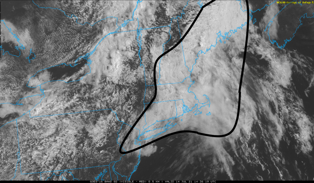
This clearing line edging east through eastern Mass is legit. Explosion of open sky sun happens at the scale of street width when that goes by Now, regular diurnal CU fills partially in. Also, area home stations bolted from 74 to about 82 so far. Average DP is 74
-
actually the sun is cleaving through here.. the mid and high gunk was not well modeled by the NAM and other short range guidance ...It capped the low levels from morning insolation so... that's why the morning busted a bit cooler than guidance. It may late recover - not sure what the bounce ability of this air mass is. My guess is not huge - considering it's a mixture of toxic Labrador sludge and high DP rot from the M/A.
-
WPC just updated their surface map ...seems far more instructive on this interval -
-
wait ..are you female? Not being a jerk - I don't know you. Heh. let's face it, female physiology is a bit more ... "responsive" shall we say to cool settings. Something I have noticed in the past - ahahahaha. No but its true
-
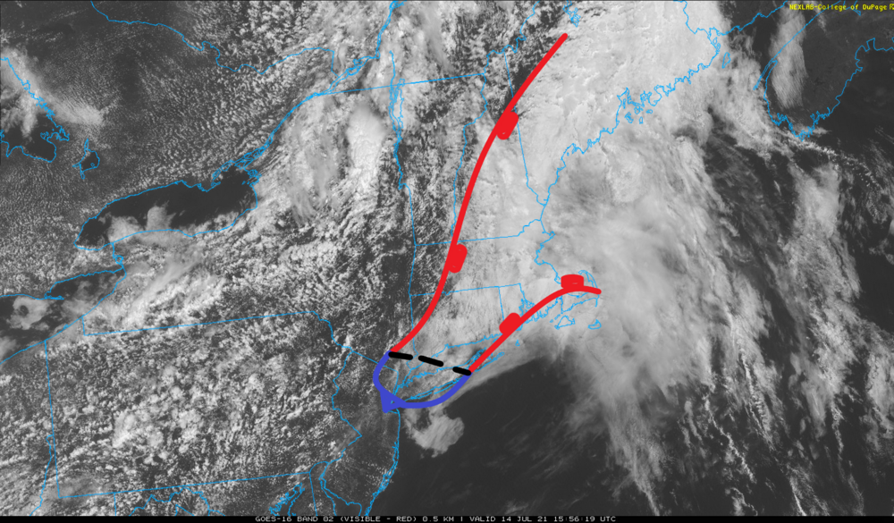
This is secluded at this point... That region E, over the ocean, is more open sky than not and moving N with cloud tags. Meanwhile, the region enclosed above is demonstrating on-going resistance, and cloud parcels ( looping this image ..) are moving over top. I've likened it to white paint spilled on a freeway surface, with the cars ( cloud parcels ) and other traffic passing over it. It's like that. When looping, it's almost as though it has a resistant polarity to free air, or an "electro static" kind of force holding it in place. it's really like 75 mb of calm air inversion at the bottom. In any case, the edges of this region have been eroding inwards at the blazing speed of about 5 mph
-
What the hell are y'all running in... chafed nipples? I've been running 30 K/ week for years, ...three 10 K runs, ... It's 6.2 miles, so 18.6 is a typical week. I get black toe here and there - mainly because I forget to check my toe-nail length and that starts that. Sometimes an edge of a toe-nail may at first, too gently poke an adjacent toe to notice, but over the course of many thousand foot falls... sometimes I don't feel that until I'm back and there's blood in my sock - not a lot, but oops. So, yeah, shit happens to runners. But chafed nipples - how do you do that?
-
Heh...looking at hi res vis loop, almost looks like this BD air mass has secluded itself. S flow over the ocean and now cuts it off over top in NNE, leaves this latext paint spill clinging to the land from NYC to BOS ... Can you imagine if just stayed that way until next June. Whole year of that -
-
Step lightly the rest of the day my friend. Don't take any chances. Don't make any sudden movements. That's a shot across the bow - " its " giving you warning ... don't mess with it. LOL You know, you hear about these fluke accidents that defy absurdity - go beyond description. On 495 like ...10 or 15 years ago, there was this freak thing. Some construction vehicle with a high-tension industrial spring-loaded boom was toolin' down the highway, said boom was negligently/insufficiently clamped. Now, that tech is mechanized/designed so that the spring-tension doesn't actually release it's stored energy ( aiding the extension of the gantry ), until the arm exceeds a certain extension. So there it was, unclamped, fully spring loaded, bobbing gently up and down as it went over the highways surface "rosby waves", precariously ... just below said threshold. Anyone else's luck would have prevented what happened next. Some women was passing on the right as the truck went over some slightly more elevated rise in the road and that arm bobbed up, over the threshold, the spring releases ...and because it was not released in concert with the hydraulics ...it explosively released all at once and came down like a cosmic hammer on the woman's vehicle as she was passing... Flipped the truck, too - it was like so much rage targeting that hapless passing small vehicle it had to flip the whole truck like an angry pro-wrestler's move. Can you imagine going 74 mph and the equivalent of 10 ton out of no where, in a flash, instantly grinding your vehicle into a FUBAR smear down a quarter mile of sparks and smoke and twisted industry? That's just beyond freak probability. That shit's something else. heh. You almost wonder if she was on a bike ride or a run that morning and nary missed -
-
Meanwhile... SPC places a region of NE inside a SLGT hashing that is precisely where it always fails
-
We'll see if it holds. I have a suspicion we finish +1 anyway ...which is a relative win for those that don't prefer summer, for a lot of reason. ha! It's the way in which these/those neg values got aggregated - it took a bizarre pattern anomaly to do it, with 594 dm ridge anomaly actually CAUSING a cold surface - using observed means that were probably pretty rarefied frankly. It's almost (symbolic) as though it got so hot in the mid and upper troposphere that it caused things to flip by way of inverting the sounding too much. But ... that odd timing of that surface high genesis and movement over the last 3 to ...jesus 4 days now, has really happened in a range depth of Rosby heights, both hydro and non hydro static, very seldom seen, and as a consequent, we sustained a cold low level jet right under some otherwise extraordinary warmth aloft. Very strange - Talks about faking cold. Whatever it takes to keep balance the climate loading. I have mused this in the past... Usually when you have a striking climate departure, usually start seeing a counter/mirror or diametric balance emerge, whether in short extremeness, or in aggregate...usually not too far away. Sometimes that does take awhile when it is the aggregate form. Put it this way...if we were -2 for July ( also very plausible...), and -3 for august, we were average for summer. But the sensible impact for summer enthusiasts was a gip-job shirked piece of shit stolen season. Same bullshit happens in winter. All a season's worth of snow eggs laid down in two storms in CC PWAT mass, then it never snows again. Average year? Just making zamples... But, June was staggeringly warm here. I don't know if that is sustainable for a summer- intuition tells us no anyway. I don't know if July can manage to sustain -4 when it took the above rareness to get it that cold, and there is still two weeks remaining... and that base-line heights are positive through the end of the month in the ens means of all. It'll be interesting.
-
What's interesting about that thunderstorm is how rogue it was ( seemingly targeted and intended may be a better description lol) ... There is/was nothing else, anywhere else at the time. That thing developed just west of HFD and moved precisely tracked to clip your location and run-rought ( here'e comes - get 'im). Within 5 minutes of your return from that run, it was entirely vanished from the radar scope. Nada. No sign there was ever anything there in so much as a level 1 green clump down stream. https://weather.rap.ucar.edu/radar/displayRad.php?icao=KBOX&prod=BREF&bkgr=gray&endDate=20210714&endTime=-1&duration=4 I've had that happen though. Cycling is a bitch. Mile 16 and 8 to go ... blinding rain and flashes and hold-up under a bridge. Get home and find that it was a three pixel 50 dbz micro-core that lasted precisely as long as I was going to be passing through that neighborhood. I usually lay low the rest of that day knowing that God is throwing bolts at me. Some people ignore the signs HAHA
-
I’m not sure folks are actually believing their hyperbole about how bad things are right now… But if they are, tomorrow’s going to be a complete shocker - predicated on the assumption that the last three or so cycles of the Nam run or actually correct…LOL This FOUS T1 run supports a 2 m temperature of about 29°C with the dewpoint around 22 or 23°C probably 5 to 6 PM tomorrow late afternoon over all of metro west of eastern Massachusetts to Hartford to New York City. Anyway 85/73 … then 90/73 Thurs
-
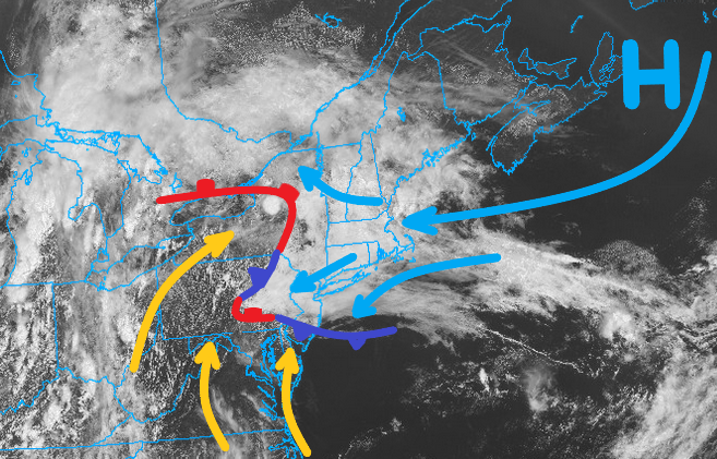
As the annotation earlier suggests and this, until this higher sfc pressure gets the hell outta those regions of E and N of Maine... we be f-ed
-
Yeah, okay - but I suspect they are low-balling the DPs in this discussion. Hell, even the NAM has 71 DP in the machine numbers, which from my own experience is a hard thing to do for that particular guidance engine. " ...Northeast... A shortwave trough will move northeastward across the Northeast on Wednesday. A moist airmass will be in place from the Mid-Atlantic into western New England where surface dewpoints should reach the mid to upper 60s F. As surface temperatures warm during the day, the airmass will become moderately unstable. Thunderstorms will develop in the higher terrain of the central and northern Appalachians, with this activity spreading eastward into the lower elevations during the afternoon. The moderate instability combined with steep low-level lapse rates will make strong wind gusts possible with the better organized multicell line segments. The threat should be concentrated during the mid to late afternoon when instability will be maximized." We'll see... but, considering DPs in that warm sector about to spill into the area tomorrow are 70 to 74F already, and it will be wafting in over tropical soils baked in solar max sauna... I'm -a gonna go ahead and assume our DPs will be at least that high. Which makes me wonder what they think the CAPE values ... SB and MU, will really be if they use words that "sound" like through trials and tribulations the air mass endures and triumphs to make 68 ...LOL
-
So now there is this counter--push to disavow the Wuhan Lab/ ... covert bio-toxic weapons program leading to an industrial accidental release scenario - Okay. And round and around we go.
-
yo Wiz ...I think with the recent guidance attempting to spill the theta-e surplussed ... global warming ( ) sector over the western elevations tomorrow, that may help some convective numbers. Anyone caught in negative CAPE production probably gets water boarded in blue-green marine rain cores for starters. Probably wet outflow winds
-
For quick and dirty map annotates it's actually pretty convenient - I'm at work now so on a laptop and it's not a big thing. Also, fixed the frontal pip because of ocd
-
uh huh, and maybe I did that on purpose cuz the whole situation is whack and it's a metaphor for bass ackwards - huh. Yeah. who's with me
-
The root of Scott's demon: It's gotten a little brighter in the ceilings over the last hour up here in the N-central interior. After some bullet showers, hanging over the top of this Atlantic rhea moved off and took their anvil umbrellas with them, it's opened the sky (pretty much about/above 2,000 feet) to solar max whalin' away at this shit. Probably, we thin all at once at 6:34 pm - seen this over and over again. Smacks your ballz with "edging" sun late. One of Globe's sports writers once coined the expression, 'winning is the best deodorant' ? I think that can metaphorically work in this situation. We string 3 or so days of 88 to 91 over DPs in the mid 70s together, back to back, this will all be a distancing memory. I still think that it is interesting ( extraordinary really...) that we did this pattern annotated above, at the very top of the geophysical envelope of heights in the total tropospheric integral. Baffles where it came up with the mechanics against the ceiling like that. I think I know why ..as I labored earlier, having to do with HC and shit.. either way, here we are. There have been now 4 of these 594 historic ridge events, this one presently/fascinatingly results in negative temperature anomalies. It's really quite a bit of a teach-able synoptic moment.
-
NAM has that, yeah - in fact, goes from this tepid humid rainy murk to a sultry bathe house tomorrow... Not so much at sun up as amorphous warm frontal smear road-kills through but the 18z T1 pops all the way from 17C at dawn to 24 C ..which is usually a 2-meter T of 28 or 29C when the wind is off-shore and the sky is losing cloud burden. Then at 18z Thur that temp is 26C ! That's like 88 to 90, and situational awareness ... DPs will be probably the highest they have yet to be during this summer thus far at that time. - watch Whole different world
-
I think this is another innocuous example of how the HC expansion shit is f'ing with 'normal' circulation modes. The correlations that normally realize/situate are getting skewed. It's not just screwing up winter by speeding the flow so vastly, that the R-wave distributions are unstable.. This is a sub -Rosby scale example. I'm certain of it, but cannot prove it without an army of grad-students to do all the work while I publish the paper and bathe in narcissistic glory ... LOL. kidding. Longer version: one does not typically observe cold air loading into the lower levels choking the entire synoptic-scaled region, while a west/near coastal ridge node balloons to ( yet for the 4th time this late spring into summer, too) near historic proportions. In fact, in my 35 years of being privy to this field of science and theory? I have never seen surface temperature struggling to rise, coincident while non-hydrostatic heights soaring to the mid 590s, not while hydrostatic thickness' are also well over 570. I have seen thickness' be disproportionately lower during higher heights in spring - but that's related to low DP thermodynamic integration in the column. This is not that - We should be 100... 64 That's got to be the most extreme disconnect ever. We're talking about shedding nearly 40 F of potential. So direct reason for that oddity: The cold loading is coming from an E trajectory off the north Atlantic... a flow that originates from high pressure that refuses to settle S of the 40th latitude line. I mean from the look of it at these standard product intervals,, it seems to hang in free space defying. The high pressure, itself, is typically not manufactured at height intervals this upward extreme/or at the upper bounds. But this is where the HC idea comes into play. It's enhancing the summer polar jet, by virtue of increasing the gradient along the 55th parallel - in the means. That sends unusually strong confluence potential through that band, as well as just organizing more wave structures that are going against the more typical summer nebular entropy quotient. ugh. I know. Anyway, that organized wave spacing and enhanced confluence saw an explosive rise in heights ABOVE the 576 dm over western Ontario over the last couple of days, and now that has propagated E ..but the surface high is still be generated along that total transit of mechanics. Now centered S of NS, it is drilling mass west under heights that we dont' typically see that happening. Whether it is HC expansion of not... that was an unsuaully strong rising height event over Ontario, taking place at/within a range of geopoential heights ( non-hydrostatic) that typically does not do that. 564 to 582 is more typical.. Heights rise through that range, that means there is confluence and surface high pressure forms and send BDs and N-arriving boundaries down the M/A...etc. This is doing that whole ball of wax above 582, which is unusual. Another casualty of all this? convection. Naturally, if you pin surface reading to just 70 under heights and thickness that high, there is zero omega and zero instability. May as well completely consider the lower atmosphere decoupled entirely from any aspect above the 700 mb level - in fact, the standard chart intervals are really more miss-leading as to what the "surface" synopsis is being forced from.
-
They engineer all these geomorphologies to conserve hydro and they work reasonably well in ranges from low, to on point climate … but unfortunately, that doesn’t stop being proficient when in surplus.
-
NOOooooo sun for you - ONE YEAR!
-
incredible moosh job going on. clearing and NE push behind BD is entering NE zones as we type, but that boundary is not moving SW of current location over NYC... Something's gotta give
-
Ironic perhaps ... "activist" by definition and expected nature is supposed to be consistent with "social awareness," which if so .. is in an inherent conflict of interesting. It's why ( logic ) argues they are glib, pumped up and pimped fakery that is targeting to sell to those groups. It's kind of both in that sense? They may have the interests of the targeted group in heart. They may not. But the "partisan" part - yeah... Targeting means excoriation of the other side by default of message.


