

Typhoon Tip
-
Posts
44,568 -
Joined
-
Last visited
Content Type
Profiles
Blogs
Forums
American Weather
Media Demo
Store
Gallery
Everything posted by Typhoon Tip
-
This is over in an hour even NE Mass...
-
..its called a coffee can and a ruler ha
-
It's like when looking at obs ... this thing just detached its self from the tropical bundle of air it was transporting up and has left it behind. So now going forward it trundles away as a mid level residual gyre, raining it's self out over the next 3 hours over SE NH and lower Maine.... meanwhile, suns out in CT ...about the terminus of where the tropical like air was left behind. Really more like NYC. Yup, one way or the other, true tropics don't come N of LI. ahaha... in general. kidding but yeah. It's why what you have to have is a full bird beast rounding the outer Bahamas with the western limb -NAO block guiding it's latitude ascent at Sutton Massachusetts at 55 mph or forget it. It's some kind of mangled variant otherwise.
-
it's an apt description for here as well, just N of rt 2 in Mass yeah This things structure seems to be breaking down/weakening overall sat presentation, and rad, too. Not sure how that holds up to the model's profile of this things evolution, but that's what I'm seeing
-
Last few frames on rad show it weakening before the back edge now. Seems this thing's attenuating - my rain intensity is back down to light, so getting shirked/low-balled a little.
-
Hard stop back edge/arc now over HFD... Sun breaking out ~ Danbury ...
-
Back edge/arc is sweeping through western CT. Kevin you got about an hr and this shuts off like across a 2 minute span... hour later, you see the sun perhaps - fuzzy but has that appeal -
-
Yeah rad suggests you are collocated right under a band -
-
still waiting for that signature roaring rain din ... It's only been thus far light to moderate here in Ayer. It's cool feeling - rather refreshing. Like a cool drink of water. Feels autumnal. This lead air mass will fight to the bitter end - and win under the sounding probably. Just guessin' will see if we disk this thing over top tho - I wonder if this keeps doing this tho. Where ground truth keeps dematerializing to lighter posh as it sweeps NW in these arcs, and every time we look at the radar, it's just about to really set in... Heh. I could see that. 495 hard as a pedestrian cut-off. Mind you half kidding - not a forecast or nuttin'
-
This is a geek's paradise for that sort of nuanced observation - yeah. Arc has finished in NYC and even the western 1/3 of LI is in the clear. High res vis loop suggests one last arcing high level band SW of the city down there in NE Jersey then it's open sky in in a 576 dm thcikness bath? Yeah, the NAM has 28 C at T1 at Logan nearing 00z so... that would support a Midtown temp of 90 F... I suggest that gradates to 74 up here where I am, but even I may get a burst of slant sun between 5 and sunset here. Anyway, it's interesting that a backside cyclone is warmer - we see that sometimes anyway... when there is colder air in the front sector of cyclones, but ...this isn't that type of cyclone, and the air mass thermally is mirrored
-
I wanted to catch back up with this aspect sooner but ... heh, admit to caving - with reluctance - into this Elsa shit as actually being interesting. LOL Just kidding. It is.. a little -
-
This post of yours is dated to yesterday ..granted, but just in case, pump the breaks. Highly unusual, but despite those extraordinarily tall non-hydrostatic heights, idiosyncratic flow structures at mid and upper levels across SE Canada, transiting toward the lower Maritime, have materialized in all guidance across the last 24 to 30 hour's worth of cycles. It's getting consistent and hard to ignore. As a result, they necessarily have to bank an unusually cool air mass into Maine/eastern NE, while 1025 to 1032 mb high slowly passes, blocking/pinning defined front from roughly W NY to S NJ. It is unsual to see that happen right at the very top ceiling of 500 mb atmospheric height mechanics. It' not like this is spring, where it's happing between 565 ad 580... there are no height higher than that ridge dome, yet the models still want to jam 62 F at Logan under 594 dm heights from Monday to Wednesday. It's just perfectly wrong timing emerging out of now where, wrt to confluence and an over-active mid latitude Canadian westerlies band. It could result in the most dramatic surface unbalanced return for heights so high that is even possible - I mean, top of the chart heights, bottom dweller summer air at the surface. I recently opined to Pope about a similar phenomenon that's been increasingly observable over the last 10 years, and then this materializes in the guidance - seem apropos in timing. But this is a recurring thing where the models manufacture low level nuances and aggregate their ability to offset the higher heights/thickness. Boston could very well be, 594 dm heights over 574 dm thickness, with a 62 F chill in easterly drive train drilling salty oceanic air smell-able half way to Albany in that look. Not saying it will ... just that the 00z runs are no where near even warm N of mid Jersey in that layout. All happening in climate edge ridge depths. It's hard to ignore this... It seems the further the world ventures into this CC stuff, the more the model physics seem to fight it? It really casts that allusion of sorts. We keep seeing these mid/extended range modeling obsurdities - and face it, sometimes they happen. You just are not going to see that kind of curved mid and upper ridge signature with that going on below 700 mb - it's like the models are trying to hold the surface in 1955 while the middle troposphere is Venus.
-
Yeah...that's a good point about backside breeze... I don't know if an actual sting jet really materializes, though. Sure, it certainly parrots one in that look. - the thing is .. in the stricter sense the stinger is an upper level entrained jet and I'm not sure this one has that structural component - but other physical processes support the presence of one, despite not being there - sort of 'mimics' one doing so? Bottom line, not sure where the sting's momentum comes from. What it does have - I'm thinking - is a bit of an isallobaric wind acceleration potential - how much... how little so. The compact structure of the lower pressure layout it, ..well, firstly it is not over-impressively deep. But still, it doesn't have to be very deep if the actual gradient is steep by virtue of being very curved, which is this clearly is. SO, 1001 mb back to standard sea level or more can do some interesting gusts perhaps.
-
Those side lit crispies in the lingering Bahamian type air would be pretty illuminated while looming over their blue-gray bellies and charcoal dense rain curtains.
-
Sun's out .... .... in Hartford CT by 4pm maybe? Looking at everything there's a back/underside subsidence ring and at least partly sunny over eastern PA/N NJ with a back edge rollin' right up with this thing's motion suggestive by looping. I'm also hoping that the center passes over Logan so we can watch the BD air mass die by slip knotted wind - alas it prolly passes SE of there. just sayn'
-
Scott's getting figuratively water-boarded like a revenge party at Guantanamo Bay Cuba, circa 2002 and finally he admits to " ..a bit of Stein break" LOL That's fantastic -
-
Dude ..I'm tellin' ya, that Dec 2005 right there
-
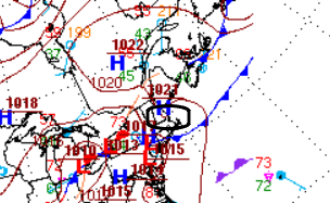
This whole ordeal/cyclonic passage is meteorology nerds paradise. It's an ambrosia of interesting stuff to pick through - One ...the whole package defaults the region into a backside warm sector - even though technically ( ..or supposedly...) it is cool-core transitioning, and should have modest CAA -it does, but it can't sensibily appeal that way. For ORH-ASH ( my line ), we'll have 69 DPs at closest pass, but the temp may only be 70... Tomorrows it'll be 84/64 so it's just interesting how its both - all it's really doing is forcibly winning against a lodged in BD airmass. Two .. at a glance this thing right now on radar reminds me of the 2005 Dec thing. It's really tight. It occurs to me, I never did actually check the storm phase diagrams for the Euro inputs - is that even possible ?? I wonder if I was too quick to judge this as a TC entity nearing our latitude, as the surface evolution of that models "looked" TC-like because it was compact. But at present sat/rad, it looks like the Euro's pressure pattern layout, regardless of the phase. I gotta figure though it still has tropical characteristics with DPs over eastern LI, SE zone in the mid 70s. Plus the rain wall/arc on the N side is unusually thick and dense and proficient, above any kind of standard ex-trop cyclonic output. The loop show some impressively cold tops and domes lurching over the surrounding canopy. Three ...Even if we don't observed 40 kt winds at the surface... these other attributes are impressive. Particularly considering this thing's track history. Bordering on a wtf storm. I guess though the idea here is that it timed just exquisitely well to conserve kinematics when it hooked up with the weak trough - getting a mechanical exit jet structural advantage. Looking at the 300mb on the guidance they have a nice exit fan up there over Maine ... albeit somewhat stretched. interesting. I'm sure I'm leaving stuff out.
-
It’s already busting in wester zones this action .. I don’t know if this meets the qualification but looks a bit PRE like
-
Just looking at the satellite loop and knowing about the quasi BD front down in CT/RI ... I think the larger environmental flow is still is peeling over the top of the low level wedge, and that's what we are seeing that tendency for back building out there SE NY to western CT/Mass. This air mass also appears to have moved farther S than the support. There is a gap in the pressure pattern N of the low level front - The front seems to have outpaced the momentum that put it south, I think owing to our suck-geography that loves to give cold air masses a bj ...
-
Prolly not? My thinking on that is that if I can get .74" in 23 minutes from a thunderstorm, I can get 3+" in a 4 hour passage by system toting along a PWAT density of 2.5" - i.e., right at the top of the climate and possible a SD beyond. But it probably wouldn't be 3" like latex paint .. it'd be 1.75 with streaks of FFwarnings
-
Indeed .. An aspect that I have found interesting is that the hydrostatic and non-hydrostatic heights have been unusually gapped, adding another oddity ( call it 'strangeness' ) about the hemisphere. Longer general musing: Typically, when we get 588 dm height layout, we're running 574 dm thickness contouring within a couple latitude-clicks on the equatorial side. But what I am observing are lot of 574-type depths swallowed up under 590+ to 600 dm non- hyrdo heights. Not so much out west... but E of ~ 110 or so across the vastness of the Plains, S Canada, Lakes ...MV/MA... NE so forth. I've even seen 590/566 .. Building frames for towering sky scraper heat, but only outfitting the building to the 10th floor. Simplest words, unfulfilled heat potential. It's like "playing with fire", too ( pun hopefully irritating of course). I'm not sure what is causing this, but it's no fluke. It's been happening in recent years too - just noticing it more so this year. Thing is, it's also sort of insidious because to the lay-person, we were 97/72 during the last week of June. Heights nearing 600 dm or not, who the f* cares, right? But that's an example where the hydrostratic heights were only (only, ha) 575 or so when that happened. We could have been 585. That's when the low stops at 84 at LGA/Logan in a 'refreshing' pilot light zephyr right out of their attendant urban heat islands. In today's post modernism reluctance to except CC ( in whatever fervor that still abounds...), that would set the stage for 95+ by 9. Outre donkey ballz SD stuff. I mean, there may be a limit to the amount of energy we can pack into the column at this latitude per solar insolation budget. Not sure on that. But, we do have a mechanism to potentially maximize beyond, and set those sort of tables. We need the synoptic-Pacific to send height surge between Hawaii and Frisco ... That would lower heights down the west coast. The total "Sonoran Heat Release" model starts with a +PNAP capping out west under solar max broiler, then that larger disruption arrives and ejects that thermal layer ( usually with an EML, but more specifically the 850 mb kinetic bomb is the impetus here) ... I think it is a matter of time that we send a +22.5C 850 mb lava lake toward Chi Town with zero synoptic inhibition to divert it. We see relative magnitude ejection scenarios, they don't all have the eastern isohypses layout ridge dome/scaffolding..not the favorable lower Maritime of Canada... i.e., a positive NAO orientation over the western limb of that index domain space. If that lifts the continental escape latitudes of the westerlies... you will draw that Sonoran air layer up here and that would complete the Bunsen burner. July 1911 104 F in Albany back when 594 dm was not the new 588 ? think about that - and guess what for Logan and LGA, when that happens and wind is WNW under 600 dm heights. "Hey, let me show you my dads gun"
-
Ventilation has swept through down here. The early morning higher resolution visible satellite loops really makes evidence how that overnight MCS that swept through laid down a pretty cool air mass and also pooled/assisted in dragging ( finally ..) that west -east lingering boundary that was southern VT/NH yesterday afternoon, S .. In fact, E and ENE trajectories, albeit light and a shallow air mass, have penetrated to N CT / N RI. And it is shallow ..I can see elevate turrets leaning and stripping off toward the NE over top, whilst these scuds and strata fragments are moving WSW underneath and lower levels. I'm guessing 3500' deep in the sounding just by eye-ballin'. Kind of interesting... albeit very want diversion. Yesterday was patients trying - particularly for me... because I was dealing with a refrigerator replacement issue, that became an all day ordeal. I swear, the appliance industry et al deliberately manufactures device cabinet space 1/4 to 1/2" wider than standard operation home dwelling door jams...deliberately. It became an eye-stingy sweaty saga of screws and parts, doors off, doors on... heavy lifting in 90/74. The coup de gras was that my A.C. ...primary for the living room and kitchen area up and decided two nights ago to suddenly stop blowing cold air. Like ...that kind of timing doesn't happen in an organic universe - that is god raping ... period. I hope that offends people too - I'm that upset about it. I woke up this morning it was 62 indescribably satisfying alleviation out side, and still 84 in my god-damn living room. People don't realize - or do... - that your actual physical house re-radiates heat back to the interior air space. Even if it shock switches out side because of this sort of whiplash BD shit... the house will take two time to drain its thermal quota out of the walls and infrastructure. The other aspect is, ...I don't even typically use A.C. because I just don't. I'm a fan guy. Stand-up fan on low 4 feet away, I can take a lot of it just chillin' on the sofa wasting life in a vapid fugue of television like all pacified Americans. But when/if conditions get extreme enough, I will turn mine on - 90/74 with heavy lifting certainly qualifies. Nope - that's when the A.C. proves the might and dependability of God-bless American industry
-
Claudette and now this ? We’ll see how this one goes but I still think it’s a mystery. But in a way the NAM is kind of guilty of it too. We may be exposing that the models have trouble figuring out the phase transition for systems of this nature ..these examples tend to evince that or suggested so anyway
-
Yup. Bingo we done told em that for days.

