Typhoon Tip
-
Posts
44,568 -
Joined
-
Last visited
Content Type
Profiles
Blogs
Forums
American Weather
Media Demo
Store
Gallery
Everything posted by Typhoon Tip
-
It's ugly and counter -WOKE perhaps to even make the verbal jest but - Pandemic disease and die-backs are a part of the natural order. To attempt to circumvent that proxy by nature, can and most probably will destination toward emergent consequences. Namely, a lost generation of techno addled nimrods - lol. Seriously though, the human is adaptable and it probably won't be as bad as all that. But, this bit of experimental evolutionary passage Humanity has just ... still "is" going through, is really the first time that proxy mentioned above has ever really been direclty competed with - I think that's interesting. Ladies and gentlemen! In this corner we have 3 billion years of biological periodicity between boon health, vs population correction eras, along with a lot of luck that the latter doesn't result in an extinction event ...etc etc. In this other corner, weighing in nearly 8 billion, we have human technology and the first species ( ha, "that we know of..." ) ever in the history of this planet's biota that approaches the wherewithal to challenge that model. It's like we may win this boxing match - but how do we fair in post dementia pugilistica? Uh, you know, punch-drunk syndrome. It's probably ultimately the same shit as that PCS ... Anyway, so we're beating our brains out proving we can win against that old adversary but at what cost - Hopefully it won't be like the zen-master story in "Charlie Wilson's War" ( fine movie by the way!) ...Which was really - I 'think' - a reprisal for that script of the old proverb about the "The Old Man Lost His Horse" ? ..In any case, both versions tell a fast story that amounts to how bad(good) luck ...tends to set off a chain of events that ironically causes longer term counter states of fortune. Hell, here's the zen -master version (c/o https://www.moviefanatic.com/quotes/movies/charlie-wilsons-war/ ): "There's a little boy and on his 14th birthday he gets a horse... and everybody in the village says, 'how wonderful. the boy got a horse' And the Zen master says, 'we'll see.' Two years later The boy falls off the horse, breaks his leg, and everybody in the village says, 'how terrible.' And the Zen master says, 'We'll see.' Then a war breaks out and all the young men have to go off and fight... except the boy can't cause his legs messed up, and everyone in the village says, 'How wonderful.' And the Zen master says, 'We'll see.'
-
Right - not sure how that can be avoided ( geo f'um physically) in this weird festering positive hydro feed-back loop. It's like we need 110 F to get a standard DP depression at this point. hahaha
-
Back on earth ... we may see a sunset in the east. Hey it's sumpin'
-
.... although, Kevin claims to like it.
-
Yeah ...it more so appears the neutralization of anomalies is more likely attributed to clouds abundance under this non-hydrostatic nadir/ DP collecting pool. Really, the metaphor works. It festers. There is no scouring CAA of 48 F DP with 26 mph NW katabatic streamline drying going on. We keep smearing out these wet intervals into what's coming tomorrow. 88/ 74 ... The next nadir either arrives, but really 'emerges' out of the non-linear wave mechanics of the negative region between the WAR and west ridge nodes..., train convection and the cycles starts over. You can already see the next oscillation setting up for hour 60 - still, not seeing substantive continental drying that typically happens at our latitude's summers some ~ 7 to 10 day periodicity in the 1900 to 2000 climate.
-
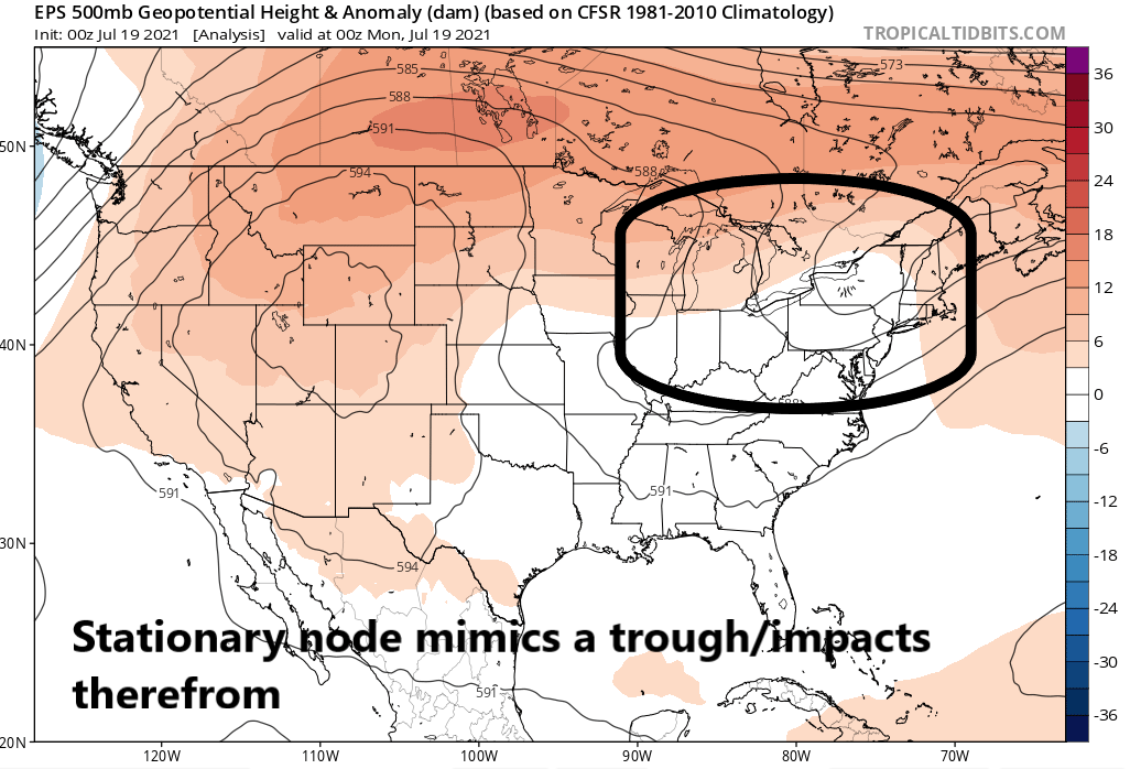
I was reticent to involve in the whole 'worst summer of all time' narrative that emerged like mushrooms out of the disenchanted peat ... But, I'm willing to nod to the notion of it this claiming July. And I did not see this happening - not even remotely really. It seems this murk we are experiencing in abundance over the last two weeks is a node between WAR and western N/A excessively expressing +PNAP. This has been in situ really since the big-like heat of the last week of June broke, we've been struggling to get away from this, but ultimately failing. At other times like yesterday and this morning, "submerged" in it is apropos! PNAP means "perennial north American pattern" in this context, which is not the same as PNA, or Pacific -North American. The perennial, or 'baseline' climate circulation mode over north America features a modest ridge bulge over the west, and a sort of asymptotic slope into an exit nadir over the Atlantic. Since roughly July 1 that has been in an exaggerated structure, regardless of the PNA, which was in both positive and negative modes, yet this +PNAP anomaly persisted through either. But, consequentially, we seem to have wound up in a neggie node here. This whole trough ordeal is really more like a weakness than a trough. In fact, looking at the ensemble initialization of either the EPS, GEFs, or GEPs ... we are in a ubiquitous neutral to positive anomaly in the non-hydrostatic heights everywhere over mid latitudes of N/A during this last 5 days. Yet, we are getting all this disproportionately persisting sludge parked specifically right here. The circulation around this region at times seems quick ... but the axis of it, itself, has moved some 300 naut miles ...or about 5 deg of longitude, in 72 hours! That's a planetary fixed feature. I am not sure if that is going to be the rest of the summer. It may. I don't know. But it is and has been the present 10 day to 2-week predicament of semi-persistence, having replaced the cyclic positive anomalies of June. Re that: there were four definitive ridge anomalies in the east from mid to late May to the end of June, and so far, none in July - at least that I can recall. I have seen them modeled, yup - but then within a couple .. few cycles, the structures always just collapsed back to this or variations of this, above. Be that as it may, tomorrow is a sneaking huge day-to-day change. That's the other aspect about this. We are managing to put together some really impressive intra-weekly temperature changes somehow by way of having this look in the means, when none of it has really been CAA transporting - by nature of the 'fake' or faux mechanics of it.

-
Maybe this was the genius of the cabals intent and design all along ... built into their formulaic 'population correction model' Half the people walking the planet and carrying signs at Trump rallies appear unable, either way ... struggle with inability to be owners of the brain boxes that evolution provided them, and refuse 'the cure'. The cabal created a Darwinian correction model that mechanically needs these types to work. Yeah ... that's saving the planet what ? 3 or even 5 billion in carbon integrated per capita right there. F'n morons..
-
Heh... the religiosity shit is tongue-in cheek ( sorta). The main point is the catch-22 ... Probably just explains that "Fermi Paradox" stuff ... it's all out there. It's not novel thinking here. As far as god: I'm not personally willing to ascribe to any religious doctrine - ever... Human profundity is too shallow to plumb the infinite requirement in depth where any such truth is - maybe that is heaven (or hell). Maybe not. It is inherently a paradoxical/contradiction of terms that any doctrine born from that capacity can thus be able to see in and espouse "truth" ... That's like asking a Chimpanzee to reconcile the two fundamental pillars of physics, QM and GR But as that abstractly suggests, it does leave open possibilities? At least that's what I mean. Part of the problem with Science is that it cannot ultimately rule out the possibility that some sort of super construct ( agency ...'god' .. whatever) isn't responsible for the Cosmos and the reality it contains. In fact, the rules of science are IN said Cosmos and its reality, so, if there is a god, god is responsible. That's just logic. Anyway, long of the short ... I'm amenable to the notion of some sort of super-sense that transcends the limited scope of Human math and science and empirical perceptions might some how tie-in meaning to all this, but I am equally open to the notion that there isn't either. But I personally do not believe whatever that is, is contained in any human systemic definition.
-
Nah, it is far more likely their society suffered the same Universal kill-switch that will inevitably befall Humanity, too. They managed to trip the switch and cease to exist, long before ever reaching the necessary god-like technological achievement to make passive or silent co-invasive habitation, or even just observance, possible. I know.. I know. What about the Drake Equation this, or 'if it happened once it happens all the time' that - The problem with "Drake equation" is that it's mathematics is too argumentative to be ... a mathematical description. Not for what it espouses to, or attempts to describe. No. It misses destructive interference factors, or 'denominator mechanics'. Like, it needs to multiply that entire sequence of products by empirically derived/observable time bombs. 1/ ( ... reason to fail and die), relevant to every individual term. As for the, 'it happens once...' narrative - it hasn't actually happened even once. Dreary assessment of Humanity's fate aside ... despite any conceptions in conceit of whatever it is we think we are of our selves, ... we ain't it. We are a stage 0 civilization on the 1 to 5 scale of advance. Yup ...we don't even register in the competition - probably because we consider it a competition for starters. Reasons to fail and end timelines get thrown at civilizations. It appears to be built in. Those that are 'up and comers,' they all must experiment through their own evolutionary process, shedding primitive ambitions 'just in time' before mixing those motivation with incredible power. That is probably a good denominator for that L term in Drakes interminable optimism... But therein is a huge catch-22. As the power to advance up the scale is achieved, that means a given civilization survived the failures. Evolution is an iterative experimental journey - inherently, that cannot be otherwise. A failure at incomprehensible scales of power becomes intrinsically self-annihilating, long before the infinity can be contained. There is a bottle-neck of "forgiveness" that ends up too narrow to allow the advance beyond a certain point. This appears to be some sort of a Universal modulator or "stop control," a universal "kill switch" ( think there is a sci fi book called that). For lack of better whimsy, a cosmological constant of death lurks in the destiny formula of all sufficiently advancing civilities. One of the notes in the music is wired with a detonator, just waiting to resolve at some point along the Grand Staff. It's just a matter of time before the term or factor is struck, - poof Why is it there? Who knows. Perhaps it is there by design. Huh. Like by an ego-centric agency ... to prevent competition from below, while protecting their anonymity. I like that, actually. Because it is very human. Butchering the Catholic Bible ... 'We are materialized from the dust; and to the dust we shall return' - I am not religious. It seems apropos is all... but that of the cosmos, we therefore probably share something in common with it. Maybe all we are is an excessively primitive variation of the greatest fault there is: God
-
That looks like Belchertown got water boarded again
-
No I think that’s too quick of an assessment just imho - Although in your defense it took Jason Varitek slapping Alexander Rodriguez in the head in August 2004 to turn that season around. By the way I’m diggin A-rod as a game guy. I think he does an even unbiased gig
-
Not sure why anyone feels they need expend any energy trying to disqualify what I said about the MLB game/shooting the shooting is the point; if there was no game would there have been a shooting? Probably not if we’re realistic - there’s no other point. In the stadium outside the stadium who the f cares it happened at a game. Too close
-
In the grand scheme of things it was right next door -sorry And ease off the regulatory committee yeah? It was hyperbole -obviously Point was cut in to convey that dystopian information in the middle that other BS going on - it was about the omen and homage Aside from the fact that whether it was at the stadium or in the stadium it was still at the MLB game
-
I know it It's been weird. I really don't recall a single BD in April that really could qualitatively be one, and maybe vaguely one in May. June maybe but it was so overwhelmingly warm if not hot, it really if so its not the same as this - not even close all three of those months put together. There's been at least five acceleration events like what you see there on the vis imagery ... https://weather.cod.edu/satrad/?parms=local-Rhode_Island-02-24-1-100-1&checked=map&colorbar=undefined The weird part about it it? There's no S/W moving SE out of Ontario. Heights are 582 godDAM NE of Caribou. It's almost the weight of cooler saturated air alone that's doing this. That boundary is moving unusually slowly too - creeping
-
This particular series between the Yankees and 'Sox is such a train wreck. how many bad omens are gonna half to be dodged to make this happen? LOL COVID cancelling games. Games that should not have been played, ... played deliberately long enough to tee up a couple of phat pitches down Broadway at precisely the right amount time in order "legalize" a win in favor of the demographic team, that also happens to desperately need a win to save a season they should really be selling off.. ? Umpires clearly biased ... And if the spectacle of it it all wasn't looking egregious enough, the taste getting any tackier, they were doing cut-ins to inform us that at a stadium next door there was actually gun play at another MLB game. Making America great again. Lol Sometimes I think it's just time to stop forcing it. They shouldn't' have played last night, either. Tough shit. It's called a day-night double header later in August. It happens. but enter the manipulation-force reason here [ ]
-
You can see this warm front just reversed and became a BD collapsing back SW of Boston as an undercutting on vis loop - that's ball game on Sunday July 18, 2021 for eastern zones.
-
Lol, ... now, we had/are having a summer - but I get the sarcasm. Like we said, it's just "too early" ... I mean it's more likely those 75 to 100 kt mid level streams up there relax some as that gets closer. But the technology manifold/physics tends to do this from time to time? It's like there are background forces, but the more realized wave structures/mechanics are masking. They are long term oscillatory aspects, and way out in time the models may loose the present more realized forces do canceling interactive noise, and when they cancel out ... it leaves the long term aspect to "coax the flow orientation" so to speak. It really is like revealing where it wants to go? I think it's fascinating. It reminds me of 'rogue wave' physics in the open seas. You /we know those are ... But they set up because of two physical processes: linear or non-linear wave mechanics. The first of the two, linear is easy. Wave A --> <-- Wave B = huge C because they super impose their wave energy. That is linear constructive interference. Non-linear is when you have 2ndary and tertiary residual interference patterns that can cause the rogue wave to seemingly lurch up out of the surrounding tumult some towering amplitude too far about the mean distribution of wave amplitude to be explained by any observable interference patterns. It's almost like this same thing happens in the atmosphere. Sometimes you have Alberta Clipper diving down the flow, and you have a southern stream wet juicy wave turning the corner. That's easy ... linear wave intererence leads to bomb. Rogue-ish event due to constructive interference. Then you have "teleconnector convergence" - a phrase I coined years ago because I am a loser with no life and think about this shit. oy.. But, Indian Ocean index ( say ..) sends a signal to the Del Marva, circuited through a favorable ENSO/ --> MJO transitioning. Meanwhile, the polar region happens to be setting up a -EPO ..which is not really dependent upon that array of former larger scale factors. Either one of which could favor a storm, but when you couple them together there is a "synergistic" aspect that enhances the favorability - "favorability" in this context just means the ability to dampen interfering factors in lieu of the dominating force - which happens to be the Cleveland Superbomb ...Or 1992 Dec ...or March 1993... Feb 1978...etc.
-
Oh so close! ugh I just looked at hi res sat loop (vis) and you can see where the warm boundary is - right along the Pike, maaybe 10 mi N. Anywhere N of that ~ W-E axis is butt packed in mid 60s drizzle and dead air. Hard to say if it lifts any further N but I'm suspecting/wondering if it's pinned. There is a cyclonic rotation to the cloud field over eastern PA - warm boundaries seldom arc N of cyclone latitudes in SNE - that's like physically insulting to classical mechanics or something lol S.. probably makes 83/76 just before streams take out more neighborhoods... Noticing also the GFS is already attempting to speed up the hemisphere and establish rudimentary R-w signatures .... Oh, here it is, 10 minutes past the f'n solstice and the GFS already thinks it's October. It's done this the last five years ... mid July and suddenly it has screaming 500 mb polar jet through 55 N in Canada by August 1. But here's the thing ... it has the right idea - it does. It's just too early. I mean there is a reason we have observed so many October snow and/or snow -supportive CAA events prior to Halloween through Thanks giggedy. It's because the HC is pressing into the lower Ferril latitudes ... --> This increase the ambient gradient at mid and upper levels of the mid latitudes --> Speeds up the wind field ( balanced geostrophic gradient ) --> Increase wind velocity then triggers large scale mechanical wave responses... --> The wave positions around the hemisphere will situate according to the same laws that govern how they do so in February; it does not matter. They don't change just because this whole process, consequentially occurs earlier and earlier in warm seasons. So, you end up with some sort of highly amplified, albeit strangely early hemisphere CAA events. (Keeping in mind .. this pertains to how CC effects the circulation modes over North America) Viola... Snow on October 15 thru Dec 1 happens, more frequently then before; the HC expansion counter intuitive response. But it doesn't last ... Because that gradient becomes so excessive in winter that the R wave distribution becomes mobile and also compressed... so you really get exotic extremes and whole lot of interference patterns ... usually more negative than positive.
-
LOL altho we're actually sorta kinda missing out here I'm noticing. Oh, our hydro's up - no question. But we aren't topping ponds over adjacent fields, and town streams and brooks are just healthy flows. In fact, the Nashua rivers still pretty much in its banks. I'll probably dweeb check it later - it flows 2.5 miles from my house. Muse: this area of Nashoba Valley is an effluvial plain. I was told that by civil engineers/geologists when came down our neighborhood drilling core samples over concerns for Arsenic contamination run-off from the old Fort Devans military landfill. Apparently they were hitting strata of sand and pete-debris ...sedimentary layers that are some inches thick and could only be that massive if there was some kind of catastrophic thing. 20 feet deep super lake here. Probably needs 300" snow year ending with 90 F heat and a typhoon in March some how some way... lol Anyway, I'm willing to hunch that the 10 day cumulative has a relative min in this region of N. Middlesex Co.
-
Apparently .. "verdugo" is a little bit 'dizzy' about ethics, huh -
-
Right... so that we can bubble up another 2 or 3" road eroders
-
I bet some sort of a scenario-scaled 'attribution study' or science would evince this 'wet 10 days' as physically connected to CC. Looking at these guidance initializations, ... regardless of which, the non-hydrostatic height signatures do not support this incredible output. 582 trough? trough! ...we've had temps in the high 90s with open blue sky in that height. Heights in the western N/A coupled balance are only 594 - impressive in the scalar value, but not in the field differentials. 580 height nadirs with a single isohyspes circumnavigating, nested inside 588 mean domain depth: That is simple lacking mechanics to product rain output at this mass loading. I really believe the culprit from any said study would likely expose: a weak systemic triggering + excessive PWAT. You get "synergistic" feed backs ( so to speak) where results tend to go beyond predictive modeling. Larger PWAT in the ambience is one of the most consistently recurring consequence that "precipitates" ( haha) out of climate change modeling
-
mm ...hunch and personal relationship with modernity : I suggest that era-relative sociodynamic mechanisms are only similar - for one... the frequency is up ( delta(dykhead) is +, and that is an acceleration in the collapse of civility ). The only thing consistent with the two in comparing gestalts is that yeah ...assholes exist in both realms. But that's as far as the similarities go - lol, just leavin' it at that
-
Heh … unfortunately, not for the same reason.
-
Societal morays and restraint approaching critical We’re getting shootings at MLB games now too according to that cut in ? Okay Meanwhile at this Red Sox game a yankee fans throwing at actual players …. brazen acts that just simply didn’t take place prior generations - I wonder if gun play at a fcking MLB game is enough cause a league stoppage for awhile.