


Typhoon Tip
-
Posts
44,834 -
Joined
-
Last visited
Content Type
Profiles
Blogs
Forums
American Weather
Media Demo
Store
Gallery
Everything posted by Typhoon Tip
-
bullish on the intensity forecast .. now lower category 5 by tuesday evening right now on ir the eye has the dreaded pin-prick look - not sure what the dimensions really are. it may just be an artifact nuance but in and of itself the teeny eye axis surrounded by -90c ring has been noted of very deep bombs. think wilma -
-
milton 125 mph 945 mb ... drop 9 mb! special advisory posted... ri underway
-
sort of a warm/cool tussle going on in the guidance after mid week tho. the higher latitude indices are in a warm phase. the pna is in positive mode. ...and the operational guidances are yo-yoing the pattern across the continent about evenly between which one of those larger scaled circumstances will proxy our daily weather from roughly the 10th -20th
-
watch the mid week cool pop end up so windy that last night is the coolest night in the stretch lol not sayn that's happening just that it'd be apropos for climate-any-excuse-to-not-be-as-cold-as-guidance-complexion-change
-
still thinking frost or near frost mid week, but we may regress back to a warm up thereafter ... it's difficult with conflicting upstream signals but the wpo/epo is warm mid month and the ao/nao are creeping positive... yet the pna is stubbornly positive. not sure how that's going force the dailies - the wave lengths aren't quite long yet. it's interesting that we're seeing those cold meanders though.
-
interesting ... it would be about 14 years again until a real october snow either would or chance take place in the general ne ... and since, about 1/2 the years in the last 22 of them have carried that as an at minimum threat if not realization.
-
well like i was telling Ray a moon or two ago ... there's nothing about the entirety of the state of the climate ( yet ) that suggests a 2015 february can't redux. even 50% of a redux would be a crushing win over these last 7 inches ... uh, i mean years of winters we've been boned by whether the indices align or not ...that's what i'm personally wondering. we may get more of the idiosyncratic or incongruous events from the excessive variability, week to week. heh ... could get the winter quota in 3 storms over 10 days and we're back to cargo shorts
-
i like how the bay area of san francisco got whacked by 90+ heat. it's very hard to do that there. that w--> e replacement flow through the golden gate straight is very difficult to stop and takes some pretty amazing circumstances to stop it. i've been out there when it was 101 on the eastern shore of the bay and we couldn't get over 70 down by the marina district. on the other side of the penn on the pac side it's in the 60s with pants flapping in the crushing onshore laminar flow. yet i think they've been close to 80 on the sand in this thing
-
a problem with this is idea above is considering the quasi decoupled tendencies. global patterns appear at times disconnected from enso forcing. this can happen at any time, ..depending on the total integral of influences, usually more transient. but the observations of it have been increasing over the last 10 years with some times even nino modes showing up during and post ninas and vice versa. if 'la nada' prevails this ensuing season, it seems logical that these notable excursion tendencies may also factor and screw up inferred models there, too
-
research is nearing the codification of a new enso mode ... 'la neutered' ...it's basically huge negative/positive departures, while the wholesale surrounding global medium behaves like which ever it is, it's completely ballless to motivate any response at all
-
i suspect what he meant was ... 'when was the last time all three months were individually below average' i don't mean to speak for torch tiger and i may not be right about that, but just in general ... often times in common vernacular folks will confuse aggregate vs qualitative
-
it's not very often you see a cool front approaching with a ne wind out ahead of it
-
check out this la la range euro solution. impressive 850 mb thermal spread n-s through the continent. it looks like a one of those early heat expulsions you get in april.
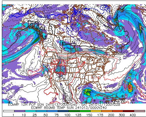
-
heh ... considering that the whole world put up the 2nd warmest sep in history ... not sure we can say 'due to +epo' as the singular cause for that but yeah, it wasn't hurting to have the pacific signal as such
-
it'll be less than that unfortunately for cold enthusiasts.
-
tough to argue
-
Occasional Thoughts on Climate Change
Typhoon Tip replied to donsutherland1's topic in Climate Change
https://www.nature.com/articles/s43247-024-01661-8 -
it's a'ight ... it's just been a long while since anyone's given ww's chode hairs a tug so felt morally obligated -
-
the thought had crossed my mind ..but i really suspect that's a standing order every autumn during this particular era of cc - yeah ...it's related to that forcing so anyone that wants to roll their eyes can summarily go f themselves. sick of dancing around other people's denial with diplomacy while the world races to the cliff -
-
+pna/-nao continues in both the production version/means, and the ensemble-based teleconnectors. interesting that the pac is stuck in that +wpo/+epo while the above persists. anyway ... the gfs (operational) is trying to sell 'blue' thickness intrusion/oscillatory pattern ... beginning by the end of the week. frost(s) would like take place on any interim night in that regime between ~ 9th and the 16th. the tendency to over exemplify base patterns in that time range, notwithstanding.
-
may not be appropriate for this thread ? japan set the 2nd warmest september since records began back in 1898 according to the meteorological agency. "But some regions, including eastern and western parts of mainland Japan, logged the highest ever average temperatures for September since comparable data began available in 1946, the agency added." given to the damning global surgence of warmer than normal just about anything that can be defined, i feel that cited statement is probably more important than the fact that this particular september was "only" the 2nd warmest ever. a completely chaotic timed cloudy day comes along enough to hide a 10th of a degree and we're enabling deniers - ( https://phys.org/news/2024-10-japan-hottest-september.html )
-
the article contains a broader perspective but just wrt to the bold above: yup... i've been writing about this phenomenon - or trying to raise attention - as to the 'synergistic heat wave' one in the same. you get some kind of harmonic feedback from the environment that is also not very well understood and/or not necessarily built into the modeling/leading indicators ... boom! the event exceeds expectations. but i also believe it is not just feed back from the physical enviroment, but i also see atmospheric harmonics taking place too. like rogue waves in the ocean as analogy, where multi scaled waves come into a constructive interference - the degree of amplitude tends arrive large and there goes edmond fitzgerald.
-
https://phys.org/news/2024-10-helene-storms-dumped-whopping-trillion.html
-
Occasional Thoughts on Climate Change
Typhoon Tip replied to donsutherland1's topic in Climate Change
https://phys.org/news/2024-09-anthropocene-1950s.html ( https://www.pnas.org/doi/full/10.1073/pnas.2313098121 ) -
yet at the same time ... we're working thru a 3rd consecutive week of ne-e flow fisting sw out of a -nao (western limb) something like 90 percent of the time. even when the nao block waned during that time range ... some pos front or worthless decaying tropical garbage sw-s keeps the e flow active. it's a local eastern n/a effect that's making it 'seem' more autumn like but it's (typical for this region) fake i guess what i'm bitching about is that 850 thermal mean through this period would have led to sfc summer appeal the whole way if we could buy a f'n coffee break of wsw wind and minimum sun




