Typhoon Tip
-
Posts
44,532 -
Joined
-
Last visited
Content Type
Profiles
Blogs
Forums
American Weather
Media Demo
Store
Gallery
Everything posted by Typhoon Tip
-
some are seeing today and getting carried away
-
yeah... i'm like, what?
-
well anyway. gfs has been attempting to foil warm ridges since 2015.. lol it's just that it's really unstable with warm patterns - it sputters with them. it's far more stable with cold/-EPO looks though. not sure why.
-
meanwhile,
-
ah yes. the coveted 'front loaded' winter. man, the last one of those ... Decembers of 2008 - 2010 ... ? i think it's been that long. mostly the winters have just been a game of breaking continuity but these cold intrusions don't even seem to be connected to the winter basal state, which comes in later. and when it does, it seems to lack l/w residence with quicker pattern turn overs, and also higher base velocities in the physical wind. folks should read papers like this ( no you per se ...just in general) https://phys.org/news/2023-12-jet-stream-faster-climate.html
-
it's the other way around most likely. but .. like i said, chicken or egg. i suggest the egg is CC ... and just like the gom and adjacent sw atl basin is also an inferno, so to has this accumulated in the sw-w Pac. it's just that the west pac is larger unobstructed expanse so is larger and more looming, but in either case...
-
it's not driving the walker cells.
-
although we've been observing cryo supporting and/or snow achieving air masses in half of the octobers since 2010, despite the -pdo. not sure these have extended down into the m/a.. but there's clearly been a shift toward buckling the patterns and sending cold anomalies under roll-over/ higher latitude u/a warm nodes and causing new england cold bursts earlier. interesting. thing is, they're not like persistent. they're in and out in 7 days, the month sometimes still end up above normal by a tick or two.
-
where's that coming from ? i've not seen any refereed material on that aspect. speculation: that is there as a cumulative effect of sea-surface stressing coming from the surrounding hemispheric mode(s) over the last 5-7 years. could be a chicken and egg thing, but i think of it as a 'barometer' ( ha ) of the times, more so than a driver.
-
again, an early winter showing wouldn't surprise me though... lol if november 14 through dec 10's or something is the best winter expression
-
okay, at risk of being sucked in - which i won't let myself... i'll just say, if it ends up within .5 of neutral anyway, logic dictates lowering relevancy when in that n/s range...
-
gfs' plot to negate any warm up in a week is almost complete, too.
-
yup, an early autumnal vibe. particularly when the sun slips behind one of those 20 minute pancakes - circa september 24thish
-
okay... i guess i'm describing more so a pathway to winter sucking giant donkey balls, and why ? i'm not in any kind of argument over whether the hemsiphere resembles whatever wrt to enso.
-
i suspect the enso will be too weak to matter against the din of these overwhelming other aspects. not much else. the ao being preponderantly positive is a bigger issue for me, as well. if so ( and it is robustly correlated to be ... ) it would be in a constructive interference with other mitigating stuff, muting enso forcing even more. i said the -enso may turn out weaker - i meant so on its own. but that's also hurting it's case as an exerting influence, granted - i'm not obfuscating anything - i'm just not considering any of that noise as factoring enough over the louder indicators. the hemisphere's destined to be velocity soaked and stressing telecon correlations - this is also being papered. I don't have a problem with those publications because matter of fact ...i've been railing about this since 2010
-
MJO desk: • During the past 2 weeks, the RMM-based MJO signal has increased in amplitude and is now located over the Indian Ocean (Phase 2). • Dynamical models are in good agreement regarding enhanced MJO activity across the Indian Ocean and Maritime Continent during the next 2 weeks. • The MJO propagation across the Indian Ocean and Maritime Continent supports an enhanced easterly wave train coming off of Africa in late August into early September. • Combined with anomalously warm SSTs, and the approaching climatological peak of hurricane season, this favors high chances for tropical cyclone (TC) development over the Atlantic Main Development Region despite the suppressed convective pattern aloft.
-
yeah, like that
-
yo Brian ... you might find this interesting. or not. but we were wondering if smoke particulates entrained into rain mechanics may also goose rain. " Pollution acts as cloud nuclei. " https://phys.org/news/2024-08-year-air-pollution-thunderstorm-danger.html very closely related -
-
i've noticed the gfs has actually not completely sucked pieces of cat shit when it comes to targeting genesis. i haven't looked very closely at it - could be it just happened to score when i checked so ...this opinion doesn't mean anything ... but, have noticed it enough that it seemed okay relative to having no clue at all
-
but i'd be willing to suggest an early winter event from late oct - mid dec, prior to the gradient lock down prison. then again perhaps late when relaxation teams up with cold meanders in the spring.
-
y'all can simplify a lot of stuff going into this seasonal outlook hobby - at least on my desk. summer and autumn solar demos a robust lag correlation to ao during ensuing winter. +solar = +ao -solar = -ao ...to me, we are looking at a +ao winter when factoring in that no formal prediction source saw the highest solar active max in over 20 years, and in fact, thought the opposite prior to this rage. heh. that, together with preexisting ( decadal recency ) to observe + as the dominant mode, anyway, +ao seems academic in this case. +ao winters are not summarily ruled out in 1990 securing d-drip doses in 2024? gets a bit 'shakier' we're gonna have to lop this attribution shit ( which is unfortunately real shit) on top of the former statistic. as to the lower and mid latitudes, it seems to me this la nina is either weaker in general , or made less effectual anyway, because like all ensos of the last 20 years ... they've been manifesting lesser responses ( i didn't say zero ). again, i believe they are getting buried/overwhelmed. it's been my own take on that for years. since, this roni business has emerged and well there you go. it's getting arithmetic for me. la nada-relative hemisphere pretty much leaves the dominating mode to the attribution stuff, which is a gradient rich, higher speed sheary shit show, taking place under a +ao. should all = a low scoring winter from winter enthusiast side of grading, to put it nicely
-
KWO ? ...is that a radio station
-
welp ...that 'bout wraps it up for 2024
-
sun is april 20-like .. still warm enough to heat things up. 850's appear to +6 to 8c-ish, which if we mixed that high and actually get more sun we could still 72 or so down here along the cp. probably won't mix that high but it doesn't matter because the atm is adiabatically stable, so 900 or 850 probably ends up with similar sfc ranges. a NW d-slope trajectory not hurting.
-
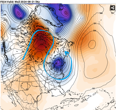
it's the continental folding over pattern causing premature cold meanders ... i used to conceptual post about it but stopped last year when i realized the room is empty. but it's a thing we've been observing more and more so over the last 10 to 15 years. this ... is really a manifestation of the same thing as far as I can tell - it's just doing so 45 days early. But that deep anomaly is an 'atmospheric meander' - it's been papered as an increasing phenomenon associated with CC connection to pattern morphology... blah blah. but this little cool thing as you can see above, is almost disconnected from the prevailing hemispheric footprint there. It's actually put there by the folding over +anomaly over central Canada. clearly what this is... attribution --> cold piece of shit imagine this were October 15 ? this is how we've been getting these October/Halloween snow airs if not actually snowing.