Typhoon Tip
-
Posts
44,532 -
Joined
-
Last visited
Content Type
Profiles
Blogs
Forums
American Weather
Media Demo
Store
Gallery
Everything posted by Typhoon Tip
-
An aspect I noticed about this season along these prior months is that it's seemed like low frequency TW - or maybe the coherence is just low. But it's been like low motility counts. lol Having said that, running the models out in time from this point forward, ...there are 3 to 5 identifiable waves emerging from Africa down there so perhaps the MDR will light up for a while. The MJO desks/publication suggests both that to go along with the obvious climo.
-
I would go further and say that the protohominin leap in intelligence required that for survival. Physically, our brains become expensive ( except for Kevin ... ) and hat expense required trading brawn - think of a new born calf in the plains of Africa: within hours, runs as fast as the parents to escape predation. Human can never do that ... We are not born 70 .. 80 .. 90% ready for the Darwinian war. We are helpless. Thus, our advantage arrived through cooperation among a community's members living in vital recognition of one another - love and appreciation and the broader spectrum of intangible intelligence came along in that era. This sheltered and allowed our brains the time it takes to mature to adulthood; which in totality also takes much, much longer. But, long before we ever reach adulthood we are already conceptualizing aspects that no other animal on this planet is capable to doing. The requirement of social intelligence was quite likely, much deeper ingrained as an instinctual imperative, one that even psychobabble -sciences I sometimes question whether they 'get it'. What the advantages of the 'industrial bubble' (modern tech and 'blue screen' is just a part of the bigger picture) is doing is isolating human beings. Disconnecting that deeper rooted codependent sense of belonging that always kept the pack vital. It really is an evolutionary gate ( I believe ...). We are living in a leap era. I believe that. The last 200 years since the Industrial Revolution have been both quantitative and qualitatively transformative, more so than the previous 200,000 years. 200 ... 200,000. The human socio-technological experiment.
-
I’m no sociologist but agreed … Ive been railing OTs about this subject matter for years. There is a lot of codified science about the dimming of the intellectual pool, both in higher mental functions as well as the moral and virtuosity aspects of the total cerebral spectrum … do to “blue light” exposure Humanity is passing thru a great socio-technological experiment at an evolutionary scale
-
It's gonna do that willingness often through Feb 15 ...then, when the sun starts coming back next spring ... ignore said sun and keep doing that before admitting for 20 minutes toward the end of next June that it's actually summer. Struggling to admit that circumstantial reality ... it labors thru July and then next August, weiner runs start pumpin' out all over again
-
It's hypothesis but, I'm curious whether the reduction in sulfur emissions, 2023, may be related. Sulfur is tricky. It's more like an indirect greenhouse gas by effecting reactions with those compounds that are more or less efficient GH. But it's complex, because stand alone, it is both effecting warming by direct absorption, but also cools for reflecting sun light in clouds. Those latter capacities are not constant either. There are circumstances when d(more or less) LWR is being absorbed, and d(more or less) sun is being reflected. We know sulfur in the stratosphere is a solar reflector, but sulfur in the troposphere... particularly below mid levels, I "think" is both reflecting in cloud droplets, and absorber when in free air. In either case, the rather abrupt abeyance of emissions - if measured to be effectively significant enough - might move the EEI numbers.
-
Another night of perfectly average lows around here. Nice 57 High is projected to be average-ish. which together with low RH and purity of sky makes for a top 10er day in mid August.
-
tropical storm, eh
-
When you cross up the idea of Chamber Of Commerce air quality control environments with the awe-inspiring intelligentsia of the cackling plebeian user state ...
-
Ray can bun you but if it's worth anything, I noticed this myself. But, I didn't notice it as 'only the GFS' doing this. I thought they all were doing a "relay capture," where a mere weakness ( yes ...some models more coherenly demo this than other ) initiates the N bias to the track, and then 500 mb carving out a saddle tough to the N is just too much to resists and it's next stop Ireland. I've seen that happen circumstantially over the years...It's a valid interaction. However, there are reasons to question that. For one, the interaction between the weakness and the fledgling TC is complex and may be that way. Secondly, the 500 mb trough that does the final capture could be a touch over -amplified. I've been railing on about the models having amplitude biases, particularly the GFS, in the late mids and ext ranges for years. I don't see any indication yet of that bias no longer being the case. It's particularly true in the winters - not as sure in their handling of summer hemispheres. None of this above is intended to insinuate increased chances of this thing making to the Americas. just some observations I've been making re the mode of the SW Atlantic
-
Did 27 holes of Golf yesterday amid 81/54 ... not that anyone should care, but for me this is okay vacation weather. It's amenable to actually being outdoors engaging life. I don't like DP elevation just for the sake of them being high, unless special circumstance. But, seein' as that's part of life, the next best thing is not to have elevated DPs, not while any temperature is above about 75.. 75 / ~ 67 is the cut off. Anything above that gets sensibly stressful - slow cook at first but low air flow 85/ 70 with any kind of sun gets irritable pretty quickly. I guess some hypocrisy here, DP can actually have its place in a narrow gap between 75/72 ... particularly if there's a breeze, and tropical turrets going by. In fact, if the breeze is active and these bee-bee convection cycle over head to offer shade moments, the Bahama Blue thing we mention has some appeal. I just don't find any use for 88+/67 under unrelenting sun and hazy blue searing sky, with light or no wind. It's no different in terms of annoyance's scalar value, to being 43 with zero snow chances and nothing on the ground in January. Actually, snow or no snow, 43 F winters can go f themselves. I've come to find my favorite is right around 86 / low DP, though. Warm and dry. Not hot and dry, with splashes of sun after reprieving shade by passing fair weather clouds and/or trips under trees is ... And please, no f'ing smoke!
-
Where I am here, last night's low was 58 ( 57.7) That looks to be about as close to pin pointing the climate average as a chaotic world is capable. Not intending to gaslight, but ... I almost wonder if the "cool" characterization is more of acclimation thing. Cool requires a negative departure. Lol. Fair enough ... I mean, if it hasn't "fallen" to average in a long enough time. There's climate and then there's sensible appeal. I thought it was interesting that we had a radiator night just in general. I can recall in the years back whence ( slow rocking chair with ribbons of pipe smoke risin' ), we would get these radiator nights going by mid August. However, those would be more like 50 - it's like we're conserving that behavior, but at a loftier scale. It's almost like radiational cooling nights used to be 52, 42, 32, 22, spanning Aug thru Nov.
-
It's well known that the northern Polar regions have been warming at something like 2.5X the global rate in the ongoing CC monitoring. I wanna say I read recently, that's been corrected even more so. However, the cause of which is still being studied as to why. Meanwhile, I keep seeing studies/articles similar to this: https://phys.org/news/2024-08-unexpectedly-large-methane-source-overlooked.html I've been wondering ... Perhaps it is the flux of C02 and/or Methane that is directly related to the arctic warming acceleration. It may be kind of ACME science sounding, but ... the PVs relative strength over the years might in fact trap lower tropospheric fluxes, particularly during positive phases of the AO. The idea there is that consequentially, elevating local Methane etc might trap might more heat ( relative to the trapped environment ). The reasoning there is admittedly perhaps an over simplification of a lot of complex processes and feed backs, both positive and negative therein... However, a positive AO tends to 'bottle' cold N; by physical constraint, the dispersion out of the arctic of cold is slowed during those phases. Wouldn't the dispersion of C02/Methane fluxes follow the air flow? The +AOs may not be homogenizing the arctic tropospheres with the global ambience ... outside the PV domain, as readily as it would during -AOs ... That's when conveyors that deliver cold to middle latitudes become established, being academic. In other words, positive feed back for warming might be circuited through the slower dispersion rate of out-gassing. Of course ...one would think with hundreds or even thousands of atmospheric accredited scientists working the CC-arctic, this has been thought of and/or papered by now. Haven't check. This could all be reinventing wheels. I checked the last 30 years, and the AO has been positive. A cursory evaluation of the coarse graphical product at CPC does suggest that the AO has been positive more than negative since 1990.
-
Augusts have changed over the course of my life. I remember as a child getting poked in bare feet trying to run through the back yard, because the grass dried out in August and turned beige. It would be more dry and with still lingering warm temperatures. Higher DPs seems like it's crept into the anticipation over the years. If we end up in one of those Bahaman stream line flow deals like yesterday... yeah that would happen from time to time.
-
Looks fake heh
-
Unless hgts begin to rise more over the maritime all you’re ever going to see from the models is tease after tease after tease …
-
I don’t think a 10/70 split’s all that great in bowling tho
-
-
OT: the reason power prices are elevated(ing)... not just in CT but everywhere, is claimed by "big power" to be caused by supply shortages relative to demand. Which is impossible to prove otherwise ... Op Ed: I don't believe this is really the case. I believe there are increasing numbers of state and federal rebate programs to get residence and commercial grid users to go toward more efficient energy consumption technology, as well going solar and green power generation options. The combination of rebates ( which can range from 5 to 20k dollars ) attracting this conversion ( primitive initiative in the combating of AGW as the grid is still largely powered by fossile fuels), and solar pay-outs from surplus ... are beginning to place economic pressure/losses on the glut machinery that they've always enjoyed. These are not socially owned power suppliers and delivery companies - they are still capitalistic enterprises. You cannot impose losses on them and expect them to not to respond in kind - they chalk up this impossible to prove bs when all they are really after is transferring those losses back onto anyone in the grid that is is still suckling from their teet. Or ... maybe they are truly virtuous and are doing this because they have huge hearts and care about Gaia, and it's got nothing to do with money ... so they are attempting to squeeze people that way to save the planet as the heroes Pick
-
dp might be inflated here by that 'warm' shower ...
-
same ... wind just picked up too a bit. jumped to 83/78 very Aruba like
-
last year I had a DP here of 80 on two separate occasions. it's 78/76 at the moment ... but yeah, right up there. we were 64/63 at dawn but as expected, warm frontal surging getting single pixel down pours. 30 seconds of water boarding rain rates then nothing
-
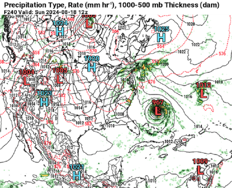
MDR is activating in time here ... said so myself earlier in the week, and probably so did others for their own methods. beyond that concept, meh. another 24 hours later, another 24 different ideas as to what that might mean out in space and time. yesterday at this time the larger scale 'cane climate aspects had trending favorably for EC ... 00z they look like dung... ( modeling on average). yet, this 12z GFS somehow manages to place a TC E of Jersey with 00z recognizable climate inference bottom line, no stock in any depictions beyond 120 hrs... maybe out to 168 but no agreed that it may not be the only system. the favorability for genesis probably last 7 to 10 days
-
Depends on the IOH ( integrate ocean heat ). You're right that cyclone trafficking across a given region will tend to cool the surface waters, but ... if the overturning is doing so through a deeper thermocline than naturally the overturned column will remain warmer.
-
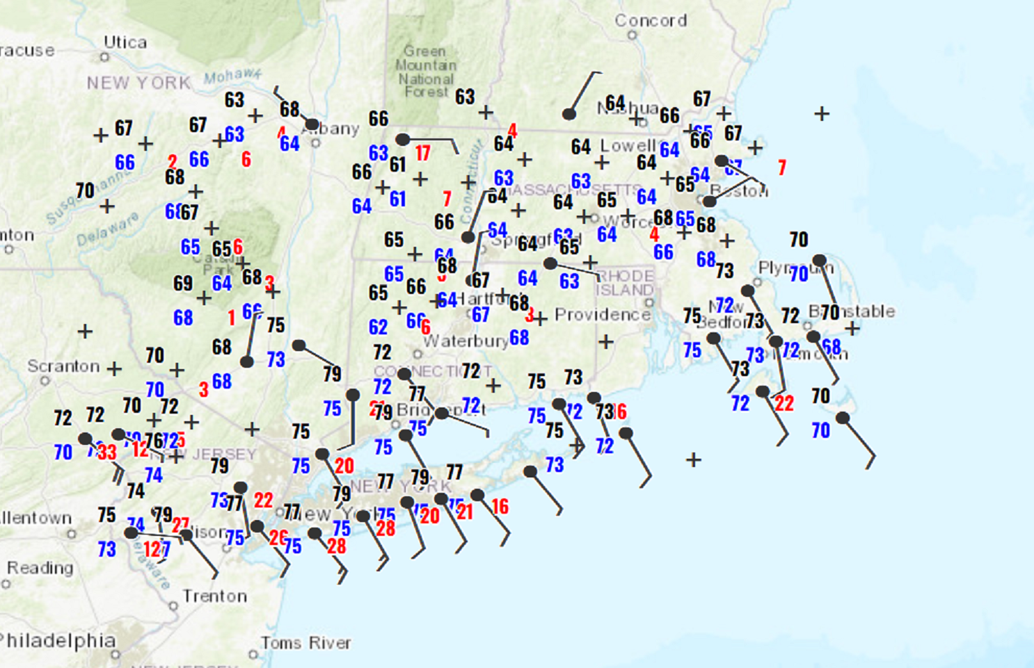
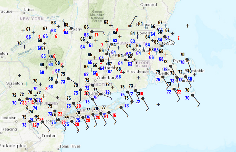
should be some impressive sensible differences coming in here today with this warm front poised to surge through
-
The headline zealots will love the 10 day Euro... ...setting us up to finally earn our own attribution badge ... actually, this could set up regardless to be fair. but that's like a 2 or 3 day easterly anomaly with tons of water, BEFORE a 'cane gets potentially sucked on in and up.