

Typhoon Tip
-
Posts
44,532 -
Joined
-
Last visited
Content Type
Profiles
Blogs
Forums
American Weather
Media Demo
Store
Gallery
Everything posted by Typhoon Tip
-
That looks like the new climate footprint: speed ..which is a crapse shoot that actually tends to roll pieces of shit more than not
-
We should also see an eastern continent/mid latitude ridging and warm intrusion, too. Could be the last heat wave chance of this season ...circa early next week. models are tepid on the idea ( operational ) but some of that ( the GFS in particular ) is native bias related.
-
Eventually it'll happen. March 2012(?) was something like a raging +10 to +15 above average. Doing that at a whole month's chunk of time is nothing shy of extraordinary - an achievement that I've always felt was way ...waaay under recognized, let alone even much talked about why? because +12 F in March does not appeal to any pain sensory in the common everyday experience enough to warrant a head's up. That's the biggest problem with CC and GW and AGW and whatever abbreviation of the moment suffices, is that it doesn't actually appeal to anyone's common experience - or never used to... Yeah, people are dying in swelter more frequently now, and along with other specters and popularizing dystopian headline attention grabbing is beginning ( finally! ) to appeal somewhat. People need punches in the noses leaving their house, with a burning bush and voice from the heavens claiming responsibility for the pain before they'll admit their about to die - Making America great again is impossible when there is no world within which to actually have an America - this will forever escape anyone's connective intelligence until they start to feel pain. Anyway, if March 2012 can do it... it's not a huge leap to back date that achievement to include Feb ... hell, it was 80 in Feb twice during the last 7 years, and 70+ in half of 'em as it is. Trade those weird week events for an aggregate there you go. ( the preceding is frustrated dark humor along with some seriousness )
-
No...it's not just you. heh. and yes to bold. I suspect ( not that you asked ... ) this is a "region of the continent" emerging problem? CT may be preferentially situated within that general dimension, but with the sample size not being very weighty yet, it may just be a CT fractal. ... VT also scoring. They're clearly headlining lately up that way, too with an increased frequency, so the distribution may have more than one nodal focus. I also suspect we have our own "attribution" aspect going on at a general scope. Time will tell if start seeing these hydro bombs going off outside CT and VT, but the Leominster 9" evening event along interior/Rt 2 thing just last year adds to the argument that there's broader perspective risk concern. All regions are susceptible imo. The ever usable 'just a matter of time' cliche is apropos. But, one can intuitively see why the CT-VT axis may also be more prone within the larger generality.. Wiz' and I were ruminating yesterday that this sort of thing is beyond the scope and capacity of modeling state of the art. I don't know how you can "see" a 10 to 15" hydro bomb before hand, when all of the mechanical players are under the floor of the model grids ?? It's a f-up circumstance to be in if we are going to be tip toeing blind through a Meteorological minefield.
-
The problem with Gloria is that the regional excitement leading ended up getting "screwed." It was akin to a giant blizzard forecast, where its in the headlines early ... say period 4 blizzard watches issued ( rare ), and then only getting 6-8" out of it with less wind. Good storm ...sure, but heh. Winter or Summer, that feeling of being gypped is the same. ..it weakened at a very rapid rate shortly after turning the corner ENE of the Bahamas. I think I read somewhere that it took 13 hours to move from roughly that latitude to it's landfall point - very fast forward motion if that's true. But I know that it dropped from a cat 3/4 all the way down to really barely a cat 1 as it was cutting up across western LI. It really was not 'as bad' as it theoretically could have been. A disappointment ( in the screwed sense ...) because Gloria spent time as a high end cat 4 as it was passing 70 W down there, and that really sent the headlining and the, at the time, primitive meme society into fever pitch. There were people taping windows around mid Middlesex Co, some 80 or 90 MI from the S coast. In retrospect, that was a combination of ignorance and celebrating the dystopia thrill. What we experienced in Acton, MA, surrounding communities, and most E of the track ( just W of HFD CT to RUT VT) were occasional gusts to 65 mph (ave), 35-ish sustained. These were not sparsely occurring 65ers, either. If you experienced Gloria over interior eastern SNE your neighborhoods likely heard Lockheed C-5 Galaxy class aeronautical engine tests, with embedded sounds of failing large timber, more than once or twice. Power outages were widespread. Most of the region described was in darkness that night and this lasted for up to a week in some areas. But, this was a high end Wind Warning scenario as it turned out, and does not really describe ( again ) what is theoretically possible - nor did it match very well what the expectations were made to be. For that, there are mixed opinions. This is all just the way I remember it for having experienced the full spectrum of a New England Express hurricane, from inception to event-post-mortem. Others may have more or less impacting memories - I don't mean to gaslight those experiences.
-
Mm. I think there’s some hoping for additional carnage and getting annoyed and googly eying people that see this as becoming less.
-
It’s S guys. lighter rains may be more slow moving rain raters tomorrow tho
-
Not that the LI Sound was any kind of paragon of angel tear water purity to begin with, but I wonder if there’ll be a measurable pollution spike from the effluvium this thing’s about to deliver it. Think of all that “fresh” humanity rushing into the sea there. From microplastics to blown out sewage cisterns … spiced with homeless corpses, may as well be a Fukushima discharge
-
Mm ..I understand the frustration. But, the vagaries of wind, and the weather that transpires because of it, that is not like controlling electrons along imprinted wafer chips and so forth - which is the technology you refer to when acknowledging 'life's advantages' for having access to it. Try to make this brief but, Quantum Computing technology has been recently proven possible, to the extent that it is actually almost ready to leave the lab and head to beta environments. People don't really grasp what Quantum Computing really is - it's difficult for the every day intellect to wrap their mind around that. Not saying that is you ...or any of the other of the best and brightest current readers ( ), but tech as we know it ( computation in computing) is still and always has been about faster and faster computing binary, 1 vs 0 ... On or off. Instructions carried about in dizzying speeds, granted - so fast that no one reading can really conceptualize how fast a terabyte of date done in a second really is.. QC doesn't run instructions to solve problems. QC knows all the possible answers. instantly. I just gave this rhetorical run-down to say ...maybe QC has an fantastic horizon in the field of spontaneity - to wit, the vagaries of the wind are so highly subjected to chaos. The spontaneous emergence, which has its horizon in the quantum field.
-
I don't yeah I'm not sure that's possible without some sort of innovative thinking ... maybe even savantistic special order insight. The present era of technology appears to be incapable. To many times these things are occurring where antecedent indicators were blind to them going off - all over the world with alarming increasing frequencies, involving not just rain. I mean weird wind. Strange atmospheric boogie man bullshit. These are blind shot events. Heh, sounds like a good intro to a sci fi. Only problem is, the proportions of that are essentially true. hahaha
-
-
sorry... I'm just a cave man and these common vernacularisms of typing escape me ... but 'ehhh' comes off as flippantly dismissive of people being shocked by this. Everyone very much should be shocked and appalled at a foot+ of zero notification explosions of water. I'm bustin ur balliez a little here .. but seriously, there's nothing about Friday that suggested anything like this. We seem to be in an era now where a whole dimension of atmospheric phenomenon can not be foreseen by this state of technology that's in place. fascinating
-
k.... no one gets credit for this, which transcends any indicators from last Friday. just so we're clear. you came in an meh'ed the fugger 2 hours ago and we may see 15+ in 6 hours here, and that's exceedingly rare. the point here is, these meso "bombs" are over performing relative to the phenomenon of "positive busts". There's something else going on...
-
Yeah ...the signal was clear that 14" of rain would happen... lol c'mon
-
Agreed ... I asked the question an hour ago if anyone had notice this: the "busts" behaviors are like over-achieving relative to bust phenomenon? It's like we used bust by doubles or triples. We've been seeing order of magnitude bombs going off - not exaggerating, objective numbers!
-
For those between Hartford and Water"buried" CT that are currently suffering a water deficit, you can feel much better about things as this is coming for tomorrow...
-
that's an interesting thought. I dunno. either way it was going to be a water boarding when there's a ESE/SE inflow from sfc to 850, while over top, a SW flow with an elevated PWAT anomaly. There's also a subtle yet discerned 300 mb jet acceleraton nosing across LI sound between 12z and 18z today, and that's going to physically enhance UVM along that axis right where we saw the training - makes sense there.
-
This ought set em up good and proper for those slow moving dam break cells tomorrow, eh?
-
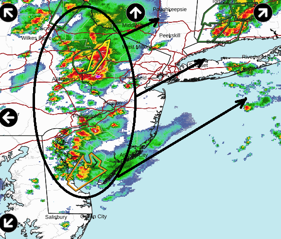
Poorly analyzed warm front situates through the area… Maybe at no-fault to the technology it’s diffused in nature, but it is allowing lift. If you look at the satellite, you can see that there’s a general motion of very warm, humid air coming from southwest and it’s lifting over the boundary.
-
there are other ways to do it. I’ve seen spring coastals lay down 4-6” at regional scales. 2010 Mar did three weekends in a row
-
Need a hurricane right side stroke to get that
-
anyone noticed that 'busts' lately are GInormous ... ? That's new. Used to be a forecast for 2-4" of snow ended up 8 to 10" Impressive enough. In 1997 1-3" of slop not only busted clear to 20", it did so with temperatures well below and too cold be qualified anywhere close slop. It was 26F in Acton and we got 16" ... 21" up here along Rt 2 from that. But that "kind" of over the top excessive and unreasonable punishment scale of busting is seems to be getting more common. Like Leomenster last year, or these freak shows in VT, or Brian getting 40" in 6 hours ins 2021 ( was that already 3 years ago!). The bust behaviors are beyond the pail ... like these Tsar Bomba events
-
that thing in CT looks similar to that rad event up in Leomenster last year
-
This appears to be a rather respective bust ... I wasn't very tuned in this week but ?
-
I dunno about all the hyperbole but in principle ...yeah, just at a coarse generalization the next 7 days look like an odd cool snap followed by a corrective warm surge. Both of which might shave a little in amplitude.


