

Typhoon Tip
-
Posts
44,512 -
Joined
-
Last visited
Content Type
Profiles
Blogs
Forums
American Weather
Media Demo
Store
Gallery
Everything posted by Typhoon Tip
-
...that said, the Euro does at least set the table for an usual event ... It is interesting to see that with the Euro's pretty clear bias of meridional flow exaggeration in its extended range ( in this case ...way out there, notwithstanding), vs the GFS ...which has a velocity rich bias causing a longitudinal stretching all the way up to the R-wave scales ... ( causing an opposing end state usually ) they've still managed to animate similar deep full latitude trough anomaly through that spatial-temporal range. The GFS happens to have a hurricane ...and as we all know, has been occasionally entangling one precariously near or into said trough for many cycles now - just not consistently in positoin or time but ...that's a forgone conclusion when modeling day 12 and beyond ( geez) ... Anyway, should the Euro come around to the growing consensus for some form of western Caribbean TC ... any said realization probably also feels the steering influence and gets evacuated out ... it doesn't take a huge leap of visionary insight to imagine any such feature as being rail-roaded along a similar precarious circumstance. So ...in simple terms, the period of time should be watched. Either way, just noting... according to recent trends/modalities of CPC's various teleconnectors.. there is a concerted rising motion in the PNA and NAO out through week two - that tends to herald a time for troughing over eastern N/A. Plus, climo for TC and trough marriages is hot through late November anyway ...so there's that -
-
Well, ... to point out the obvious - The GFS has a hurricane as a coherently separate phenomenon ... captured and evacuating up astride the EC on that frame... Contrasting, the Euro does not carry said feature - at all. The Euro's depiction is a purely en route to formulating an extratropical cyclogenesis, with perhaps an argument not worth having for some sort of weakly establishing yet doomed TD in the process of being evacuated out of the subtropics amid the barotropic conveyor ... that's a bug just before the windshield at 70 mph there.. Typically... full bird matured hurricanes and extratropical cyclones do not present with the same pressure pattern morphology on a weather map - it's like the difference between looking at a galaxy from a billion light years away, vs a tight, close spectral analysis of the quasar at said galaxies nucleus ...where the gradient of space time is severely sloped. But in more practical terms, the ballast of the upward vertical momentum of TC is near the core; where as, baroclinic lows ...which derive their mechanical forcing from larger synoptic jet mechanics ..are by virtue thus spread out. Sometimes, ... a uniquely intersecting jet fields will pass over unusually, vertically sloped low level thickness gradient...causing very upright air parcel motion where said jets happen across that gradient. The diffluence requires huge restoring mass to lift, but as it passes over the upright structure ... this gives the UVM exceptionally efficient conversion of psuedo-adiabatic heat release into velocity - and that will drive excessive internal pressure falls: 'bombogenesis' as it were... This may transiently take-on a pressure pattern structures that mimics the orientation of tropical cyclone phenomenon - but usually as the low "maxes" out, the internal pressure may stabilize, while remaining deep, and associated wind/response both expand so there is more proportional layout between the intervals between the core and the outer periphery of the low.
-
James .. they may vary slightly (or not...) from agency to agency but the Climate Diagnostic Center labels them as: Pacific North America Pattern (PNA) [(15-25N, 180-140W)-(40-50N, 180-140W)+(45-60N, 125W-105W)-(25-35N, 90W-70W)] North Atlantic Oscillation(NAO) [(35-45N, 70W-10W) - (55-70N, 70W-10W)] Western Pacific Oscillation(WPO) [(25-40N, 140E-150W) - (50-70N, 140E-150W)] Eastern Pacific Oscillation(EPO) [(20-35N, 160W-125W) - (55-65N, 160W-125W)] (Couresy: https://psl.noaa.gov/forecasts/reforecast2/teleconn/ ) However, any variances between agency definitions would likely not reflect a difference in correlation significance - meaning...doesn't really matter. Note, due to the recent upgrades in the GEFs ensemble system, CDC's coverage/calculations necessarily need to be reconstructed; however, I shared a correspondence with personal at that office recently who indicated that there is no present funding for such an operation - therefore, public URL access to CDC - derivatives is discontinued pending further notice. Nevertheless, these are the domain spaces that were employed for the GEFs, and though I cannot confirm this with certainty .. it is likely that any new system won't change these geographical areas - it is the data density that is the cause for the product suspension and revamp necessity. The ECMWF and/or UKMET ( super blend..etc) may or may define their domain regions the same way.
-
Word... lightning in a bottle on that first one - it kind of goes like hopping in a car and non-suspecting you end up having the time of your life that evening. So you go back and retrace the events and the experience is gone - He hasn't done much recently. He may need a pay check - so the first one was good enough it has cache and a league cult following... it only need a quarter million fans to make a cheap buck. In today's day and age, you can dog-shit a napkin, create a hashtag for it ... boom! 250,000 beef-wit followers - it's a numbers game
-
NCEP reported that winter that season, it was not well coupled until very late in the winter months ...don't blame messenger ... I remember the pattern over N America not resembling the El Nino very well - and when I read that...I was like, well yeah. - not to mention...it was a supposedly an off the chart hot EL NINO and it had trouble coupling in their estimation. I don't believe those MEI number reveal the ENSO was driving the global patternization though - you can tuck those MEI numbers into a maelstrom dominated by super circumstances that mute its existence. The MEI is still just a band within narrow latitudes, well inside the HC's termination latitudes with the westerlies - which is where the pattern is defined over top all that. MEI may have been coupled ... but the atmosphere around it was not demonstrating its exertion - that's the point. And, the climate zones were being less impacted, concertedly, too - again...that's not me. Also, I wouldn't claim coupling was not a factor... It's a matter of how much so - ... as usual. There are no 1::1 correlations... maybe what was once a .64::1 correlation is now .38::1 thing ...
-
If it is coupled ... sure... But expanding HC doesn't mean it can't couple ...just that thermodynamically in an oceanic-atmospheric couple environment, if the warm HC does manage to couple with a warm ocean, the gradient where the HC terminates with the westerlies is still N of where the coupled region was ... prior to 2000 and so forth... But a warm expanded HC makes it harder for coupling because the thermodynamics is differentiated less - If/when the latitude of the HC terminations/gradient N, that alters the R-wave structures around the hemisphere ...either way - But during the great super Nino that happen 4 or 5 clicks ago now... ( was that 2014 ?) NCEP's ENSO publications routinely stated ...all year long, that the atmosphere was not appearing to be actually coupled to the ENSO state - pretty much that is 95% quotable string as they even stated it... Finally...toward the third week of February, that seemed to change - and they even said, 'finally... ' But the HC structure is not being dictate by ENSO...that's not true - nope. The HC is expanding ... because warm total atmosphere stores more water vapor in gaseous form, and the tropics are storing more thermally - the ENSOs are engulfed inside that bubble. It's really like said bubble used to expand( contract) by warm(cool) ENSO's ... but since the HC expanded beyond the ENSO belt ... it's not clear the HC is responding - as NCEPs noted and these evidence of breakdown climatology have also been materializing... Outside of my hypothesis these are true ..but they fit -
-
Anyway, jokes and speculation aside... Though I have my convictions emerging about that other shit ...I think in the meantime we have a N-stream dominate winter by appearance. Here's the trouble though - I don't know if STJ's are also problematic in an expanded HC thing ? Because ... seems with the gradient being pushed/relocated N of 1700 - 1980 ... more so since 2000 ... that starts exceeding those latitude where we see that particular feature - the impetus behind this reasoning is that for one ...I am some kind of catastrophic loser with no life ... why am I f'n typing this crap ... but two, gradient in the troposphere derives the axis of westerlies/Jet streams by classical convention -
-
Sure - if one assumes the modoki this and the NINO 1+2 that are still AS effectual in forcing ... maybe - sure... I'm not here to make declaratives and aver these hypotheses need preclude the scientific process or nothin' lol - I'm just saying, Modoki shmokey ... personally? I hunch ENSO over all, thus certainly idiosyncrasies contained within, are being rendered less forcible to the entirety of the planetary integral. Oh,... I bet this is the insight of the young Met century that chaos will now go out of its way to happenstance/circumstantially make it only look less true by metaphysically constructing a dildo... I mean a winter that actually fits the predisposition. Everyone goes seeee ... lowers their guard, and the oceans stop C02 fixing and the extinction event is complete - muah ahahaha oh, sorry - wrong subject
-
Mmm ...yeah, wasn't gonna chime in on that but ... that seems to me to be a simple matter of 'momentum storage' ... Other intermediary obtruding forces can mask or mute (transiently) those forces that have a longer integrate curve/weight. It's like ENSO ( prior to 2000 I should add ) was like a revolving door, and summer temporarily holds the door against the motor, but soon as the kid stops f'n around and playing with the door, it resumes it rotation - This is a useful intellectual exercise - it sort of adds support to what I was just talking about - pretty much exactly, too - What does summer do to the hemisphere? It neutralizes gradients ( in general...) the ambient gradients are lessened...the flow unwinds and becomes more nebular because the velocities are less ( A is not longer motile toward B ) ... and that hides the ENSO by cutting it's integral forcing - It's almost a circumstantial proof right there ... if we extend the HC beyond the kiss-point of the ENSO with the westerlies,... that's sort of cutting it's integral forcing ability. Same thing in principle.
-
Maybe it is because the ENSO SST distribution is no longer AS usurping as it used to be in the total integrated machinery of the planetary circulation result. As an extension ... and possible connection to GW, coincidences suck in physics... usually, there's causality connection; and it appears more so than merely coincidence that recent ENSO events, having not been registering as impactful along/at normal climate pathways as they were prior to the recent empirically proven GW acceleration ..., is just such an annoying coincidence ...which by the way, the advent of those failures has been concurrent with recency - My hypothesis is that the expansion of the tropical/subtropics found here : https://science2017.globalchange.gov/chapter/5/ ... is at least partial in that causality connection. The longer version: The idea of that expansion of the HC isn't my personal work - so ...maybe start considering that ( not you personally but in general - ). But, changing the previous ocean-atmospheric modal exchange is as good as any initial educated/existentially rooted guess. It's just to gin up a scientific discussion if not actually process therein, to formulating theory as any I've heard... Which, unfortunately ...isn't a lot - and I admit to that frustrating me. These are non-arbitrary substantive observations being made by a much larger bevy of sources other than that just being made by me ... A ... flows toward B. There's a gap between just being statistically/numerically reliant, and understanding that gradient is everything in Universe. If there is no movement of A --> B ...entropy is infinite and there is nothing? This isn't mere philosophy. All actions and our ability to sense " reality" itself, are because of cause and effects an essentially infinite solution of forces attempting to get to a rest state... That includes both why the wind blows, and... one's ability to sense the wind blowing. This adolescent truism seems to escape us when it comes to the teleconnectors and the statistics; when we assume +1 NAO means this in the atmosphere for us, that sort of unwittingly acts as though that +1 is a force in itself. It's not. It's a result over time then averaged. But the nature of A is no longer stable. And that changes how A moves toward B ... That change = seasonal forecast pieces of shit for not seeing it. SO... tfwiw - ... If the HC band expands above the previous interface of the ENSO ocean-atmospheric coupled region, that is a whopper change in how A relates to B ( which in the context, 'B' refers to the domain outside the ENSO o/a realm) .. It's like ( haha ) a stable marriage. It's runnin' along fine, but then B becomes an alcoholic ... an abusive one at that... Meanwhile A is still doing what A always did ( in this metaphor, oscillating between warm(cool) phases of ENSO), but the changes in B ... means the nature of the marriage has changed - what we do when we ignore expanding HCs and GW and all this shit ...is we assume that B can be an abusive asshole alcoholic and it won't change the nature of their relationship. WRONG I admit to having noticed gradient saturation and higher velocities/R-wave stretching and progressive patterning bias over the last 15 to 20 years as becoming more discerned over the course ... but, this science publication above shows that said reality outside of said frame, is ALSO onto this - and you should be too This regressive reliance is not showing evolution or learning ... I realize that's hard to do in a pathology that is hardened across generations of other consistencies...but therein is the problem. We've lost the consistency - I don't intend this to be an admonishment ... people really need to start questioning the % forcing capacitance of the ENSO's longer duration oceanic-atmospheric coupled teleconnector when gradient changes how it integrates.
-
Lol, so basically they all suck shit -
-
and again... yes, Will is right that the GFS tends to do better in faster flows... but, it also is "too fast" relative to that fast flow too - It's too fast relative to any circumstance - so the underlying canvas is fast and that does happen to placate a model that has a fast error - flirts with making it right for the wrong reasons.
-
Oh it's not going to stop doing this shit in winter 'kidding me -
-
People need to realize that it does that on the other side too - ..i.e,. it raises heights too emphatically over eastern N/A when there are settle-out depressions in the hypsometric layout over the west. I wonder if the big D6.5 to 10 warm spell isn't getting a 20% kickback or some indeterminate amount, too -
-
Yup! thanks - wonderfully illustrates the curvature (amplitude) bias I've been annoying people with for 4 years ...
-
Yeah ...I guess in fairness the other guidance' have a "dent" running along the pressure contouring out there S of Bermuda... Probably TPC will have a new yellow X around 55W/30N .. should this next cycle or two continue to carry said dent west.
-
I would hedge the earlier time tables on Saturday ... Whatever takes place, typically in progressive ass-end of testing range for 747 weather patterns try to blow whatever the models are indicating half way to England before the next cycle of the given model even starts processing -.. They never get the timing right and the systems always end up outpacing by at least a little -
-
ECMWF Inc. ...may need to start redesigning their 4-D variable secret recipe for the new era jet rage
-
CMC is new ... it's organizing the garbage out around 55W/25N into TC and moves it rather climo anachron west .... threatening a SSE approach to the EC
-
It's an interesting turn of phrase 'recency bias' I know you don't mean anything by it ...but 'bias' tends to imply an attitude against something, particularly in the parlance of an internet "water cooler" social media diversion - haha... but yeah ... I like to rely upon trend quite a bit. Trend awareness is equally fair as a word choice, and is actually a wise factor in any deterministic aspect of weather forecast - range and domain notwithstanding. Particularly, when a given trend can be rooted ...or at in the least suspected as being, causally linked to x-y-z ..etc. In this case? I think there are reasons - valid - to assess the trend of recent winters may repeat? And I mean to put the "?" on that.
-
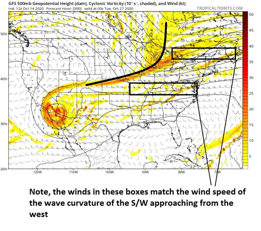
You can actually see that in the 'art' of weather graphics when peering over the 500 mb v- ...The positive vorticities swaths begin to curve or bow such that the southern ends lag back SW... That's absorption happening. Here's an example of the resulting positive sloping... random interval off the 12z GFS to illustrate the point:
-
No arg from me... I said just yesterday or the day before whenever that was that this might be a good year for NJ Model lows ... Miller B's fits in with those. We just gotta make sure the ambient flow doesn't end up with too may hypsometric lines ... because that is synonymous with huge wind as a base-state. That's bad for S/W's because their local wind maxes get absorbed -
-
can you run that regression for prior to, then post ... 1990... say .... or 2000, separately ? granted the sample set size is not inspiring much confidence in the latter interval - I still want to see the result. you've got all instances in there ...judging by the shear number in the scatter plot ( eye-ballin' ) that's like all ENSO deviation demarcation events going back ... I dunno but a long ways? I don't think the ENSO states are "as effectual" in modulating the winter patterns since 2000 as they were prior to that for a bevy of reasons that I've opined ad nauseam and don't wanna get into at the moment... But, it may also be that there's just not enough scatter plot ballast since 1990/2000 in to be of much use either - hands cuffed by prediction vs having to wait on verification in that sense I suspect the warm ENSO events have more memory than the other way around, particularly prior to 2000. But, because the other way around is more likely the base state in having "normal" unimpeded trade wind sea-surface stressing, that tends to keep the NINO 3.4, 1 and 2 regions less than EL NINO ... The base canvas would thus 'erase' the modest NINA events by virtue of merely absorbing its signature into the ongoing circulation of the hemisphere in those scenarios... NINOs however, might be more observably lingering ... just a hunch but also a digression -
-
Yeah...I'm seeing this as error prone in both direction - making it difficult to parse out a "correction vector" if you will ... heh seriously, ..the Euro somewhat more than less subtly at time, carries on with a tendency to carve the flow back W too steeply at Ds 5 .. particularly D7 + ... It then ends during Ds 8-9-10 with either too much end-state meridional structure, or... has to pass through one that was too much so ...correcting back flat by 10 - either variation, I see the Euro do that all the f'n time. Yet, as you guys joked last week ( and I agree frankly ..) you go to any verification scoring database and it's like all accolades and polish ... Maybe it is just something that it does over the box of 120 W - 70W by 40 N ...so inbetween the seams of it's testing domain ??? Just an idea - Anyway, what the Euro is doing is dropping the hammer - perhaps - too mightily in keeping with that tendency. So, we end up with a historic warm spell in the OV and NE regions. There's some flirtation out there with a BD but frankly ... even though BDs are a fact of New England life and we should expect them ( regardless... ), that deep layer general circulation set really does not support a very convincing one... Otherwise, that's a recipe for the latest hottest October temper ever between Dayton OH to Boston somewheres... It had this on a run ... yesterday - I think it was the 12z... So, it's been fiddling with this... But again, I need to really see this inside of D5 to bite because the Euro tends to have to go through said correction two-step - not always but we'll see. Thing is, ... you get to 79 on D6 in that with that warm front ..dry warm fropa too... But the atmosphere then starts caching kinetic charge ... and nights start elevating launch pads...such that by D3 of that stretch... you could be in the mid f'um 80s! ... relative to that animation it has... That's obviously a half bubble off the plumb line to go out and forecast that at this range, but, that's relative to this model run. The 2-meter depictions on that cycle definitely shirk the potential - it would be warmer D6.5 out to the end of that particular run. Meanwhile...the GFS ... it's bias is the other direction.. I mean, perhaps literally too - not just figuratively. It has a velocity surplus that is being missed by everyone, because the flow everywhere is also ... in a velocity surplus. Really incredible as a separate bamboozling phenomenon... but I'm onto the damn thing. SO, it ends up stretching the longitude of wave features so dramatically... it either ablates warm penetrations, or... gets so extreme beyond D6 that it flips into the next wave cog and the pattern rolls into the next configuration entirely... And that is almost like what is happening here when straight up comparing the D9 Euro to the GFS from 00z ... That synoptic variance would have almost a 25 F sensible difference/consequence for the NE on that run. We'll prolly end up somewhere in between ... which is banal and uninspired boring weather -
-
Halloween nor oh I think you mean the "perfect storm" - which I refuse to capitalize because of the cartoon provinciality in calling it that ... ? That was also Sandy ... btw - Not that anyone asked or needs the lessen ... but all these fit into that ilk, really. There are no true reduxes in nature; analogs are what they are but are never 100% Anytime the large scale circulation evacs a TC out of the deeper SW Atl Basin tropics/subtropics, pulling it up to where it is vulnerable to ... and exceptionally rarely succeeds, merging vorticity/physical fields into either a severing mid and upper level cold core low ..or trough capture in general, you are essentially dealing with similar ( to varying degrees) area of event spectrum... I've been posting about this the last couple days ... the autumn is the time of the year that this is likely to happen if at all, and amid the likeliness ... most of the time it is just in the models. For one, hurricanes need to be present as an initial concern -duh.. But, particularly the mid to latter autumn, when we start to see trough incursions probing deeper in latitude over eastern N/A, do we pass through a touchy modeling period of time. Every year we see this .. Usually - well, used to be ... the GGEM was the more guilty. Back 15 years ago, that model couldn't resist! Every cycle between ~ Oct 10 and Nov 21 seemed to wrapped up a D12 category 3 hurricane inside a rampart of baroclinic moating .. It was like the physics of that model had a duality at times. But, you know... it was just taking a real phenomenon that can happen in nature, and assuming it was happening far more frequently than it ever does ( in the virtual realm of its performance ). Out in the real world...return rate's prooobably like I don't 1::70 years for snow involvement? Just spit ballin' .. I don't think we very frequently see full on fusion deals - certainly not 1804's ...my god. ( so I guess in that sense, we are due? ... unless Sandy counts.. ) But, anyway.. if the perfect cartoon ( it's almost like the era was still a bit green/bush-league to the notion of fusion phenomenon so that perfect jazz had more cache ) is the storm you're thinking of the capture of hurricane Grace into a cut-off low S of the Maritimes was October 28-30th of 1991 - otherwise, I don't believe I recall a 1993 nor'easter other than that other rogue event that also got the notorious 'storm of the century' earlier that March.


