

Typhoon Tip
-
Posts
44,568 -
Joined
-
Last visited
Content Type
Profiles
Blogs
Forums
American Weather
Media Demo
Store
Gallery
Everything posted by Typhoon Tip
-
Wait ... there were three years bbb in the early 1950s? ...the suicide stretch my god But on point that makes me wonder about the ambient PWAT/WV accessibility in the GW models - interesting. But I don’t know if it accounts for all that because that seems like a disproportionately large response by that one metric when GE its self is decimaling its way up ... could be luck playing in... also - note the 1980’s ambrosia of couplets
-
Well ... I dunno it seems to me pulling back to back subpar snow seasons at 1000’ is in of its self perhaps harder to do than the SE coastal plain. In terms of implication - I can see 1998-‘99 as that was that super ENSO back whence they mattered -lol
-
well than bravo -
-
The stronger/ing HC might also sustain stronger easterly trade wind - supposition. That could "mimic" - for lack of better word - the La Nina state, however... So, we end up with stronger easterly trade... causing cooling... but that is still inside the HC ...and then the hemisphere above latitudes doesn't behavior very La Nina and again... heads getting scratched in early February when there's an El Nino California wind bomb going off lol ... just sayn'
-
That's a terrible look.... All the balancing is already stored in that usually deep vortex with huge saturated rampart of heights and violent wind so that's not doing anything - you want softer 'hypsometric' gradient, with steeper 'thickness gradient' underneath... It's complex -
-
Mmm I'm not sure to which conversation you refer to when/where I "refuted" - but fwiw, I have been very clear in hard text .. if not implicitly, that 'these are not absolute' ; it's about offsetting mitigators. ENSO is not 0 influencing ... duh.. The idea is as it should be, that it is not AS influencing when smothered inside an expanded HC - ...I even said, the 'art is how much so' at one point or the other. I just don't like the ready-reliance on ENSO as it doesn't fit with my personal perspective from education, a-priori as well as purely observational reasons. Off the record, in my own little fantasy world I'm actually put off by the ENSO failures as of the last decade to the point where I'm hostile and want to throw my hands and say it's all BS but out of respect for my fellow minds and that my indignation isn't so righteous ... I figure I could be wrong in absolution- haha Caveat emptor I suppose. But, warm(cool) ENSOs have not manifested the impacts they typically due around the Globe's known climate routes, ...over the last 10 to 15 years, as notably as they did prior to the coincident onset of the HC expansion - which to reiterate, is not me alone averring that circumstantial emergence. I have cited links and climate reports and papers oh my! I understand that these are large - in geological time concerns ... -- nearly instantaneous changes, but that unfortunately requires a proportional ability to be mutable and adapt if one is in the business of using "environmental signaling" to prognosticate. But I also admit there is a bit of smoldering commentary along the way that the Earth is in deep f'n trouble ... but it is what it is.
-
Here's an easy prediction: Trump’s out of this thing in 4.38 days from right now… a time in which he experiences nothing further of consequence … --> Rage against the Liberal conspiracy-Pandemia
-
I don't really have a problem with this in the DJF ... particularly the latter two months of that range. I think as the 'base-line' eddy gets established in the winter hemisphere, it will probably be at more times than not ...seemingly unrelentingly in compressed look that emerges by virtue of the polar winter heights reaching a nadir between Jan 15 and Feb 10 or so... In that time range, we may have seasonal heights over the area, but because the compression is there, the winds are hauling seriously ablading cold incursions and or limiting their impact on regions to briefer times ... There is a way out of this though... 2015 February - Firstly, those seasonal products by the Euro are not that good - just keeping that in mind. Secondly, should the N-stream just become so overwhelming, we could end up in one of the -20 C 850 at all time air masses...with powdering coastals faking huge seasonal snow totals.. If there is anywhere in N/A where that would likely to occur, it is in the eastern Lakes-OV-NE band, where the PNAP favors a persistently anchored trough. It does pull me to wonder at times if we can't sustain winter without that extreme - perhaps as an insidious "already" climate threshold cross that we're less collectively aware... The HC is being documented and observed, in the private sector and in scholar and scientific formal arenas alike - and given the root causality...climate change ... theoretically that does not lend one to think it is going anywhere, either. So that scaffolds the vision of the futre around that flow being consummately impeded from the S by heights that are not receding - and we're only talking about about 6 dm ... But that's all we need in the integral from 30 N to 70 N to trigger the velocity surplus...which by wave mechanics than starts jostling the R-wave orientations, as well, creates interesting indivudal temporal-spatial scaled event morphologies. Like 938 mb extratropical lows moving passed a region that thinks a Pratt&Whittney proving ground was exhausting through their region with a 6 hour 100 mph sideways show .... ( hyperbole but it was SOMEthing ludicrous!) ... weird shit. Anyway, non-sustaining cold before warm reloads to 45 N isn't a bad base-line in a ballooning HC... That all said, prior to the onset of that circumstance...these book end months ... mid Octo to Dec 1 and ...then again through April 15 ...perhaps May 1, etc... those times the compression eases and continent passes back through a tendency period for -EPOs .... It's sort of causing a recurrent 'split' in winter - It's not all the time and or absolute, either... Just "tendency" - so... Even though that seasonal product probably verifies well by dumb luck ...I could kind of see/tell/almost predict where that luck comes from.
-
Yeah ... separating the -AO from the +AO ... as being rooted in what cause is a whole 'nother popsicle headache - good luck! But I also like where you are going there, because a -AO base-line tussling with HC would quite reasonably cause a different "synergistic" hemisphere ...having those opposing aspects in tandem. I don't know how to visualize that resolution. The +AO is easy ... It's a contraction N of the westerlies/Polar Jet as we know... and that's sort of like giving the HC "carte blanche" - you know? So we wash in bathing progressivity and sheared out busted R-waves that can't situate ...and you know the drill... Anyone want to argue that's NOT what we've eaten the last half-ten ? If so, never log in again - But jokes aside, the HC isn't going anywhere - most likely... Most papers, sciences and scholars are leaning heavily toward it's anchoring in GW ... so - But... the +AO affliction is making the GW seem like whole numbers instead of decimals - which it still is. When they flash headlines designed to jolt awareness ( ahem...) that X month was the warmest ever ...they mean it was .01 warmer than the last 'oh-my-god-we're-all-gonna-die' month ... I mean it's not good that we are adding decimals ...no.. But, it's like Venus comes tomorrow. ...or even in 50 years... although ... things could be sensibly different by then if the "acceleration" shit continues ... Logarithmic change is a little harry out to 5 decades... Anyway, I'm not really sure about the +AO longevity ...it doens't fit the solar min curve...Last year was not right ... and it's persistence was also ... doubling down on that 'not righteousness' ha-ha. Seriously... I don't blame the QBO when the QBO was weak and there are plenty of -AO at similar QBO in the past... so, ... the MJO's were also biased on 3-6 phases, which is consistent with the +AO correlation - it worries me that the whole hemisphere was butt-fing winter ...from the Eq to the Pol and this is unrelenting... I am not sure that HC ... I don't see how - but it does seem to be a constructive interference that is making the HC very demonstrative ... making huge mid lat wind budgets -
-
Yeah I think this is the intellectual/ course of least regret in using the PDO metric frankly ... and by the way, check this but I think the multi-decadal curve is arguing -PDO/-AMO through 2030 .. So if it is positive - I have two thoughts on that... The first is, it may be a lie... Why? Because we are also now toting along this multi-decade warm basin signal. I think if you look at the last 200 some- months worth of anomalies products at NASA... 78% of the Basin has been in a positive anomaly 78% of the months or something ... ( making that up but it's been warm biased). *AND* that is now overlapping the -PDO according to the multi-decadal oscillatory curve that was constructed based upon reanalysis from 200 years ago .. that become more empirical mid century onwards.. Blah blah.. .point is - and I'm sorry if this chaps asses and/or rolls eyes but the fact of the matter is - global warming is f'ing this whole conversation up before we even have it.. Jesus Christ. But, suppose for a moment GW doesn't matter ( yeah right - ) ... the PDO/AMO move together, and both move with a very high correlation to the solar cycle. So it is an interesting diametric signal there... we have a multi-decade in situ warm anomaly - regardless of GW or not ...it's there - "fighting" the -PDO ...which by the way, should be a whopper given to the superposition theory and the deep solar min ... I keep coming back the same thing .. the primary force in the scaling of equations is the HC expansion and the polar field/Ferrel Cell interface velocity in the gradient saturation as overwhelming things. That's putting the previous modes that were better correlations more on the back burner - note, that is not saying they don't influence. Seems there is a tendency to read shit and think it's absolute stink and that's not the point here - but, we live on a dynamical world - and dynamics actually translates directly to "change" as per definition... Sometimes the turds of change just have to be seen or we risk drinking the cool-aide
-
The PDO - as I read back in the 1990s ... - is often prone to ephemeral looks because of sea-surface wind stressing. Which makes sense, considering the PDO's domain space is pretty much overridden by the wildest, windiest tropospheric realm on the planet, ... pushing water plumes around and upwelling this and loading warm into shallows that. It's like one of those thumb-slide puzzles. Such that given to how deep the surface layering is (warm)(cool), either can be disintegrated instra seasonal and if significant enough, on scales of mere weeks at that. That lends to me questioning the usefulness of assessing the PDO in any given July through early October time frame, if one is to assess how it may look/be somehow correlative in ensuing winter. I wonder if anyone has ever took the scalar PDO of August and compared it January's ? Like -1 August = ? January in the "tendencies" - I bet the correlation is more noisy than we think... while biases the decadal signal... Such that if we are in the positive(negative) modes ... Jan tends to reflect the decadal signal, and August's throw out the variability. Thing is... momentum left over from spring may be mashed up with solar modulated summers, at a time of the year when/where said stressing is not as mechanical adding to the deception ... and that can falsely reduce(elevate) negative(positive) PDO's which ... btw, the "D" in P - D - O stands for "Decadal" for a reason... It doesn't mean "Dailies" ... such that a Aleutian bomb may neg the shit out of the domain up there ...but not really consistent with the longer term's vastly more correlatable decadal lags. Such that there's a couple faux negatives in Sept... a bomb in mid October that upwells, and everyone forecast a winter -PDO correlation that doesn't mean anything because the circuitry is all positive by Thanks Giving and stays that way until March. Just attempting to some healthy skepticism here -
-
speed/shearing is already observable ... Look at this flat baroclinic wave induced leaf on satellite - f'n haulin' absolute ass ...
-
Ha ... I wonder how much that is being pulled/weighted by the last 10 of that 30 years... Basically, wouldn't mind seeing that in 5 year intervals to gather an idea on trend.
-
You know... perhaps that is related to why the Atlantic Hurricane season ( thus far...but inevitably will end this way ...) suffered odd-ball MDR truncation of TC genesis due to easterly shear anomalies... In that sense ...and strengthened HC is driving unusually strong easterly trades due to it's growing mechanical influence on the global eddy - ... in other words, an SST modulation and sea-surface stress factor causing that...and may be mimicking a La Nina more so than a real La Nina. Maybe this is all backing us into a nice hypothesis for what the ENSO variance - it's always just been a kind of oscillatory HC ebb and tide in that particular atmospheric mode. When it is storng... easterlies tend to increase and that moves warm air west across the basin... and vice versa - ... heh.
-
Hopefully no one ever did that - ...no, I've averred often in the past and over years that there are no 1::1 correlations in these teleconnectors: Earth, Air or Sea... certainly not in how they interact and cause synergistic outcomes. Having said that, that's not so one can go, "phew, I can still be ENSO reliant" - it would be unwise to weight the 300 year span of ENSO vs the climate impact model of the present era and going forward. How much so? That's your art - not mine. There were papers written about the recent warm ENSO events failing to materialize along expected climate impact routes... (they're out there in edu repositories - ) This isn't just my theoretical ranting - I am trying to bring this to general audience attention and have been supplying links - but... you know how that goes ..old habits - anytime there are abruptly dissenting points of views, the tribe knee-jerks in incredulity if not vitriolic stake-burning. Lol.. But, this is more like the internet causing bubble interpretations that are self-re-enforcing, where the agencies that own the information closer to the reality ...are often left on a metaphoric island while the party boat of faux ideology and those that act upon those doctrines ...sails away toward an enabling horizon where Trump demagoguery is somehow construed as a proactive vision for Humanity.... Just kidding - No, but ...as usual, the reality is a matter of fluid scales and degrees of mitigation - that's how this works. The ENSOs are "being" muted - they are not "muted" Sometimes it is seemingly absolute ( though would not be...); sometimes the limitation being observed appears to not be in play at all ( but it still is...). Everything is being subsumed or supplanted to some amount ...but above and below thresholds of observability. It's this simple: If the HC expands too far beyond the ENSO warm(cool) band, that weakens the ENSO as a "direct" trigger ... It probably becomes more "indirect" in that sense... the triggering gradient zone shifts polarward and the ENSO is part of the HC integration ... But, that offers all kinds of f-up crazy shit like sped up flow ( ding ding ding ...!) and arc PAC jets that tumble over and create unusually high frequency of -EPO ridge pulsations... enhancing cold loading at transition seasons... all this stuff can be mechanically rooted. The thing is... the heart of winter the polar hemisphere bottoms out seasonally and then the gradient and wind saturation becomes dominant as an impetus and ... well - My assertion of the NINA ...was kind of snarky for one. But not having much forcing is based upon a simple notion of arithmetic thinking - if the NINA is less than major, ...or, less than moderate, and in keeping with the above essence ...it should be more lost in the muting effect of the HC's having engulfed it so much so that it can't "trigger" through a direct gradient response ( which IS the circuitry) . I don't have any ego horses in this race and don't give a shit if I am wrong - but...I think this stuff offers a nice ( at least) entry explanation as why NCEP, NASA and Farm Joe's seasonal outlooks since 2000 have all been increasingly stinking pieces of shit... No one has forecasted ground-based airline velocity records and jet speeds so ludicrous as to wonder if the planetary rotation rate night even be getting effected by atmospheric torsional feedbacks! (Sarcasm) ... But what has become routine over the last 10 years... Yet, every autumn the same seasonal logic is gearing expectations .. okay.
-
I don’t think La Niña is forcing much. patterns may look coincidently like it from time to tine as the ‘unmanned firehouse’ happens to meander ephemerally thru the climate signal but tall N Pac arced jet’s likely to fold over either way from other emerging factors unrelated. The -neg EPOs intervals while ENSO forcing is subsumed and supplanted
-
That looks like the expanded HC compression base line frankly
-
OH yeah...wasn't that the year that it was like 50 to 70 F every afternoon until mid January ...when finally, the AO tanked on our side of the hemisphere the script flipped... I thought Valentine Storm was 2007 though and we finished stronger - but it may be eclipsed by the specter of the cosmic dildo flogging that occurred in the first half. I don't know.
-
Tends to happen ( lol ) when transporting -20 C 850 mb air plume over a still swimmable synoptic-scaled lake
-
Yeah that too - wasn't even thinking of bowling balls - but ... Case in point - does anyone remember that weird early October thunder snow squall event that hit Buffalo like way back there... autumn of 2006 I don't believe the ensuing winter (Will ? ) was particularly good or bad ... I mean that was clearly a rogue event/fluke like Scott just intimated... and was indicative of nothing.
-
Here's a thought - ... folding hemisphere/synoptics means early (late) cold shots... exciting snow chances at those times of the year - both anomalous for the last 200 years of date ( but perhaps not so for this present/immediate climate era ), but... since the mid winters are getting disrupted by speed saturation and R-wave progressive flows related to that ... it may be systemic to think of snow in October as increasingly likely ... while "organized" stormy and cold stable pattern deliveries as less likely in winters - period. And that those two circumstances are related because of fast atmosphere overall - but that does not mean they are connected by some other physical timing ... We used to debate pattern timing up at UML in Synoptic/FAST ...and we used to grudgingly agree that snow in October might be a poor correlator to mid winter, because of the normal gestation of pattern residence. There's really like three bell-curves there... a 10 day ... 45 day ... 90 day.... Patterns tend to 'click into temporal' cogs like that, before modulating to something new... Now, it can be muddled some by 10 days of pattern that flips... only to flip back ... so, which was it... Relaxations are part of pattern persistence however... and often the pattern's true residence has to be analyzed passe to determine that stuff... Anyway, 1995 was two 45 day long patterns ...interceded by a 10 day relaxation... ( example ) ... That's sort of what we played around with. Snow in October doesn't fit winter in any numerology of the bell-curve of pattern gestation/timing ... 10 days equates to a Rosby roll-out in early November... 45 ... terminates just prior to X mass ...usually in time for a grundle bomb too as though stalking that particular homage ... the 90 day might work, BUT, ...because October is the transition month...seldom can a stable R-wave distribution really be maintained through that inharmonious wave time of the year...making 90 days ( 45 for that matter..) less likely to occur beginning in that month. In effect, October is kind of in no-man's land. But, again...that is based on the traditional data set ...which I think is in the process of being significantly changed due to the last 15 or so year's of behavior and probably going forward in this climate change shit.
-
All the while negating the morality of deception douchery alone the way -
-
I wonder if those correlation arguments or points are reducing in value anyway... If this speed stuff and the folding of the atmosphere at large scale, causing book-end winter expressive patterns that yield to internal seasonal gradient saturated craziness has merit... Those correlations are based on a heredity that may no longer be valid. So, while they may not be entirely moot, their usefulness questionable.
-
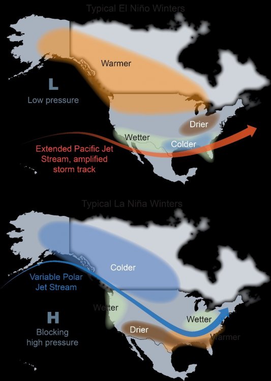
Bingo! Yeah they're a gov org - they can't make supposition? Not without huge problems - lol... So, yup ... I don't mind the 'leading prose' ( if you will ) so much, if at least it can be vetted through a modicum of analytics... which this does! Both apriori but education combined. Anyway, for the general readers, I love their ( apparently negative rendering when copy and pasting) image acuity and simplicity as reference ... Keeping in mind, I think these base-line states are being disrupted by the expansion and velocity stuff as we are describing... So, perturbing and adulterating these looks ... yup. how? million dollar question. I strongly suggest that the straight up ENSO statistical correlations are in trouble... We've had modes on either side of warm(cool) in the last 12 years with apparently limited impacts around global notorious climate zones .. but here is the base... Know what is funny about this... It's odd to me that our best snow winter comes at like +.2 NINO regimes ? when this image smacks as though -1 would be the big nuts... Interesting -
-
That is the SST correlation with the wind pattern stuff.. https://science2017.globalchange.gov/ ... corroborates as well, and discusses the atmospheric modal changes that have occurred in the past 30 years as part of this total response in the global hemisphere - Hadley Cell is an atmospheric eddy that girdles the tropics and subtropics around the planet...featuring ( in the means...) rising air near the Equatorial Monsoonal Trough zones and augmented by MJO ... etc..., polarward mass flux from convection deposition in the high troposphere, and downward ambient flow tendencies in the midst of subtropical ridges ... On the polar side of these ridges, the flow terminates to the westerlies band, the demarcates the interface between the Hadley Cell and the Ferrel Cell, which is the polar cell that orients at higher latitudes ( lower if talking about the southern H. ). The HC expansion is noted in the atmosphere - Refer to chapter 5: 5.2.1 Width of the Tropics and Global Circulation Not to laboriously reiterate but...the expansion of the HC is butting up against the lower Ferral Cell where cold hypsometric layout and compression resulting, is causing enhancing wind velocities as the balanced geostrophic response. In fairness, the article/content may not describe this latter wind response outright - and I have been clear this is my own hypothesis, but it is a damn good one! Regardless of refutation as to cause, the previous "stable" climate R-wave climatology is in peril during colder seasons, because wind speed in the wave mechanics is physically instructive regardless and we have had velocity and gradient saturation ...regardless of ENSO and other factors - it's become a base-state. ... Couple of plausible examples of altered R-wave climate: NAO blocking rarefied because blocking constructs are inherently more difficult to maintain in excessive X coordinate wind. Also, tending to fold the top latitude flow over mid latitudes, earlier in Autumn exaggerating early cold loading into Canada, as well as upon exit in springs. So, if we negate this shit in our seasonal outlooks and/or even modeling -based weekly forecast visions... good luck .


