

Typhoon Tip
-
Posts
44,568 -
Joined
-
Last visited
Content Type
Profiles
Blogs
Forums
American Weather
Media Demo
Store
Gallery
Everything posted by Typhoon Tip
-
Anyway, jokes and speculation aside... Though I have my convictions emerging about that other shit ...I think in the meantime we have a N-stream dominate winter by appearance. Here's the trouble though - I don't know if STJ's are also problematic in an expanded HC thing ? Because ... seems with the gradient being pushed/relocated N of 1700 - 1980 ... more so since 2000 ... that starts exceeding those latitude where we see that particular feature - the impetus behind this reasoning is that for one ...I am some kind of catastrophic loser with no life ... why am I f'n typing this crap ... but two, gradient in the troposphere derives the axis of westerlies/Jet streams by classical convention -
-
Sure - if one assumes the modoki this and the NINO 1+2 that are still AS effectual in forcing ... maybe - sure... I'm not here to make declaratives and aver these hypotheses need preclude the scientific process or nothin' lol - I'm just saying, Modoki shmokey ... personally? I hunch ENSO over all, thus certainly idiosyncrasies contained within, are being rendered less forcible to the entirety of the planetary integral. Oh,... I bet this is the insight of the young Met century that chaos will now go out of its way to happenstance/circumstantially make it only look less true by metaphysically constructing a dildo... I mean a winter that actually fits the predisposition. Everyone goes seeee ... lowers their guard, and the oceans stop C02 fixing and the extinction event is complete - muah ahahaha oh, sorry - wrong subject
-
Mmm ...yeah, wasn't gonna chime in on that but ... that seems to me to be a simple matter of 'momentum storage' ... Other intermediary obtruding forces can mask or mute (transiently) those forces that have a longer integrate curve/weight. It's like ENSO ( prior to 2000 I should add ) was like a revolving door, and summer temporarily holds the door against the motor, but soon as the kid stops f'n around and playing with the door, it resumes it rotation - This is a useful intellectual exercise - it sort of adds support to what I was just talking about - pretty much exactly, too - What does summer do to the hemisphere? It neutralizes gradients ( in general...) the ambient gradients are lessened...the flow unwinds and becomes more nebular because the velocities are less ( A is not longer motile toward B ) ... and that hides the ENSO by cutting it's integral forcing - It's almost a circumstantial proof right there ... if we extend the HC beyond the kiss-point of the ENSO with the westerlies,... that's sort of cutting it's integral forcing ability. Same thing in principle.
-
Maybe it is because the ENSO SST distribution is no longer AS usurping as it used to be in the total integrated machinery of the planetary circulation result. As an extension ... and possible connection to GW, coincidences suck in physics... usually, there's causality connection; and it appears more so than merely coincidence that recent ENSO events, having not been registering as impactful along/at normal climate pathways as they were prior to the recent empirically proven GW acceleration ..., is just such an annoying coincidence ...which by the way, the advent of those failures has been concurrent with recency - My hypothesis is that the expansion of the tropical/subtropics found here : https://science2017.globalchange.gov/chapter/5/ ... is at least partial in that causality connection. The longer version: The idea of that expansion of the HC isn't my personal work - so ...maybe start considering that ( not you personally but in general - ). But, changing the previous ocean-atmospheric modal exchange is as good as any initial educated/existentially rooted guess. It's just to gin up a scientific discussion if not actually process therein, to formulating theory as any I've heard... Which, unfortunately ...isn't a lot - and I admit to that frustrating me. These are non-arbitrary substantive observations being made by a much larger bevy of sources other than that just being made by me ... A ... flows toward B. There's a gap between just being statistically/numerically reliant, and understanding that gradient is everything in Universe. If there is no movement of A --> B ...entropy is infinite and there is nothing? This isn't mere philosophy. All actions and our ability to sense " reality" itself, are because of cause and effects an essentially infinite solution of forces attempting to get to a rest state... That includes both why the wind blows, and... one's ability to sense the wind blowing. This adolescent truism seems to escape us when it comes to the teleconnectors and the statistics; when we assume +1 NAO means this in the atmosphere for us, that sort of unwittingly acts as though that +1 is a force in itself. It's not. It's a result over time then averaged. But the nature of A is no longer stable. And that changes how A moves toward B ... That change = seasonal forecast pieces of shit for not seeing it. SO... tfwiw - ... If the HC band expands above the previous interface of the ENSO ocean-atmospheric coupled region, that is a whopper change in how A relates to B ( which in the context, 'B' refers to the domain outside the ENSO o/a realm) .. It's like ( haha ) a stable marriage. It's runnin' along fine, but then B becomes an alcoholic ... an abusive one at that... Meanwhile A is still doing what A always did ( in this metaphor, oscillating between warm(cool) phases of ENSO), but the changes in B ... means the nature of the marriage has changed - what we do when we ignore expanding HCs and GW and all this shit ...is we assume that B can be an abusive asshole alcoholic and it won't change the nature of their relationship. WRONG I admit to having noticed gradient saturation and higher velocities/R-wave stretching and progressive patterning bias over the last 15 to 20 years as becoming more discerned over the course ... but, this science publication above shows that said reality outside of said frame, is ALSO onto this - and you should be too This regressive reliance is not showing evolution or learning ... I realize that's hard to do in a pathology that is hardened across generations of other consistencies...but therein is the problem. We've lost the consistency - I don't intend this to be an admonishment ... people really need to start questioning the % forcing capacitance of the ENSO's longer duration oceanic-atmospheric coupled teleconnector when gradient changes how it integrates.
-
It's an interesting turn of phrase 'recency bias' I know you don't mean anything by it ...but 'bias' tends to imply an attitude against something, particularly in the parlance of an internet "water cooler" social media diversion - haha... but yeah ... I like to rely upon trend quite a bit. Trend awareness is equally fair as a word choice, and is actually a wise factor in any deterministic aspect of weather forecast - range and domain notwithstanding. Particularly, when a given trend can be rooted ...or at in the least suspected as being, causally linked to x-y-z ..etc. In this case? I think there are reasons - valid - to assess the trend of recent winters may repeat? And I mean to put the "?" on that.
-
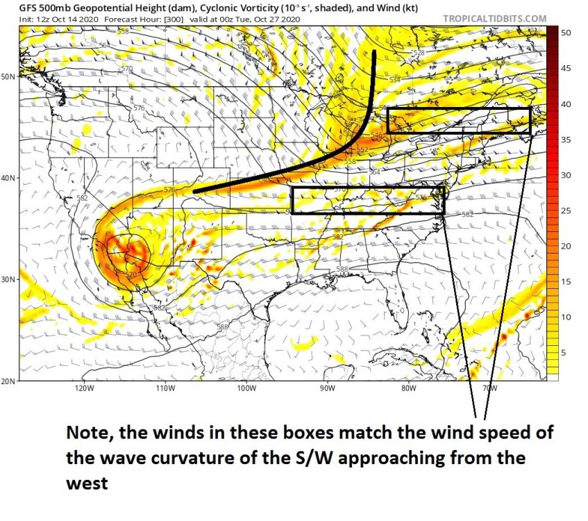
You can actually see that in the 'art' of weather graphics when peering over the 500 mb v- ...The positive vorticities swaths begin to curve or bow such that the southern ends lag back SW... That's absorption happening. Here's an example of the resulting positive sloping... random interval off the 12z GFS to illustrate the point:
-
No arg from me... I said just yesterday or the day before whenever that was that this might be a good year for NJ Model lows ... Miller B's fits in with those. We just gotta make sure the ambient flow doesn't end up with too may hypsometric lines ... because that is synonymous with huge wind as a base-state. That's bad for S/W's because their local wind maxes get absorbed -
-
can you run that regression for prior to, then post ... 1990... say .... or 2000, separately ? granted the sample set size is not inspiring much confidence in the latter interval - I still want to see the result. you've got all instances in there ...judging by the shear number in the scatter plot ( eye-ballin' ) that's like all ENSO deviation demarcation events going back ... I dunno but a long ways? I don't think the ENSO states are "as effectual" in modulating the winter patterns since 2000 as they were prior to that for a bevy of reasons that I've opined ad nauseam and don't wanna get into at the moment... But, it may also be that there's just not enough scatter plot ballast since 1990/2000 in to be of much use either - hands cuffed by prediction vs having to wait on verification in that sense I suspect the warm ENSO events have more memory than the other way around, particularly prior to 2000. But, because the other way around is more likely the base state in having "normal" unimpeded trade wind sea-surface stressing, that tends to keep the NINO 3.4, 1 and 2 regions less than EL NINO ... The base canvas would thus 'erase' the modest NINA events by virtue of merely absorbing its signature into the ongoing circulation of the hemisphere in those scenarios... NINOs however, might be more observably lingering ... just a hunch but also a digression -
-
Yeah in his defense... some sort of training warm frontal wedge convection appears to be going on in his vicinity https://www.cnn.com/2020/10/13/world/un-natural-disasters-climate-intl-hnk/index.html
-
it's too much - sure... Glad you picked up on the sarcasm - tough to deliver that ... I do think the world is warming and I do fear thresholds and so forth but come on - look how the models took the planet of Venus and crash-landed it into the Pacific Basin ...it's like minus 10 SD La Nina which is outside the theoretical bounds of Terrain physics or something ahahaha
-
...Since you asked me and care so very deeply how my opinion affects you and all ... I think this could be an N-stream dominated winter, but one that wends its way to (climate signal + average cold)/2 = ... take a f'in guess how that parlays snow... it's like a N-stream dominate winter superimposed over a planetary hockey-stick (denying ...) climate modality that doesn't end well for winter enthusiasts ... oh, not for decades. Okay, as we know in climate science, it doesn't move on a predictable slope though. I'm starting to wonder if might cross over a threshold ... years before Will's take on things that a 'no winter scenario' here won't set into until beyond the visible universe of our life spans -- how? because we arrogantly ( as human tendency ) keep expecting a slower deal merely because our egos get in the way of the fact that just because we can't imagine horror unfolding tomorrow, that means it can't happen. But, threshold happen by breaking at stress points... and boom! as they say in Ebonics, 'we be f'ed' Not to be alarming or nothin' but Mad Max's setting was the year 2021 muah hahahaha. The U.N. isn't holding back today ... 'the earth will become an uninhabitable hell to millions' .. Somewhere between those two futures lurks the inevitability smearing of our Currier&Ives portrait of winters - ...maybe
-
The obvious ? that's a global warming depiction there ...when every single guidance source has an unbalanced warm/cool ratio ... that's a warming world - sorry.
-
My lawn actually greened up about three or four weeks ago when that last convection ( prior to this recent macroburst event ) came through... We were actually straw lawn beige ...then, we got an inch.5 in a two thunderstorms on the same day... and within 3 days there were new green blades coming up and since... it's green. It's never been really very reflective of a significant deficit here in the Nashoba Valley, but.. in fairness, I have had a convective season here. I was under something like 8 t-storm warnings and 2 tor-warnings ... No tors verified but we had big wind and lightning cut up rains on at least half those t-storm warnings. Granted, convection tends to bonanza locales while boning regions... agreed, so this area was probably lucky in that regard. The small stream just down the road that is very seasonal rain readily responsive was actually dry enough to walk without wetting foot other years when the region was only yellow in patches by the Monitoring folks. This year, it's still managed small amounts throughout -
-
November 2019'S NAO averaged negative by a click and a half SD ... and then in the first week of Dec, as the index began modulating positive toward a December destined to a modest +.25 to .5 SD, ...it was right in there most of us acquired pretty much 70 or 80 % of our yearly snow ballast. We seemed to double that in morning frosts through late March from that point forward. The rub on that was that said event was not 121" of snow - lol But, the early and deep polar index ( NAO ) last year was off-set by the AO by a whole month. Interestingly...according to CPC ( https://www.cpc.ncep.noaa.gov/products/precip/CWlink/daily_ao_index/monthly.ao.index.b50.current.ascii.table ) the AO carved out a deep January, when the NAO was positive. That's interesting... Because those two domains share/over-lap a consider amount of their geographical area, so having the AO manage a -1.5 SD while NAO was positive in change, ... that's really stressing the odds there... The CDC's correlation table has the AO and NAO positively correlated by some .7 ...which for atmospheric phenomenon is quite indicative. Yet, they found a mid winter butt bang status like (-1.5 SD AO)( +.5 NAO) ? Just sort of cynically ... I'm inclined to think our misgivings about 2019-2020's winter as an entertainment gestalt might be related to that rareness... EDIT this is wrong - I miss aligned the columns - sorry ugh. They were better matched afterall ... = December 2019 was doomed after that first week, but the month salvaged by virtue of actually having the first week's snow/storminess take place. So what I am getting at is an aside point along the way of this discussion; since the year 2000 ( as a notably observable trend) with either snow, or...patterns conducive to snow ( that latter may actually open up the totals to a bigger number but is subjectively debatable popsicle headaches stuff ) has been been recurrent themes in autumns. I see it unfolding in the GEFs/ tele's ...and the operational GFS ... yet again. The last cycle of GFS has 516 DM thickness across the NP on October 18!!! That's just not normal...sorry... But, it may not happen? But the fact that the model keeps doing it...and, we have in fact almost all but grown accustomed to if not expecting our snow in October ( ludicrous by any imaginative standard prior to the year 2000) ...I think it's all connected. And it matters... because... the NAO blocking of November last year went on to NOT do shit for winter... It was not correlated to winter at all at least in that one shimmering example. Yet, the AO...which was positive in October and Nov aggregates, went demonstratively opposite. It's not just noisy...it's a damn din and polar indexes in autumn were excessively negatively correlated in the one example last year. My most recent thought on this winter is a n-streamer ...
-
Purely anecdotal ( ...though my convictions are "observationally" rooted - lol ..) but I don't see a useful correlation to the actual weather patterns is the thing... Now ... obviously 'blocking' is a distinction of patternization ... But, when time is introduced, nah. Not by frequency for either restoration and/or modulation tendencies when comparing Octobers to their ensuing DJF of any given year. It's noise in other words... 30 days of noise in October "might" contain orientations that equal or bear some resemblance to fractals embedded in the noise of 90s days. What happens to November in that - I mean... it's like ( to me ) arbitrary when we start doing that... may as well compare April 13th's 6 years later to October 12th's ... aha! Pointing out a rather obvious circumstantial concept: 30 days is long enough that a blip for a week, or even two weeks of October blocking(no blocking) may occur; but then 90 days is an even longer...thus, much more likely chance that either of those circumstances may be ephemerally observed - think about it this way ... a progressive pattern tendency may go through a 'relaxation' - well, that relaxation by virtue of needing to go the other way to actually achieve relaxation may mean 5 days of transient -EPO(-AO)-NAO in there...or even two week's worth of it...before the the next 40 days of progressive winter ruining piece of shitness sets in... What? do we say that was a correlation because say, there was a typhoon over the western Pacific back on October 10 early that autumn that happened to recurve ...building a height response over the Aleutian Basin --> brief NW flow downstream over western Canada ? It's too much of a stretch to suggest those disparate moving parts have any kind of direct or even indirect causal connection ... So in simple terms ... yeah - "weak" puts it maybe even too strongly if you ask me. I think this is a simple matter of 'conditioning' ... Circumstantially, if there is a 100+ winter snow year, the antecedent autumn sticks out in memory ... because as part of the human condition, we seek and create patterns to describe everything we see in nature. It's why we discovered ( or invented - jury's still out on that..) mathematical rules, and language to convey the mechanics. Add artistic expression to that... it's all creating patterns from the nebularity of reality... blah blah ...that's an infinitely deep well of philosophy ... But, on point, a big snow year happens rare enough, that the Octobers that preceded it offer an easy guess-vector. But unfortunately, the age -old statistical argument of that not being a substantial enough data density to offer a high confidence ... screams at us. Top 20 years of snow and cold and ... winter cinema in general... is 20 Octobers - wooooh! 20 Octobers out that last 300 million years since the break up of Pangea sent Europe and Africa sailing away to the east and created the distinction of eastern N/A... It doesn't automatically preclude the possible correlation useful, ... that is true. But the convention of using statistics, which "correlating" is ... And that requires that the entire course of discussion does not require anyone reading as much as I have typed over it just now... haha. But, they say there is a modest 'negative' ... okay - maybe that is just because there are only a handful of years where the signal was just planetary scale, thus large and immovable and lapsed longer than typical pattern gestation...into the ensuing DJF. .. I would almost suggest that aggregating Oct and Nov might have more statistical correlative just based on these weighting concepts -
-
Strongest easterly jet phenomenon in the lower to mid troposphere along and S of the 30th parallel ..due to the strongest HC in observational Meteorological history ... augmenting the NINA state. ...mm possible. I do get the feeling ..at least wonder, if the the "global La Nina" story is not as emphatic as the SST due to exaggerated low level easterly stressing giving the latter a PR goose. It may not be a La Nina in the integral nearly as strongly as those SST anomalies ...meaning considering the total hemispheric interstitial factors that in whole, drives the ENSO states along... Simply put, maybe it's a weak to moderate integrated La Nina on whole, but with a low level trade wind exaggerated SST distribution contained within ... Never be able to separate those two - or at least 'good luck.' Chicken vs egg headache too - I think we're having a northern stream dominated winter ... and that is super-imposing over the extended HC latitude, where the layover is a positive feedback. We we may at times even observe the 'faux' STJ from ...or just a split into Canada/west...when the PNA tries to lapse .. But in those scenarios we're merely splitting the N -stream; southern component ends up with an mixed/ ice storm deal as the main storm profile threat when it does. And, ...lots of height lines and winds as a canvased look. This may be a good year for NJ model lows ... '86 Novie types...
-
Oh sure - wasn't intending to mean we can't use climate ... my skepticism triggers at low observation of change I suppose. Just to reiterate for anyone following ... it's a matter of how fast the climate is changing in assessing how obsolete the past has become - We are right ...we are to date talking about 1 degree this and a lot of decimal modulations. That doesn't seem like much? By convention of numerology ( lol ) ... the # 1 is a small digit. But I would caution, therein is risk ...small numbers don't mean small changes to a system - particularly if said system deals with the machinery of a planetary systemic scale, and the endless polynomial terms influencing the synergistic outcome. It may in fact take ginormous change in a system guided by both positively and negatively compensating forces, to actually register a single degree of change in that system - but the boundary of change is being stretched ...will it snap? And, that ginormous change then is like having held back a historic flood with an outmoded dam. The climate is said to be 'changing' faster than the early climate change science predicted it would. Threshold mechanics comes into play as well.. I mean, we may be pushing decimals, then boom ...flash 10 pts .... you don't know. I don't know. We are in unprecedented waters in terms of Human influence in the geophysical environment of the planet. That much is empirical and cannot be argued - the anthropogenic C02 contribution, when added to the normal geological processes, sum to the biggest flux ever - unless that conclusion's been veraciously shown to not be true. Can we imagine ( then ) if we add Siberian permafrost locked Methane to the party - ho man. For all we know, there is lag in response and as the momentum for change itself gets going, we haven't seen thus felt the punch of it yet ... Even using sophistication of ice-coring and trapped-gas chemistry this, and isotope that ... those efforts are reanalyzing past climate change events that were not triggered by that which has ever happened before - to me that gets dubious quickly. So in that same vein/philosophy .. we're trying to use seasonal snow behavior from .proverbial .. 1948 datasets ? heh I may also have a personal bias in the cause-and-effect-relationship observation. In the last 30 years, we are hockey-sticking climate change, ...decimals or not. And in that time, we are seeing suddenly some 60 to 70% of Octobers with at least a chance for synoptic snow and a cornucopia of global outrage for enter alarming observation here [ ]. I think we can use climate of course...but I have that caveat emptor and asterisk sort of in play when I do -
-
Yeah...and honestly, the easterly Trade flux anomaly is just something I've recently flashed into the old sci-fi library of personal guess-work hahaha... But what triggered me to speculate on that is observing the behavior out over the Atlantic hurricane season...and the propensity of easterly shear. I used to think of shear as a west problem rearing up in Meteorology. When the wind turned around E at mid levels, look out! Suppose to be a good thing... but his year? It was f'n fire hose man.. mitigation of TW's moving W,, everywhere S of the 30th parallel. I saw TD after TD fail to sustain chimneys because they leaned and torn off with anvils making the Leewards when they were only half way the distance across the Basin... That much is not guesswork, it was actually seen.. Then noticing the west Pacific has been dearthy ( so far) too...particularly the western area of the Pac Basin. Both the Atlantic and the Pacific open areas are more prone to whole-scale balancing of mass load ..whereas closer to the Americas .. obviously the circulation structure changes at large scales might disrupt those 'orderly' field layouts and so we've seen some better growth profiles at home. Interesting stuff... but, what is interesting... the season was forecast' to be above normal in activity and they nailed that!!! The chagrin is that the 70% of it was rotating cumulus clouds oh my god - run for your lives! But the shear seems to be the suspect for the low ISE ... and just from my own records it was easterly.
-
Factoring in the hyperbolic jest might slow the train down enough for you to hop on board. LOL ... Yeah, no I don't know - Will or someone would.. I think Logan 110" ...? which is probably 200% ..spit ballin' ..I don't really have that area of Meteorology on my mental sleeve. haha
-
Right ...so we're actually still owing - lol... Nah.. in actuality, since the climate is changing and that is showing up with increased PWAT and totaling everywhere in the world with huge growing sample set of data points over 30 years now ( so don't give me that shit... no you the general reader ), ... the instability in the climate sort of makes any kind of statistical argument for "balancing" bullshit. Balancing what then - ? For all we know...we are heading into a 300" per year winter tendency and that was the first one... you get 4 off.... now we'll get two in a row...then we'll get 3 off... and then 3 in row... then we'll get 10 in row, and then they are all rain 2060 ... Or something else altogether. Point is, climate changing means ... you can't use past climate - ...it's a matter of how fast the change is occurring to determine how obsolete the data really is...
-
Mmm I wonder ... See, - gosh ur gonna hate this - I think the HC expansion shit is playing a role there. The flow all summer was not relaxing as it typically did ... between 300 years ago, and the year 2002 ( ~ ) for typology/summer eddy climate. We kept up with jet surpluses through the summer ... oh, we were no longer getting 180 kt sustained westerlies at 500 mb between SFO and London...no - but, we were observing anomalous gradient and faster flows by some subtle measures, enough so to sustain Rosby looks too ...The nebularity of summer was showing less entropy ..or 'breakdown' of the R-wave structures than normal So wtf is the point? Well, my point is, something is driving the gradient in the westerlies...and that is where the HC terminates in free-space with the lower Ferrel Cell above the mid latitudes. So, it is likely by logic alone that the HC is still strong ... By convention of that, the easterlies trades underneath the westerlies and the HC are getting augmented by large scale mass-conservation argument alone - perhaps ... This part I admit to more speculation, but from a geophysical meets with "conceptual arithmetic" perspective, it's not a bad notion to wonder if enhancing trade flux is causing sea-surface distribution - and that what we are really seeing is that more so than a systemic La Nina. It matters ... because, that means the gradient distribution in the total hemispheric integral is not likely to trigger the La Nina climatology as readily - at some point... scientific speculation has to considered. I'm not averring fact here lol... but you know what I mean. I'm just saying that it is possible a stronger HC is playing/accentuating matters ...and while not a "faux" La Nina...it may be exaggerating any real footprint there. So we may be looking for -1.5 -related climate impacts and wondering where they are again.
-
I remember musing the numerology of 2015, SNE's ... 300% above normal snow that season ... and getting no even acknowledgement - gee wonder why lol.. ... if it snowed 0% for three consecutive years, we would be perfectly average. Now, since it has snowed substantially more that 0% since that 300% season, .. purely from a 'just deserts' perspective, we probably have to go another 13 years of 50% ( smeared out in between warm ups in sloped sun over dead Earth) where the 50% is only there because of snow squalls at 2 am .... to finally get to our 20 years average and all is good and every has been delivered just they way the wanted it... muah hahaha By the time the numbers work out ... the cadre of conspiracy to correct the population down to a select few will have perfected upon their failed SAR-CoV-2 weaponization ... So in effect, 2015 was the last winter - and we didn't even know it while it was happening.
-
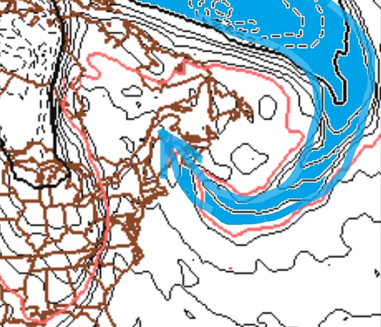
Not that you or anyone else in particular is doing the following ... this doesn't save winter, either - ... I sense a tendency to rely on stuff as a denial enabler LOL Seriously these offsets are more like "somewhat reliable" ? A warm H5 anomaly .. will tend to promote a warm 2-meter result in the longer term when circuitously getting through all geophysical processes that connect those two metrics. It's just that for us here in New England, we tend to "tuck" and curl the flow at all scales, both synoptically and beta-meso scales. At the continental scale ...the whole of the westerlies flow coming off the Pacific tends to rise in latitude due to the oceanic laminar flow encroaching/sensing the inhibition downstream of the western topography of the continent. As the air 'piles up' the Coriolis force then curl it into a anticyclonic orientation.. which is why the rest state PNAP is always a modest ridge in the west..with a flattening out/subtle trough impression working east from the Rockies ... Since the natural R-wave/long-wave distribution of the planet also nodes a trough in the Maritimes of SE/E Canada, that means that confluence over southern and southeastern areas of Canada tends to occur given time and space... So, that's tucking the atmosphere back SW as a - for lack of better words - "potential vector" always in place. Here is an idealized example from a recent Euro run ...showing this this tucking behavior ... at synoptic scales: In this case...the 850 mb temperature is used to infer a current of cold air is being curled around by the synoptic/Coriolis forcing at large scales, ...and at this time there is also a confluence born high pressure up over the lower Maritimes... Note the warm air ends up on the N side of the anticyclonic eddy by as much as 6 to 8 C between the core of the cold channel of air and the warm 'seclusion' over NF/NS ... This is why those late May heat waves in NW New England were not experienced in the Mid Atlantic, because of this sort of large scale curl/tuck at synoptic scales, ... WHICH ... I have noticed has become a more discerned phenomenon in modeling, and in verification since this HC expansion shit and the quickening of the ambient westerlies velocity et al become prevalent over the last 10 years. But I'm digressing as usual ... I'm just saying, that we have sort of a built in "talent" for our spatial-circumstantial orientation wrt to the rest of geophysical aspect of the continent .. where these kind of aspects ( and there's a smeared spectrum of others that are cousin to this... BD's are related for example... 'Burrier jets' and ice storms always forecast to end sooner than they due because no one ever guesses this right...etc... ), and... the emerging statistical result of 2-meter temperatures tending to be cooler than the H5 modes at times. That said, I don't like personally relying on that ... If the orange and red anomalies are there... tends to quack like a duck and you end up with warm geese in the area. For me I just keep it in mind as a kind of on-going corrective maintenance, that we may have lower thickness wedging and/or soundings that "cheat" the hypsometric look due to the exaggerated curl causing the lower troposphere to gain some additional N momentum/mixing of thermal regulation from time to time that robs real heights from expanding thickness within. You know ...as an afterthought ... this fits why NASA's state of the climate publications dating back some 20 years, have 60 to 70% of the color graphic layout depictions with a cooler region painted over eastern N/A or near enough by that despite our warmer than normal ... we taint our contribution.
-
Yeah ... but I have noticed my self a growing "gap" tendency in the dailies between the thickness and hypsometry of the atmosphere. Primer: take the Hypsometric Equation, integrate it for PV=NRT ... = thickness... The only thing that really changes is the WV ... Hypsometric height is the room the heights expand when the moisture is removed. ... This is counter-intuitive to some degree ( pun intended...) because folks have heard that WV is an efficient greenhouse gas - but what is happening is, the column of wet warm air cools off slower than the column of dry air at the same height - ...such that the wet column nets/accumulates heat when exposed to less insolation ( sun ). Anyway, I have noticed that particularly over North America above ... 37 or so N latitude (~) ... The heights are there, but the atmosphere is dodging heating up ...maybe cloud albedo ...smoke... industrial farts, who knows. But, the hypsometric heights are getting taller, but the lower troposphere isn't getting thermally charged and the increased moisture input is holding the thickness down - insidiously, too... because we have been 'above normal' ... What this does is, hides how warm 'it could have been' ...by shirking the extent of it. fascinating really -
-
Not sure how well known this is ... but, "Prince" was just a fantastic guitar player - if not virtuoso actually. He did a solo in the song, "While My Guitar Gently Weeps" during .... 2004's Rock 'N' Roll Hall Of Fame' induction ceremony show that was mesmerizing. Fact of the matter is, there's probably a ceiling where a lot of these talents of the craft reach ...where beyond it really isn't very relevant because that realm is perhaps beyond the detection/perception of the common human ear and experience. We are not worthy to sit with that particular panel of judges. Hendrix was done right lewd ... .and, it's risky to cross-up genres anyway, because the comparisons cannot really be resolved - it's like asking what's a prettier color: red or blue. But Chuck Berry? ...he ripped solos so hot the Devil ducked out the backdoor... he was ludicrous as a Rocka-Billy tactiction.. And there's a whole pantheon of Blues gifts from god that walked amongst us disguised as mere mortals ...who when they played, heaven wept. I dunno... there's no EVH is better than "X" or "Z" at a certain point ....it's just honoring something extraordinary for having blessed our company ...all too brief was their stay, and made the world that much more bearable for their harmony.


