Typhoon Tip
-
Posts
44,246 -
Joined
-
Last visited
Content Type
Profiles
Blogs
Forums
American Weather
Media Demo
Store
Gallery
Everything posted by Typhoon Tip
-
That looks like the expanded HC compression base line frankly
-
I hypothesize that the Euro’s 4-D correction secret sauce doesn’t taste right when it’s mixing it up with global wind acceleration
-
OH yeah...wasn't that the year that it was like 50 to 70 F every afternoon until mid January ...when finally, the AO tanked on our side of the hemisphere the script flipped... I thought Valentine Storm was 2007 though and we finished stronger - but it may be eclipsed by the specter of the cosmic dildo flogging that occurred in the first half. I don't know.
-
Tends to happen ( lol ) when transporting -20 C 850 mb air plume over a still swimmable synoptic-scaled lake
-
Yeah that too - wasn't even thinking of bowling balls - but ... Case in point - does anyone remember that weird early October thunder snow squall event that hit Buffalo like way back there... autumn of 2006 I don't believe the ensuing winter (Will ? ) was particularly good or bad ... I mean that was clearly a rogue event/fluke like Scott just intimated... and was indicative of nothing.
-
Here's a thought - ... folding hemisphere/synoptics means early (late) cold shots... exciting snow chances at those times of the year - both anomalous for the last 200 years of date ( but perhaps not so for this present/immediate climate era ), but... since the mid winters are getting disrupted by speed saturation and R-wave progressive flows related to that ... it may be systemic to think of snow in October as increasingly likely ... while "organized" stormy and cold stable pattern deliveries as less likely in winters - period. And that those two circumstances are related because of fast atmosphere overall - but that does not mean they are connected by some other physical timing ... We used to debate pattern timing up at UML in Synoptic/FAST ...and we used to grudgingly agree that snow in October might be a poor correlator to mid winter, because of the normal gestation of pattern residence. There's really like three bell-curves there... a 10 day ... 45 day ... 90 day.... Patterns tend to 'click into temporal' cogs like that, before modulating to something new... Now, it can be muddled some by 10 days of pattern that flips... only to flip back ... so, which was it... Relaxations are part of pattern persistence however... and often the pattern's true residence has to be analyzed passe to determine that stuff... Anyway, 1995 was two 45 day long patterns ...interceded by a 10 day relaxation... ( example ) ... That's sort of what we played around with. Snow in October doesn't fit winter in any numerology of the bell-curve of pattern gestation/timing ... 10 days equates to a Rosby roll-out in early November... 45 ... terminates just prior to X mass ...usually in time for a grundle bomb too as though stalking that particular homage ... the 90 day might work, BUT, ...because October is the transition month...seldom can a stable R-wave distribution really be maintained through that inharmonious wave time of the year...making 90 days ( 45 for that matter..) less likely to occur beginning in that month. In effect, October is kind of in no-man's land. But, again...that is based on the traditional data set ...which I think is in the process of being significantly changed due to the last 15 or so year's of behavior and probably going forward in this climate change shit.
-
All the while negating the morality of deception douchery alone the way -
-
We just had a shot across the bow low top gusty shower ... A month from now... that'd be light rain --> grapple ticks --> aggregate noodles --> light rain ...back to sun... The sky had the texture. The rain was cold ..brr on shorts legs, going sideways in 30mph gusts. It was a CAA driven instability in other words and we had yet to see that this early autumn ... so it may be more than merely symbolic - But ... mm, it's funny that despite the ensembles the operational models are fighting their own means for mid month. I'm not sure I buy it just yet... The GEFs - fwiw - still signal an early winter like pattern expression. We could almost argue that's so anyway, with 540 dm thickness contour down to the N. Lake and N NE at times prior to this the mid month 'warm up' ... But now we got a canes crawling up the eastern seaboard with 19 c 850 mb thermal plumes ejecting out of the front range of the rockies on top of the GEFs +PNA/-AO(-NOA) hemisphere. Interesting. Could also just be typical transition season growing pains -
-
I wonder if those correlation arguments or points are reducing in value anyway... If this speed stuff and the folding of the atmosphere at large scale, causing book-end winter expressive patterns that yield to internal seasonal gradient saturated craziness has merit... Those correlations are based on a heredity that may no longer be valid. So, while they may not be entirely moot, their usefulness questionable.
-
cold "snowy" October - where it the f is that coming from -
-
Enhanced snow potential over climatology ...
Typhoon Tip replied to Typhoon Tip's topic in New England
Excellent question ... I am not expert in this area of Meteorology - I'm sure there are others lurking that may have some better refined information, but just off the top of my head .. pollutant aerosols do have an effect on both incoming short wave IR, and... outgoing long wave IR. That much we know ..but it matters which - Some aerosols trap that outgoing radiation resulting in net heating over otherwise free air. Some aerosols are 'reflecting' and actually act like a block of solar energy ..such that multiple wave lengths or just a few/some can get through and/or are prevented. Sulfur-dioxide is a huge block and can cause global cooling... There is also an altitude/suspension for the efficacy of each aerosol type's ability in any of these senses. Ex. Sulfur-dioxide contaminant in the stratosphere caused the year without a summer ( theorized ) post the Tambora eruption of 1815.. Smoke penetrates multiple layers of the troposphere and can get into the stratosphere ( eventually) too. My hunch is the smoke particulate aerosols are more in the blocking aspect as opposed to the trapping outgoing IR/heating... They behave similarly to cloud cover in the sense of increasing albedo - reflecting/shading...etc. As an aside, I'm intrigued by the pervasive early autumnal color flushing that's transpired Lakes...OV down into MA and in NE regions as 'plausibly' connect to late summer dimming these region experienced as consequence of excessive smoke as you noted - and that would be consistent with blocking UV and perhaps triggering the foliage early as (hypothesis...). How/what/if that effects winter ... hell if I know. October and onward into winter ...we are entering the time of year when 'blocking' at 60 N becomes substantive anyway. Added to, during a solar minimum which has some correlation with blocking, plus...during PDO/AMOs that both correlated to -EPO(-AO)-NAO arc on our side of the hemisphere ... All these latter factors are in play... While ( if that were not enough) this velocity stuff might be related to continental "tucking" and increasing cold loads into Ontario as described ... I mean, separating causality is a difficult parsing exercise in all of that. Smoke? heh - The short answer is it effects.. how so? My own speculation is that it increases albedo and may net in cooling but.. it's also not clear how homogenized the smoke is and if it is enough to infiltrate the entire hemisphere substantially enough to matter ... -
Can someone move that the October post in here ? it's still relevant... I'm actually wondering if we are already seeing some pings on the extended radar -
-
Man ...that'll really set the pumpkin fields aglow in the dawn light over the weekend, huh - 546 dm thickness, whilst pervasive high pressure all over southern/SE Canada spills into the Lake/OV/NE region ... offers perfect light N oozing that terminates into decoupled low levels, That has a 22 to 30 nocturnal rural frosters seeming likely.
-
oh crap - I thought I started this thread already with a write up about October .. but I just realized I neglected to actually type October in the title of that - lol..... oops
-
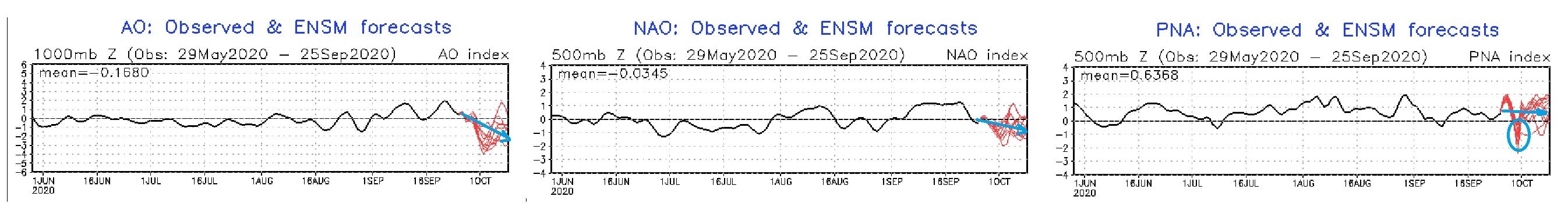
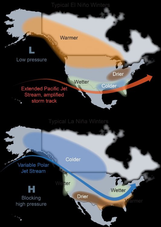
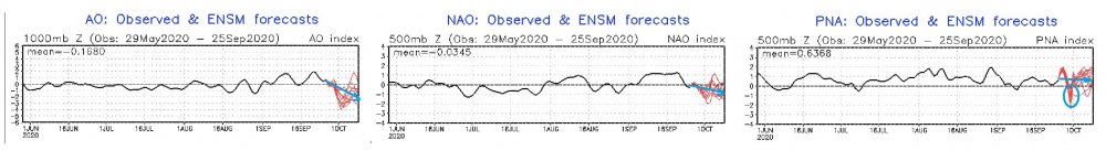
Bingo! Yeah they're a gov org - they can't make supposition? Not without huge problems - lol... So, yup ... I don't mind the 'leading prose' ( if you will ) so much, if at least it can be vetted through a modicum of analytics... which this does! Both apriori but education combined. Anyway, for the general readers, I love their ( apparently negative rendering when copy and pasting) image acuity and simplicity as reference ... Keeping in mind, I think these base-line states are being disrupted by the expansion and velocity stuff as we are describing... So, perturbing and adulterating these looks ... yup. how? million dollar question. I strongly suggest that the straight up ENSO statistical correlations are in trouble... We've had modes on either side of warm(cool) in the last 12 years with apparently limited impacts around global notorious climate zones .. but here is the base... Know what is funny about this... It's odd to me that our best snow winter comes at like +.2 NINO regimes ? when this image smacks as though -1 would be the big nuts... Interesting -
-
That is the SST correlation with the wind pattern stuff.. https://science2017.globalchange.gov/ ... corroborates as well, and discusses the atmospheric modal changes that have occurred in the past 30 years as part of this total response in the global hemisphere - Hadley Cell is an atmospheric eddy that girdles the tropics and subtropics around the planet...featuring ( in the means...) rising air near the Equatorial Monsoonal Trough zones and augmented by MJO ... etc..., polarward mass flux from convection deposition in the high troposphere, and downward ambient flow tendencies in the midst of subtropical ridges ... On the polar side of these ridges, the flow terminates to the westerlies band, the demarcates the interface between the Hadley Cell and the Ferrel Cell, which is the polar cell that orients at higher latitudes ( lower if talking about the southern H. ). The HC expansion is noted in the atmosphere - Refer to chapter 5: 5.2.1 Width of the Tropics and Global Circulation Not to laboriously reiterate but...the expansion of the HC is butting up against the lower Ferral Cell where cold hypsometric layout and compression resulting, is causing enhancing wind velocities as the balanced geostrophic response. In fairness, the article/content may not describe this latter wind response outright - and I have been clear this is my own hypothesis, but it is a damn good one! Regardless of refutation as to cause, the previous "stable" climate R-wave climatology is in peril during colder seasons, because wind speed in the wave mechanics is physically instructive regardless and we have had velocity and gradient saturation ...regardless of ENSO and other factors - it's become a base-state. ... Couple of plausible examples of altered R-wave climate: NAO blocking rarefied because blocking constructs are inherently more difficult to maintain in excessive X coordinate wind. Also, tending to fold the top latitude flow over mid latitudes, earlier in Autumn exaggerating early cold loading into Canada, as well as upon exit in springs. So, if we negate this shit in our seasonal outlooks and/or even modeling -based weekly forecast visions... good luck .
-
Would anyone happen to know where CDC is hiding the PNA/NAO/WPO/EPO product suite ? You go here, "https://psl.noaa.gov/forecasts/reforecast2/teleconn/ " And you are greeted with this, " Note: As of 23 September 2020, the Global Ensemble Forecast System has been upgraded to a much improved version 12, and this page is now obsolete. New reforecasts are available via Amazon Web Services for free download, at https://noaa-gefs-retrospective.s3.amazonaws.com/index.html, and you are directed there for data access...." But that link is an endless maze that frankly doesn't appear as though any engineering effort really had user accessibility in mind.. Am I simply overlooking - or... I am toying with the notion - either way - that this is just another example of bleed-over incompetence from the cultural influence of a kakistocratic government apparatus that swept in upon the election 2016, which began stripping institutions of wherewithal. Consequently, there are less professionals there that either care, or, know what the f* they are doing -
-
Drought was never an issue around New England
-
Smoke + solar min = early flush ?
-
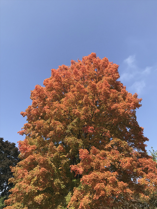
The 9 years I've lived at this location... this is typically the complexion of this tree on or around October 10... reaching pinnacle expression around the 13th or 14th of the month... This year is an early anomaly by 2.5 weeks... That's "pretty" substantial -
-
It's an excessively charge and sensitive flow due to higher energy/potential available.. Early season trough expression is imposing an enormous gradient between the polarward side of the polar jet, dipping to almost the OV as it is... and the lingering summer tapestry that is roughtly SFO -HAT remaining... Small perturbations that tap into that latent potential may be blowing out of proportion..that pressure depiction there appears constructed out of that as it is unnaturally discrete relative to the surrounding integration - it is actually does sort of look a little like a captured tropical entity without actually having had one being captured - that's usually some sort of a-bomb feedback BS in the model(s) when we see this -
-
This is for early awareness only, for enthusiasts and on-going interests therein. Nothing specific ( yet ) to hone in on, but the canvas is certainly there in my opinion .. and a growing impression/expectation for an early winter-like weather expression. The proceeding is based upon personal environmental awareness and teleconnections, combined. As most are aware, the recent operational model types have unanimously all been signaling an anomalous +amplification mode of the Perennial North-American Pattern heading into the mid range, and extending beyond .. well into week-2 .. for many day's worth of runs. As a foreshadowing suggestion, I don't see why an exaggerated early season PNAP pattern, oscillating between neutral to above normal - won't persist very deep into next month, as prescribed the bevy of teleconnectors/tools therein. In and of itself, western ridges and eastern troughs happen at this time of year and they do not have to necessarily signal much. But we have more to consider. ( As hypothetical side note ... where/whence the solar clock has all but extinguished the sun's ability to offset early season cold loading into the N. American continent ..., that normalcy is happening through an ongoing smoke/particulate aerosol surplus - prooobably that has alleviated and/or dispersion extinguished in recent weeks... But, how much so, and ..I also want to point out that the coupled upstream nature of this flow orchestrates yet another period of ginormous heights over the western U.S. - that anomaly will bring a resurgency ( to some "degree" lol ) of enough dessocating heat .. working on a landscape still reeling from the earlier amplitude of similar thematic arc which brought 101 to San Francisco while it was snowing in Denver! And unfortunately more fires that will add to this dimming study. Particularly above the 50th parallel, the governing pattern combined with seasonal solar loss, combined with cooling insolation sheltering.. may play an interesting feedback role in augmenting the air that does pool into climate loading region(s). It may be a subtle ...almost too subtle of a factor to readily quantify, but the "synergy" of finding the cooler solution at least excuse might show up in the gestalts ) We have seen this type of pattern evolve more frequently than not ...since ~ 2000, during autumns. This is the multi-decadal trend, and it is one that is autumnal. I have floated numerous "science-fiction" as well as plausible hypothesis as to why this is occurring - and the foundation for those insights is both apriori, existential...as well as empirically based ( found here in chapter 5 as a primer - https://science2017.globalchange.gov/ ... https://science2017.globalchange.gov/chapter/5/ ) .. So tfwiw .. this year is following right in with this trend-signal. I don't see any reason to offset the assumption that October ( and probably November too - ) will write their chapters similarly with cold incursions that are either interrupting otherwise normal or even slightly above normal temperature departures as intervening. Each whiplash cool back could snow... Part of climate change ( hint hint ) was modeled over the generations of the science, to be hugely variant. Having big temperature oscillations either side of the polar jet in October is too obviously related to that to ignore... Leave it at that. The teleconnectors: ... These are the GEFs-based ones. I find it interesting that recently an increase ( supposedly ) in the capacity of the GEFs for longer range prediction ( and methods therein) were brought on line, and then almost immediately I've observed a rather impressive 'adjustment' toward a colder complexion - one that ...frankly fits the multi-decadal trend. ... I suspect the imm (left) dip in the PNA is probably in the process of correcting less ...how much .. either way, the longer term mass of the members/mean therein suggest the PNA is attempting to maintain a positive bias. There is no MJO modulation of this coherently available at this time - This somewhat reminds me of the early season teleconnector spread that lay in wait ahead of the October 2011 snows that took place that month. Not sure if folks recall or not...that was not so much of a fluke relative to pattern - it was only a fluke relative to climatology. Fact of the matter is, the EPO/PNA-NAO arc all were aligning a cold pattern week(s) prior to the big event, and... there was a sneaking appetizer snow fall and puffy wet aggregate event that car-topped a chilly afternoon and early evening a week prior. So, the signal was successfully ferretted out of the teleconnector spread ... as the combined weigting of two concurrent cold events in the same period was formulaic and not just weird. I frankly don't see that we are in a different climate mode compared to 9 years ago ( I can't believe that was 9 years - wow ). It seems the unusually fast flow is building early seasons heights over western N/A ...exaggerating early season cold loading potentials and ...eventually Octobers and certainly Novembers, the dim solar insolation combined with that augmented curved flow becomes over bearing and climate suggestions are falling increasingly by the wayside do to the weight of those concurrent factors. Here we see a teleconnector spread that is set in ( whether by upgraded GEFs or not...), and given decadal trends combined with other environmental factors perhaps more hypothetic.. the table sets in my mind to snow in October yet again. Hard to imagine perhaps as I type this in 83 F heat ... but, this warm spell now and over the nearer time ranges was also well handled by the models, too.
-
Snow in October
-
It's hard to imagine ...given that trough's scale of anomaly and apparent persistence as suggested by modeling ...how any region from the SE to the NE U.S. is going escape raining episodes after ... Day 4 or so... Thing is, that trough still is not in the near term..it's still mid range...
-
This always happens on Oct 10 ..huh, ...I mean...with that salmon mix zone? That's like riding a winter cyclone up a cold wall, mid winter form ... not just some dynamical core of cat pawing there Here's the problem I'm having with this... I think it is more plausible now, than it was in 1980 [ enter climate modulation/causality here ] For one, ... decadal trend: forget geophysical reasoning/mechanism, it's snowing in Octobers some 1/3 to 1/2 of the years since 2000; prior to then? ... just existentially off the top of the head ...maybe 3 times in 30 years. Something is promoting these early season "folded synoptic" flow constructs - which is just personal labeling of a phenomenon to arc the flow in western Canada and concomitantly plumbing heights S over the eastern continent - as an autumnal affliction.