

Typhoon Tip
-
Posts
44,532 -
Joined
-
Last visited
Content Type
Profiles
Blogs
Forums
American Weather
Media Demo
Store
Gallery
Everything posted by Typhoon Tip
-
Right on schedule ... does this every year about a month past the solstice ... It's the same thing going the other direction in late April. The front side of summer the model behaves as though spending the two week's worth of frames trying to scrub the added seasonal warmth out of the atmosphere - like ... I dunno, the sun must be an error? About mid way through summer it starts hurrying autumn onto the scene. I noticed it begin doing this about 7 or 8 years ago. Not sure why it does this, but I suspect it is related to why it is always the cooler of the three model systems, GGEM, EPS ...etc. By D4 or 5 it's around 1 to 2 ( almost imperceptibly so ...) cooler with these non-hydrostats below, on the polar side of the ambient jet, and from there it ends up around D12 sometimes 10 colder within the SPVs and general PV well. Euro cluster left, GGEM middle... GEFs mean is on the right. You can see just eye-ball test-wise that we are integrating a cooler PV template at the far end of the model run Summer's not the best season to point this out, but there is slightly more cold in the GEFs there above. - but it begins effecting pattern morphology sooner then 300 hours, particularly so during the winter. If we make this comparison on January 15 it's a bit more noticeable. Winter probably gives some sort of harmonic feed-back between the model's gradient production, on top of the fact that we are in faster velocity soaked state of winters already, anyway, due to the big C-squared. The GFS just has a speed bias man, one which really should be there if there is even modestly too much gradient between 70N and 30N around the globe - creating a surplus cool height on the polar side of the ambient jet seeds that circumstance. No one's seeing it ( maybe?) because we're setting air-land speed records with intercontinental flights and observing 200mph jet cores as it is. Which I wonder if that circumstance is masking matters... Or perhaps even an emergent error quotient because the model tech, despite advances, is up against it when balloons go around the globe at 1/3 the speed of sound in the winter... i.e. fast is error prone
-
Occasional Thoughts on Climate Change
Typhoon Tip replied to donsutherland1's topic in Climate Change
What most know to be true already but yup - https://www.science.org/doi/10.1126/science.adp0212 -
things are on par in the tropics right now. god lol
-
It’s an unusual behavior actually, relative to 500mb summer climo. That aspect’s under the radar. Its a February ‘hook in latter’ weird
-
Yeah I was just gonna say ... we've had some other gems this summer ( definitely more than that abysmal summer, last year..) but this is right up there with the very best.
-
Not sure if this was mentioned but Monday was the new 'hottest Earth day' ever measured/calculated continuing along a string of such days. ( https://phys.org/news/2024-07-monday-warmest-day-earth-scientists.html )
-
That cut off low looks worse than it really is… I mean it’s only about 582 at nadir and because it’s happening at a very elevated ambient height field. In fact, that may not even represent below the middle levels and even if it does, it’s probably gonna be more east and south of it 18z gfs looked weaker yet
-
I don’t think we spent any time in the 60s and 70s… We went right from the 50s to the 80s this year Oh… You meant those decades
-
sorta odd looking. models are attempting a warm if not hot lower troposphere during a pattern whose geometric layout/orientation is somewhat inconsistent at a glance. I guess the 850 mb is just warm regardless
-
peppeRONI may just overwhelm the meal this year
-
I dunno tho. ..mmm I think the wider variance of the earlier climate model warnings may just be arriving. See ( op ed) the problem I have with this is that these weird super deep cold snaps that have been happening into middle latitudes around the winter hemisphere, during winters that are on average warm and getting warmer. Or, the synergistic heat waves that appear to launch temperatures higher than any leading/modeled indicators argue they should extend, at any time of year now really - These are perhaps just the coherently obvious impacts of CC, which are like rogue waves in a sea of subtler disturbing waves. (Sorry, I love metaphors ha) Basically, moving the dial a degree in C may in fact be integrating both subtler changes, along with disproportionately larger anomalies than one might expects. You ever get insulted by someone clever enough to make sure you don't realize it until you've left the room? I feel sometimes like the majority of climate change is a silent insult to our expectations, almost so gradually ...we don't realize we're being mocked. ( a little sarcastic license here but still ) It's a bit of philosophy but it really appears more and more to me like CC's rising temperature, as an anticipation, really needs to be redrawn around rising chaos. Remember those early lectures where scientist warned that crossing thresholds can also happen silently? I will tell you, I began posting observations related to the increasing gradient in the H500 mb hgts during winter. - if we really try hard we can see how inconspicuous phenomenon lurk. And that gradient increase, even in 3 to 6dm in the N-S integral, introduces a speed-up in the rest state velocities of the atmosphere ...--> forcing pattern and pattern-contained event morphology.
-
Lol, okay but just in case ... I was speaking to the general audience. Not sure who said what or in deference to any context
-
I'm suspicious over whether we will settle back. General op ed: The super Nino of 1998 seemed to " reset " the global temperatures, one that also appeared to be permanent? I'm not abundantly sure on that, but now here we are 25 years later and we are not returning in 1996, so ... Much in the same way, it makes sense to me (intuitively, for reasons below) that this more recent "resetting" event should be both more permanent, and notable. Why? we are also in a D(D(climate)) mode - a notation I'm using to mean accelerating. The antecedent multi-year Nina was suppressing an accelerating curve. That is perhaps analogous to pulling the rubber band extra taut. In other words, ... we needed to correct for more than just an erstwhile linear climate change suppression. It was that plus compounded interest - so to speak. As an aside ... I've come to find that even well-intended people of the general consilience, we don't seem to consider actual acceleration - at least not enough. Not just the amount, but the concept of what acceleration really means. There is a spectrum there, where at one end is direct responses, and at the other is more and more indirect responses - those that are due to synergies and feed-backs giving rise to emergence that by nature can at best only be vaguely anticipated. That unfortunate limitation and reality should really lower a lot of assumption confidences about any existing total response model. More so than I get the sense is really happening. More anticipation for "surges" and corrections need to be assumed if not anticipated. That is a tricky prospect. How does one cogently describe needing to anticipate emergent properties that are not presently knowable, in a crisis where what is already known is thought to be controvertible. Good luck ... Anyway, back to point. It probably makes sense that an accelerating climate change may observe in subtle or gross surges ... at other times, more smoothly. The planetary system is "jagged," with offsetting complex physics. If any one of those processes are transiently scaling a larger effect in the total system - masking the longer terms more persistent climate change - than alleviation of that effect would likely result in an more rapid restoral to the previous dynamic. Sometimes appearing abrupt.
-
I poked in while on vaca and happen to catch your post in the matter. You said, '... tue and wed ratters'
-
Yeah everything's "feels" like this or "seems" like that when it comes to people's moods and attitudes about sensible weather ( helping to modulate their climate awareness...) And this provides a delicious plate of items for people to eat arguments over. We've had this disco/debate in the past, but in short ... given enough acclimation time, perceptions will tend to separate more and more from empirical/objective data. It's the +D(meh) effect. LOL However, June was ~ +5. + 5 July appears destined to the same result. Purely constrained by thermodynamics that are natively associated/driven by season, there is a quasi floor to how cold it can get in winter, and likewise a ceiling for how hot it can get in summer. In order to average -5 or +5 respectively ( to mention, for whole month's worth!) is something of an impressive achievement respective of season. Regardless of however tenuous one's perception of objective reality is or not, this is a blow torch summer. But ... I suppose that subjective aspect has to have the near crisis run-in with physical exposure to 107 F before they believe that. This is part and parcel (example) in my non-obligatory, GW plausible deniability theory. Human beings, like all other biologic life on this rock where ( apparently ) is the only place in the cosmos where that actually happens ... are programmed to respond to whatever it is they see, hear, smell, feel, or taste, probably in that order. These are the "USB" ports that connect our "CPUs" to nature. Global warming does not directly appeal to these corporeal senses. Humans are "supposedly" capable of perception not purely constrained by what is arriving through those signal feeds. It just appears GW moves too slowly and frankly, doesn't cause enough inconvenience to really resemble a case for truth. This enables people to land their perception just about anywhere along the spectrum of denial there can be ... which ranges from hard core bloviation, all the way to admitting something is wrong but doing so in a divisive manner where their word choice and/or behavior ultimately achieve the same disregard. In short, too many people have to BE physically injured by it. Morning rant completed -
-
Nasty heat wave potential D8+ but I'm not sure/confident yet how far N-E it gets across the conus. The flow geometry through the Canadian Maritime is orienting or reorienting into zonal out there in time, while the PNA "should" be sending +PNAP structure across mid latitude continent. The the problem is, the operational versions of the models keep trying to sag the mid and u/a into some sort of heat walling off vestigial trough sag in the western OV. This being beyond D7 is allowing plenty of time for a correction in that matter. But the WPO--> EPO/PNA is a pretty darn hot signal for us. ens tele inferred hgt anomaly NE-E of HA teleconnects to relaxing the semi-permanent ridge over the Rockies...and with said NAO orientation, the correction vector points N with the heights right where these op versions are sagging. Definitely a lot of summer seasonal entropy in the hemisphere. Coherence is at a premium so it's tricky.
-
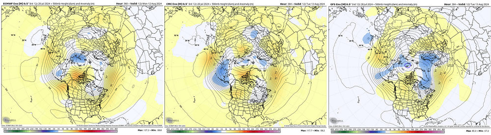
Models et al tend to perform pretty well up through 48 hours wrt temperature outlooks. Not trying to sound dismissive of any monitoring efforts there, but is only to say that it doesn't surprise me. What I find interesting - tho am not sure of the/any significance - is that all the ensemble mean distant outlooks wrt 500 mb height anomalies, GGEM, GEFS or EPS, all very persistently end up on a positive ledge. This has been going on for years actually. Seldom do we see these ever negative... ex, 360 EPS mean anomaly from 00 ( or any run... ) looks similar - This products from all three major sources ... I don't recall the last time their mean coming back to neutral way out there in time. Again, I'm not sure if there's much operational value to this observation, but ... I think it is interesting that we seem to be verifying the dailies about the same amount of lower troposphere total positive anomaly, as these distant outlook products ( proportionally ) are positive.
-
I suspect RONI or RONI-like offsets, in general, will force some of this anyway
-
It's a good thing we're closing off that low SE so we can hold onto a snow and mix ptypes
-
amazing... That must be excessively localized. Our lawns are pretty good down here along this end of Rt 2. Both those and open field expanses. They're doing summer Lacrosse on mainly green. etc... I was just thinking to my self yesterday that considering June was +5, and July appearing destined to similar, it's interesting that we are so green relative to those departures. Might expect more summer tanning for getting that warm. Maybe we've just been luckier down this way.
-
I’m not super impressed with heat wave signals after about Augie 10. We get them sure, but the solar calendar is beyond the max so any 20C 850 is just not going to result the same as it is prior to that ~ escape.
-
GFS is flirting with it about every other run. But even on the hot runs it then goes out of the way to immediately pack the heights into the west 10 minutes after we’ve finally ridged. Euro’s been sorta like that too.
-
6 hr heat wave
-
Folks may be adjusted so far that they’re sensibly interpreting a nadir of/to normalcy as an actual cold shot ? Which “cold shot,” although entirely semantic … really should be reserved for actually below normal. I came over the Berkshire divide today. The valleys around ALB were as high as 86 on the dash … then it was 73 over the crest at 1750’, back into the low or mid 80s by the time Springfield went by the car. Been off the weather juice for over a week and the only thing as refreshing was the appeal of that as being entirely a 30yr/N terms kinda day. … Minus the last 10 years worth of variance mania so vast one cannot even trust the means.
-
I believe we are witnessing the models with a synergistically ( wave harmonic) improved ridge event in this scenario. Not being over land is probably a blessing. These are found in the vicinity of notable surface heat bursts that have been occurring with increased frequency dappled around the globe. They are atypical to normal summer positive anomaly behavior - though do preferentially occur during the spring and summer months. Where they do, surface temperatures may soar well beyond guidance/machine based interpolations.


