Typhoon Tip
-
Posts
44,539 -
Joined
-
Last visited
Content Type
Profiles
Blogs
Forums
American Weather
Media Demo
Store
Gallery
Everything posted by Typhoon Tip
-
Heh ... he thought he was lobbying a shock jock statement at us, but not being connected to reality so much of the time as he is ( by choice it seems...) left him kind of short on the fact that ... yeah, we're doing that anyway. hahahaha
-
-
Here's my excruciatingly nerdy assessment ... The pressure pattern at the larger synoptic scale observation shows that the high pressure over western and lower Ontario, behind the front, is actually the same as the pressure layout SE of the front associated with the WAR aspect. Normally that's consistent with a stationary front. However, there is a small gap where the boundary is geometrically biased N-W of that axis in between - hence the apparent N wind prior to the frontal arrival. This gap will likely be were the front lays in and goes stationary... Prior to that happening, there is a local pressure perturbation effect as Brian pointed out with the convection over lower Maine... it's giving the boundary a kind of meso scale momentum down the SE NH into NE Mass. It just means for eastern zones, the front arrives several hours earlier. By this evening, the front will likely be somewhere near the Pike... or whatever
-
They'll probably end up through your living room picture windows (or worse) if they are "west" of you ..um, be careful what you wish for. what you said is akin to sitting out on a tree limb while you saw it off -
-
yup...just going to post that COD high res clearly shows some sort of scouring coming into Essex CO down here now. It's probable that our built in non-linear forcing will convert the eastern end of whatever we want to call this boundary ... into a BD and that'll be the final nail in this heat waves coffin. Might even cool off down here over eastern Mass before MHT in the old wrap around
-
Let's get the TCU tower machine revved up so cloud geeks can gawk !
-
...I'm wondering if the gradient, albeit very weak, is N and the front is still not through. WPC 10:30z analysis still had it near PWM ... maybe it moved that far S but without a wind pulse that seems odd? It's probably a moot point on the coast anyway. Soon as it starts to hint at heating up in the interior Logan is going to be ENE at 15 flag snapping kts regardless of where the front is so what's the difference -
-
Signal for heat return toward the end of the month is trying to decay. Not sure that means it's really going away. The telecon ( numeric ) spread are still modestly biasing the NAO positive, while the PNA is modestly negative, from the ggem, gefs and eps sources. The concert of those indexes correlates to some warmth penetration to mid latitudes over the eastern continent. It's just a subtly more modest now that previous trend. May not be significant enough to even read this but I've been finding over the last 5 years that whenever I see a very subtle variance, and figure it's too little to mean much it's ended up being the whole story with shockingly creepy high whatthefuckist correlation -
-
we were on the western end of that ... looked like lag-back anvil deposition after an initial small cell on the MCS outflow developed and dumped .25" very fast. But that trailing blob carried on for a couple hours and gave us to .6" or so total. Needed.
-
Any reason imaginable to shorten heat in New England Whenever a pattern like this and that evolves, you figure there is a 100% chance of something happening to steal 18 - 30 hours off the front or aft end of the duration ...while having almost 0% chance of actually knowing why that will be. The model runs from about 4 days ago began suggesting the front would sag S and end things on Friday, when just prior to that they had the heat going through the weekend - altho attenuating some. I began arguing all week that the mid level flow/synoptics did not support a frontal position that far S, without conventional mechanics ...under those big heights. I do recall mentioning that the models seem to be confusing the outflow from convection bundling ( perhaps ) as the front. What's interesting is that the shrouded transparent low scud at dawn are moving S as though the front did go through but according to WPC it is still hang up near or N of Brian ...which is where the mid lvls suggest it should be. Interesting saga with that for nerds like me.
-
Look what the MODIS network has at Ray's old house ...
-
My company ...which does high intensity voltage wafer prefab/high tech, was just informed by electric provider to scale back thru 8 pm. No reason specified but heh.
-
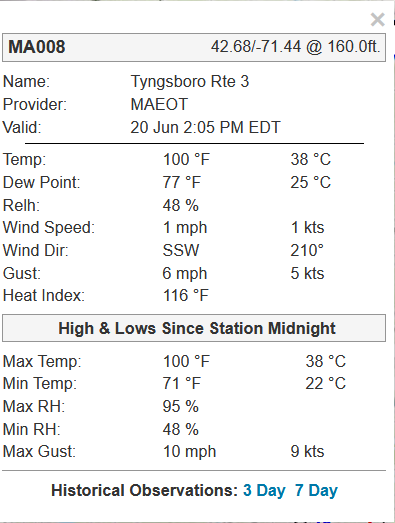
99 MHT
-
3 minute W oughta do it
-
someone's gotta ping 100
-
Not to be a dick but I have felt it worse. That late June 2021, the one that fried my kitchen refrigerator and blew out my window AC on the same afterfuckumnoon was right up there. It was 97/79 as I recall on the average/Davis' one of those afternoon in that 3 days stretch. But yeah, this is pretty awesome. 98/76 here and 96/75 on the MODIS ob at the Oxbow and there is less breeze than yesterday- so very little ventilation amid 110+ HI is a miserable picnic
-
heh looks like failed leaners to me so far
-
we're about on par with yesterday relative to hour but it just edges worse today. I'm wondering if the DPs are just 2 to 3 clicks warmer and that's the difference. might have to break down here and spin up the AC before end of work hours. something i don't like to do. fan isn't cutting it.
-
NAM keeps the boundary along Rt 2 ...sort of diffusing it a bit, too but the time spent with E wind at Logan has been shrinking, and is shrunk down to just 4-6 hr pulse and it's weak on this run before coming right back around S. But this is trended(ing) ...unknown if it's finished doing so. If not, there's a chance this frontal positioning was bs all along. I've never frankly liked the model position ( all of them ...) given that it looked like it was too far ahead of the height receding - we'll see.
-
Finally seeing some towers albeit small... thing is, the heat's so intense that things can go quickly. Like a small couple of pixels white cu is an anvil in two frames. Hunga Tonga–Hunga Haʻapai style
-
yeah, I can't tell in these light wind/high heat deals. the homes sites ( 5 of them ...) about 1/2 mi from my pad, two of the are 80+ and 3 are 75 to 77... Yet FIT is 73. I guess it is more miserable at our homes then these ASOS? I'm not sure I buy it that they are all bad sensors but who knows -
-
Do you think that DP is legit ?