

Carvers Gap
-
Posts
17,401 -
Joined
-
Last visited
Content Type
Profiles
Blogs
Forums
American Weather
Media Demo
Store
Gallery
Everything posted by Carvers Gap
-

Fall 2021 Thread (September, October, November)
Carvers Gap replied to Carvers Gap's topic in Tennessee Valley
Leaning towards an ensemble head fake this AM regarding the return to cold after this weekend's amplification. Lots of modeling(too lazy to name them all) are beginning to show BN heights over Alaska with fading BN heights here. BN heights over Alaska generally teleconnect to a warm SE. The Euro Weeklies eventually re-drop the hammer during December in regards to cold here. Message today....cold this weekend, more moderation than was shown last week both in terms of warmer temps and duration, and still cold for the middle part of December. Again, this is shoulder season so things will be all over the place. Jeff's comments above pretty much explain what is driving the change. The IO has been an absolute thorn for several years...I don't see this winter being any different. Huge grains of salt though. Models probably are not done bouncing around. November can be an incredibly difficult month to model as cold/warm pools(new cold pools/diminishing warmth) are moving thousands of miles from their summer latitudinal norms. Wavelengths are changing. This is dice stuff. At least this time, we kind of know that really cold looks past d8 often verify -----but just not in the place where originally modeled. -
Fall 2021 Thread (September, October, November)
Carvers Gap replied to Carvers Gap's topic in Tennessee Valley
LOL. I have no idea what a cold look Fountain is(maybe spellcheck derived it from "forecast"???)....Probably should have said that is a cold portrayal by that model since model output is technically not a forecast. -
Fall 2021 Thread (September, October, November)
Carvers Gap replied to Carvers Gap's topic in Tennessee Valley
Way, way out there but the 12z Euro ensembles show a very cold pattern at 500. Source region might be lacking at first, but if that holds....it could tap some really cold air from over the top. We have seen this several times during the past few years as a head fake, so I am holding my fire. However, I like what I see from this far out. That is a cold look Fountain! -
After accumulating snows on Mt LeConte yesterday, the lower elevations in Kingsport are dealing with heavy fog and our first killing freeze. Visibility this morning was maybe 100' in spots downtown. Needless to say, frost on the ridge lines above the river is heavy!
-
Seeing some photos of snow above 5,000'. Looks awesome. If one of you all Twitters, put a few posts in here!
-
Fall 2021 Thread (September, October, November)
Carvers Gap replied to Carvers Gap's topic in Tennessee Valley
Man, it feels like winter out there. And the ensembles do not look warm after d10. Monster ridge going up right along the West Coast. Give it a few more runs, and I might be read to say that winter is about to begin north of I40 during the second half of November. Now, that doesn't mean snow necessarily, but it does mean we are about to flip cold. @Blue Moon, were you in this area for a time? -
Fall 2021 Thread (September, October, November)
Carvers Gap replied to Carvers Gap's topic in Tennessee Valley
Maybe first high elevation snows next weekend? Euro looked robust for the northern Plateau and Smokies. Interesting track with marginally cold air in place or sliding in as precip arrives/departs(we know the drill). -
Fall 2021 Thread (September, October, November)
Carvers Gap replied to Carvers Gap's topic in Tennessee Valley
Aaaaand, the Euro Weeklies have flipped back to a cooler November just like that. Shoulder season is a bear for models which attempt to portray patterns after the normal 16 day look. Looks a bit blocky which might also be contributing. Almost seemed like the last run had a similar start to the pattern, but broke it down too quickly. Again, I would not be surprised to see the cold dump into the West and work eastward(that is much more likely in Jan and Feb). It is decidedly colder at the surface which is unusual as it has an AN bias after week 3. The other thing is that it was derived from a pretty cold run yesterday morning which does impact the full run. -
Fall 2021 Thread (September, October, November)
Carvers Gap replied to Carvers Gap's topic in Tennessee Valley
East Coast. Still looks like a major trough amplification for early November, but then reverts to a trough out West. Now, one word of caution is that the Euro Weeklies REALLY struggle during shoulder season. They can do quite well with individual events like next weekends EC trough, but they can miss the overall pattern at times. I was just saying that it does not shock me to see the weeklies flip back to an western trough. There has been a real bias of late where it places a trough over the eastern part of the US - only to have it dump the cold out West. Honestly, I would be fine with a cold shot in early November just to get some fall weather, and then have it warm-up for a couple of weeks. The best case scenario for a cold December is a late November flip. But right now, huge grains of salt are called for when dealing with the weeklies. -
Fall 2021 Thread (September, October, November)
Carvers Gap replied to Carvers Gap's topic in Tennessee Valley
Euro Weeklies for November...yep. Looks like it pushes the potential for a better 500 pattern later into November. Been a huge bias for several years. At least this time we kind of knew the potential. The good thing would be that a later flip to a more seasonal pattern would mean that much of December would be included in that pattern if one holds to 4-6 week pattern cycles during winter. -
Very persistent Hudson Bay block is also there. During winter that would be money if not too far south. Right now, seems to just be funneling north Pac air across the US and maybe tap Alaska from time to tome.
- 167 replies
-
- 1
-

-
- frost
- cold front
- (and 4 more)
-
Euro Weeklies are out. Still a fairly good signal for seasonal or slightly BN temps for the SE. @nrgjeff, most of the teleconnections look neutral after the next week or os. Best I can I can tell is many the -WPO is helping driving the pattern some in terms of teleconnections. I imagine the climatology for Nina is also driving the look in modeling.
- 167 replies
-
- 2
-
-
- frost
- cold front
- (and 4 more)
-
Fall 2021 Thread (September, October, November)
Carvers Gap replied to Carvers Gap's topic in Tennessee Valley
A bit of a lazy comment upcoming....lots of modeling is foreshadowing cooler weather right at the end of this month and into an undetermined time frame during November. Source region is in question. However, pattern amplification into an EC trough is growing more likely as several models and their ensembles are supporting this pattern along with some Weeklies modeling - notably the Euro. See commentary above and someone go get Jeff out of banter! LOL. j/k. Nothing is a slam dunk at this range, and we all know modeling will often show an EC cold snap, and then it dumps into the West first. That has been a model bias during the past several years. Plenty of talk of an early strat warm event. John mentioned that in the winter thread I think. Some great discussion there. -
Fall 2021 Thread (September, October, November)
Carvers Gap replied to Carvers Gap's topic in Tennessee Valley
18z GFS shows the potential for the late month pattern and early Nov pattern(though it doesn't quite get to Nov). Deep trough amplification and a phase along the eastern seaboard which(this far out) could be anywhere. I think the chances for a powerful coastal or inland runner are there. -
Great post by John there. Going to post a couple of links for why we double dip with La Nina's and a graphic of how the second in the series is usually weaker. Also, great ENSO update today in regards to winter. Lots of great stuff in those links. Great disco past few days! https://www.climate.gov/news-features/blogs/enso/double-dipping-why-does-la-niña-often-occur-consecutive-winters https://www.climate.gov/news-features/blogs/enso/october-2021-enso-update-la-niña-here?fbclid=IwAR04Y3Kpyl8pTfS19Uy0XuBKxxPVPWLuQ9tlGV7VbBSvpTNijCerDvFLKEU
-
Fall/Winter Banter - Football, Basketball, Snowball?
Carvers Gap replied to John1122's topic in Tennessee Valley
LOL. Posted something similar in the fall discussion thread on Monday. On second thought, banter was probably the better choice....but it was a slow day. Kind of unreal how nice the set-up for the time frame is! And yes, huge grain!!! -
I think seasonal models have struggled of late due to analog packages not working. We have seen a lot of "opposites of what we would expect" during the last few years. I do think this La Nina may "reset" the Pacific basin for a time(future winters/not this one), and allow traditional analogs to have some merit again in the future. No idea if the GOA trough holds. It can be stubborn to move. Looks like it is on the GFS right now, but this is still mid-fall so no worries at this time of year. I am guessing that the Euro Weeklies may be favoring a moderate-ish La Nina - I haven't looked at its SSTs so just a guess. If so, that would explain the torch over the East for much of winter...but again, the last few winters have not not played nicely in regards to traditional wx patterns. I would suggest the IO and western Pac will still have a say here. If the MJO is the driver, La Nina may well make it tough for waves to propagate into phases 7, 8, and 1 - will depend on how far back the La Nina stretches to the West. And again, La Nina's behave differently over the forum area. Last year was a fantastic example. Memphis was downright frigid and snow. Never really made it to TRI after the Christmas week cold in December. Would not surprise me to see a similar pattern repeat.
-
Fall 2021 Thread (September, October, November)
Carvers Gap replied to Carvers Gap's topic in Tennessee Valley
Euro Weeklies continue to strongly hint at an eastern trough amplification during early November(second week?). Would involve blocking in Greenland hooking in with a PNA ridge which creates a broad area of banana high pressure over NA. Honestly, that looks like a winter storm set-up for those a few degrees in latitude to our north and for our higher elevations. Would not surprise me to see an early season snow in those areas. Still likely a little too warm here due to climatology, but wouldn't be surprised to see some flakes in the air here. -
Euro seasonals look rough. To echo Cosgrove, wx models really like a GOA low. That is no beuno for here. Biggest feature I am seeing is a ridge over the eastern US which persists as a dominant feature for the next 4-6 months. Very little encouraging in that run - like zip.
-
Fall 2021 Thread (September, October, November)
Carvers Gap replied to Carvers Gap's topic in Tennessee Valley
Euro Weeklies in addition to the seasonal CANSIPS, banging the drum for a fairly significant high latitude blocking pattern to develop later this month and into November. Basically, a HB bay block builds into a Greenland block. Euro Weeklies are generally always warm at the surface, but the pattern at 500 is one that would bring significantly colder air at least to the western slopes of the Apps if not all the way to the EC. Huge grain of salt at this range, but there are hints of pattern which could produce BN temps. Would not surprise me at all to see the first snowflakes of the season flying during the first couple of weeks of November. But we will see. That is my "bold" prediction for a soggy Friday morning - meaning seeing some snowflakes during November is not exactly unusual at all and pretty much right on time. -
That would be early. Are early SSWs more favorable for the EC?
-
Torch city. I haven't seen the Euro seasonal yet though, just CANSIPS. The CFSv2 is usually all over the place from run to run. The Euro Weeklies are hinting at some cold pressing SE during the early to mid part of November. My initial thoughts have been for a cold December. HOWEVER, if the cold arrives in early November, we could actually see a thaw at some point in December. LOTS of speculation there on my part as there are several solution paths on the table, and I am only talking about one path in (cold in November). If the cold arrives later in November, that lends itself to a cold December as a whole. Throw in what John is saying and it would look something like this.....cold November ---> thaw at some point during December ---> cold arriving again by mid to late January. What we really don't want to see are the high latitude regions emptied of their cold source during November. Might make it tough to reload, and some models are hinting at that solution. But ya'll know the drill, this is speculation and this could go any of several different directions not mentioned and usually does. Chaos is difficult to predict. When we are discussion things in the 4-10 week range, that needs to be taken (as John notes) with huge boulders of salt.
-
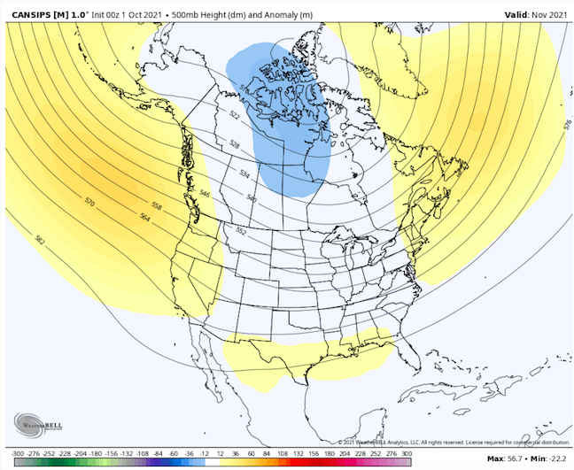
New CANSIPS is showing a very cold pattern for November. Blocking is depicted in EPO and Greenland regions with a deep trough over much of NA. If true, like it or not....our best shot at winter may be very early in the season, but take that with a huge grain of salt.
-
Fall 2021 Thread (September, October, November)
Carvers Gap replied to Carvers Gap's topic in Tennessee Valley
Weeklies (Euro) are showing signs of high latitude blocking towards the end of October. Not sure we want that in place quite yet. Would essentially mean ~6 week blocking episode if we go by 4-6 week pattern cycles. Means mid-Dec could be warm. Way too early to guess that. However, early season blocking might be a good sign for winter...so there is that. Looks to me like the summer heat is gone. -
Fall 2021 Thread (September, October, November)
Carvers Gap replied to Carvers Gap's topic in Tennessee Valley
To echo @John1122 in the banter, starting to see some signs of a temporary breakdown of the EC ridge complex as several storms traverse the western Atlantic and drive the cool boundary every southward. I like it. I like it a lot.

