jm1220
-
Posts
24,560 -
Joined
-
Last visited
Content Type
Profiles
Blogs
Forums
American Weather
Media Demo
Store
Gallery
Everything posted by jm1220
-
Feb 18-19 long duration manageable snow and ice event
jm1220 replied to wdrag's topic in New York City Metro
Comical differences on the models this close in. NAM essentially is all front end snow to sleet and most of the GFS snow is from a coastal storm. -
Feb 18-19 long duration manageable snow and ice event
jm1220 replied to wdrag's topic in New York City Metro
12z RGEM looks pretty good actually, it's a little cooler in the mid levels than the Nam. -
Feb 18-19 long duration manageable snow and ice event
jm1220 replied to wdrag's topic in New York City Metro
Very typical scenario for our area for this-hopefully the snow comes in like a wall, accumulates fast and can hold the sleet off until it's about over. -
Feb 18-19 long duration manageable snow and ice event
jm1220 replied to wdrag's topic in New York City Metro
I don't think they all count sleet as snow. I don't use Tropical Tidbits because I know they do. It's a much better idea to use soundings instead of snow maps and look at the 700/850mb maps. Lots of SW flow at those levels which will produce the heavy snow but also warm those layers up and everything in between. It's usually a good idea to use the warmer mid level temp models in these type of SWFE events since those layers often warm up faster than modeled. -
Feb 18-19 long duration manageable snow and ice event
jm1220 replied to wdrag's topic in New York City Metro
You can't discount the NAM getting warmer aloft. It's usually superior to other models sniffing out these warm layers that can mean changing over. Last two runs have gotten a little warmer in mid levels, no doubting that. It's north of other models generally but there's often a last minute north trend anyway. RGEM at 6z was also a good bit north it seemed. -
Feb 18-19 long duration manageable snow and ice event
jm1220 replied to wdrag's topic in New York City Metro
Heavy snow burst before mixing comes in probably. -
This morning in Austin- significant ice storm. Looks like up to 0.5” ice.
-
Feb 18-19 long duration manageable snow and ice event
jm1220 replied to wdrag's topic in New York City Metro
Well, GGEM definitely on the snowier Friday and coastal low idea. Takes forever but coastal areas get a good swipe from it. Less inland/NW. -
Feb 18-19 long duration manageable snow and ice event
jm1220 replied to wdrag's topic in New York City Metro
Yep, it might just be adjusting toward this being a Friday focused event. We just have to wait and see. -
Feb 18-19 long duration manageable snow and ice event
jm1220 replied to wdrag's topic in New York City Metro
Hopefully you're right. I'm not liking the trends on some models toward making this a 24 hour long sheared out mess. I don't think something like that would end up as more than a solid advisory event. I guess that would keep it cooler for the area but we need the front end thump or the consolidated Fri low idea to happen. GFS and CMC are in sheared out mess land now. -
You live in Queens, that's a bad thing? Looking great down here for now but as others said there's still plenty of time for it to keep going south or otherwise get messed up.
-
Feb 18-19 long duration manageable snow and ice event
jm1220 replied to wdrag's topic in New York City Metro
This is through hr57. Looks like maybe at the very end and when precip is light there can be some sleet near the coast on this run but as you can see it doesn't make a difference in accums. Far northern people may be sweating a little but these always have banding north of where the snow is supposed to stop..thumb.png.b47dd822e40cdcee87ea4017bcc38234.png)
-
Yes and no. Not having power and having an entire million person city essentially shut down for days ain't ideal either. 6.4" of snow is a nice event for me (I saw some areas of Austin had 7 or 8") but I've already had more than that in one event 3x this winter and have a good shot at #4 on Thu. There's no comprehension down there (south of Dallas) how to handle any kind of winter event much less anything like this. The utilities are in some real trouble over how things have been handled. To me I wonder how they handle the A/C constantly being on for months under 100+ degree heat but can't handle this. I know some wires must have been damaged from ice but a lot of what just fell in TX was snow.
-
Snowpack largely intact but some areas exposed to the sun are bare. Shaded areas definitely have a good bit left and we have the huge dirt/ice piles that will get even bigger on Thu.
-
Feb 18-19 long duration manageable snow and ice event
jm1220 replied to wdrag's topic in New York City Metro
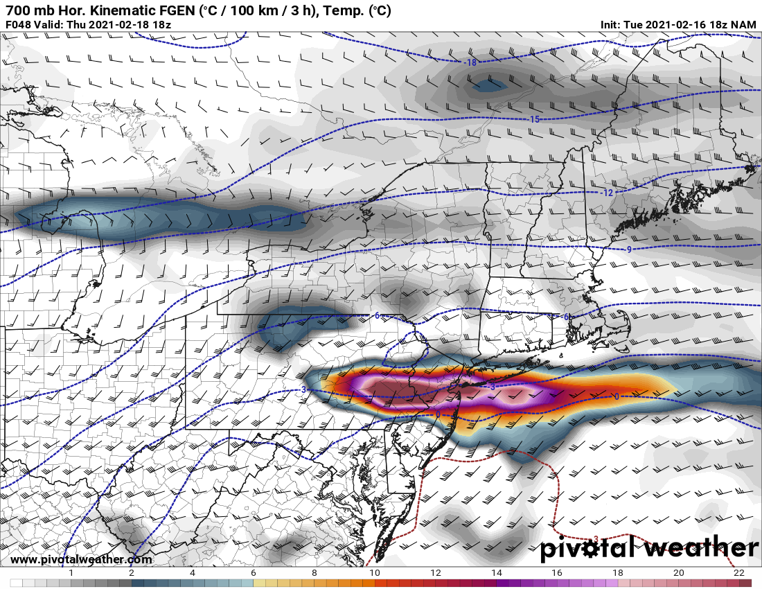
700mb frontogenesis at 48hr on the NAM for 18z Thu. This is exactly what the NYC/coastal areas would need to get a quick 2"/hr thump on Thu afternoon to get 6-8" even if they eventually mix. That would be one crazy snow band. The models now are essentially saying we get this very heavy snow batch for several hours then a lull where the warm air can come in. Central Park needs 6.2" I believe to get to 40" on the season-decent chance of this right now.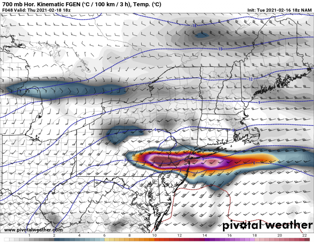
-
Feb 18-19 long duration manageable snow and ice event
jm1220 replied to wdrag's topic in New York City Metro
We have the well placed WAA that brings the heavy snow in on Thu like a wall that makes the 6” totals possible near the coast. If the heavy snow is more scattered or the main WAA is aimed NW of the city, amounts will be less. As usual I think it’s 90-95% chance that at least the city will go to sleet at some point and probably rain. But by then a lot may have fallen already. -
Feb 18-19 long duration manageable snow and ice event
jm1220 replied to wdrag's topic in New York City Metro
Hopefully those models are correct that there could be heavy banding and the snow comes in solidly. As others pointed out the problem in Dec was there was a few hours of good snow then the snow shredded up and warm air took over. I agree that most will change over to no -snow eventually-rain near the coast and sleet inland. Any of these setups where we’re sweating the mid level low tracks end in changeovers. -
Snowpack is holding up decently well here but still taking a big hit with temps near 50 and rain. Hopefully we can salvage a fair amount before the event on Thu.
-
6.4” of snow in Austin, third most on record and most in one event since 1949. Low tonight of 3 and more freezing rain on the way. Rolling power outages all over the city. Crazy situation
-
Feb 18-19 long duration manageable snow and ice event
jm1220 replied to wdrag's topic in New York City Metro
It’s always a question of how the snow comes in-like a wall or shredded. If shredded the warm air advances more quickly and flips it over to sleet. That was our problem in the December storm. -
Feb 18-19 long duration manageable snow and ice event
jm1220 replied to wdrag's topic in New York City Metro
Would be nice but I doubt it. We’re back into a period where the SE ridge is dominating and the blocking or what’s left doesn’t compensate. Nina climo in Feb can only be held off for so long. Should hopefully be a nice 3-6” thump before rain or sleet though. The high can at least make that happen. -
OBS and nowcast 9 AM today - Noon Valentines Day Feb 13-14, 2021
jm1220 replied to wdrag's topic in New York City Metro
Started as sleet in Long Beach as well with a few flakes. Now just some very light freezing drizzle which will make a glazed mess. -
OBS and nowcast 9 AM today - Noon Valentines Day Feb 13-14, 2021
jm1220 replied to wdrag's topic in New York City Metro
Light sleet and a few flakes in Long Beach. -
It's the SE ridge rearing its head. The core of the cold is shooting down the Plains/Midwest and we get a relatively glancing blow. Austin getting down to 6 would equivalently mean us getting down well below zero? That says something by itself-NYC may make it to 15 but much of TX in a much more subtropical climate where palm trees can naturally grow may get 5-10 degrees colder.
-
Feb 18-19 long duration manageable snow and ice event
jm1220 replied to wdrag's topic in New York City Metro
Thanks Walt! We might be heading back to a pattern where the SE ridge is asserting itself again and blocking might relax, meaning we go back to warmer storm tracks. Hopefully we can make one more run with a cold system but down here on the coast it’s always tougher as it is. And it might be a big story as you say with the sleet/ice this weekend being absorbed into an already thick snowpack.

.png.b04215c1b1aa9f97322905cd2bcdb09d.png)