jm1220
-
Posts
26,172 -
Joined
-
Last visited
Content Type
Profiles
Blogs
Forums
American Weather
Media Demo
Store
Gallery
Everything posted by jm1220
-
Yes, almost due N movement with a tick east from time to time. Maybe the frictional effects will drag the center or at least eyewall onshore. But that Venice to Punta Gorda area is in huge trouble. Maybe Sarasota if it keeps the due N movement. I wonder if St Pete will have problems later with the N/NE reverse storm surge?
-
Should be noted too that those surge heights are WITHOUT waves added on top.
-
Yep-wow. They’re in trouble. Hopefully for them it ticks left. Guess the hordes moving to FL in the last 15 years have to go somewhere.
-
The slow movement might increase the impact of the winds but the fact so much property is a few feet above sea level is what’s going to be really devastating in these places. Entire towns are literally built around canals in these places, and they’ll be under 15 feet of water.
-
Ft Myers might not be so bad. It’s the area from Sanibel to maybe Sarasota that’s in line to get wrecked along with any bays/harbors that will funnel water in. Thousands and thousands of homes on tiny canals in that stretch only a few feet above sea level along with plenty of built up beachfront property.
-
Yep, eyewall looks to be only 15 miles off the beach which is where the extremely strong surge and wind would be. Only a few hours away from Captiva on north.
-
Wow, certainly wasn’t expected for it to ramp up like this in intensity. Have to think this will be devastating to inland buildings even with the good building codes with this duration of strong winds, and the surge will be horrendous for a wide stretch probably from Ft Myers north. Charlotte Harbor area will be absolutely wrecked, probably much worse than Charley since that was a tiny core. Sarasota area also in for a huge impact with the north jog. Hopefully there can be a bit of a cycle down at least before it makes landfall so it can come in at 140-145 instead of 155. Just wow.
-
Looks like this EWRC will be completed pretty rapidly. Wonder if it’ll have time to strengthen more/consolidate the new eye before landfall.
-
It would have to hook NE pretty much to miss Naples/Marco Island to the south which is a stretch.
-
Probably hoping for a lucky EWRC at this point. The dry air/cool water saving grace wont happen in time.
-
Lots of inlets and bays too that will funnel the surge. This is gonna be a bad one for a lot of people. Looks like people there are taking it seriously though and getting out.
-
Extremely symmetrical/well defined eye. Just about picture perfect satellite presentation and definitely primed to go. Fort Myers looking like it’s in a really tough spot. I guess the one hope this doesn’t bring hurt on a lot of people is it somehow keeps trending south past Naples. That whole Tampa to Ft Myers area has exploded in population as others have pointed out, so there’s really no “good” landfall area in that stretch, and it’s also very surge vulnerable especially with a larger storm like this.
-
Today’s LOL-flooding lake effect rain north of Syracuse. Can’t say I’ve seen flash flood warnings for those before or 4-6” of rain from lake effect streamers. Lakes must be really warm for that to happen.
- 1,529 replies
-
- 2
-

-
- hurricane
- tropical storm
- (and 1 more)
-
We had a drought for maybe 2 weeks up here lol. More like an average dry spell.
-
At this point it’s hard to say. The rainfall boundaries have kept setting up like this over northern NYC and northern LI. From time to time the sea breeze boundaries cause more rain to develop over central/northern LI but it’s been so excessive that it can’t be the overall story.
- 1,529 replies
-
- 1
-

-
- hurricane
- tropical storm
- (and 1 more)
-
Yep, looks like the rain is edging north again. It's just unbelievable how persistent this is over months now.
-
Rain starting up again. I have 1.3-1.5" already by radar estimate. And finally S Nassau getting in on some of the action.
- 1,529 replies
-
- 1
-
-
- hurricane
- tropical storm
- (and 1 more)
-
I don't think any hail here but it's an absolute gusher.
-
Downpour, frequent lightning. We'll see if any hail makes it here.
- 1,529 replies
-
- 1
-
-
- hurricane
- tropical storm
- (and 1 more)
-
Looks like a hail core around Albertson area headed toward Jericho.
-
About to get rocked here, loud thunder currently
-
Opal had the pinhole eye that essentially folded like a house of cards. I guess once it gets to that high category state it needs perfection especially when the core is that tiny. Anything goes wrong and it collapses. I'm sure the dry air near the continent helped too. This one does seem to be more at risk at having that 1990s-2000s Gulf half-a-cane outcome if the departing trough throws down too much dry air. But the Gulf is untouched this year by any hurricane so who knows how long this could sustain for in the N Gulf.
-
You live through something like that once then believe me, you never want to again. NYC area after Sandy was mostly pure hell for a month after especially where the surge hit. My town had no drinkable water for 10 days and no power for a month along with the huge surge damage. And Fiona was worse for these people.
-
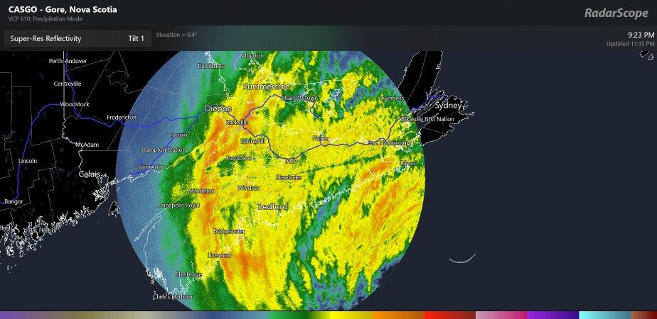
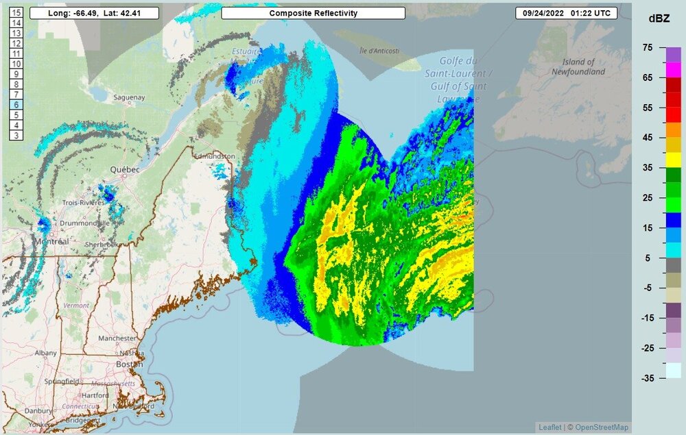
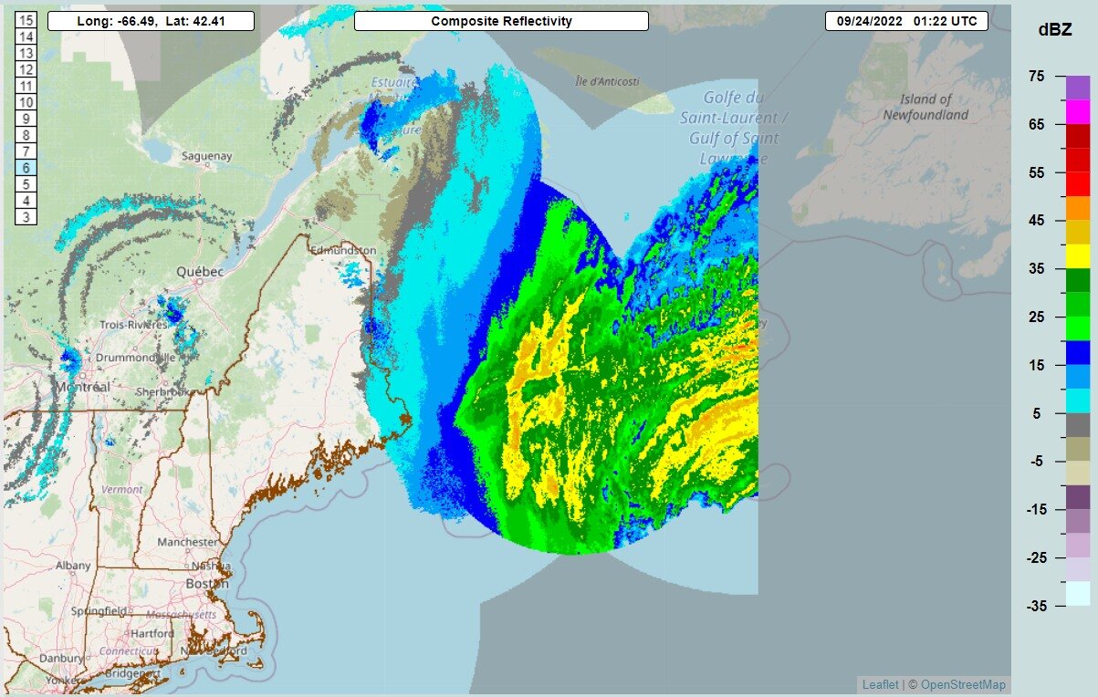
Wonder how much that sting Jet remains but I’m sure that means business. Sable Island gusted to 120mph on that jet?
-
Yep that's not an eyewall anymore, it's more like a frontal boundary now.