

It's Always Sunny
-
Posts
1,947 -
Joined
-
Last visited
Content Type
Profiles
Blogs
Forums
American Weather
Media Demo
Store
Gallery
Everything posted by It's Always Sunny
-
I'm not doubting you because you are King of the Weenies but you generally get higher heights over the NE & somewhat of a block there with warmer temps.
-
You'd want a +PNA and -NAO. +PNA would give you troughing over the Northeast.
-
This is the study I am referring to...when they are both in phase the effect of La Nina is more robust. https://www.nature.com/articles/srep06651 Yeah I agree with -PDO correlating with an increased probability of -PNA but I'm talking more in regards to ENSO. Idk it's really not an important teleconnection when compared to everything else especially due to it's long periodicity.
-
I haven't analyzed the PDO in a while and its affects as of late but for the sake of Northeast cold (and perhaps snow), wouldn't we want to see more of a +PDO signature to mitigate the strength of La Nina? Generally New England does better during weak La Nina/ENSO neutral setups. A -PDO would only enhance La Nina, and possibly make it more central Pacific based which is what we don't want.
-
Read your recent blog. Great information. Added it to my site. Thanks!
-
All things considered I think the Northeast (and even down here in TX) is in for an eventful winter. I've seen more signs pointing to one than not.
-
You can't realistically take those active periods where we got dumped on then add them all up and be like, "that's the ceiling". Winters in New England, especially eastern MA don't work like that. Even in the "highly active" winters, there is a lot of ebb and flow. That's like saying a baseball player who one season mashes 40 HRs before the All-Star break then only hits 15 the second half. And then the next season he hits 15 HRs before the All-Star break then hits 30 after. His ceiling wouldn't be 70 HRs. It's not realistic.
-
Maybe Blue Hill, but that's about it. I think the ceiling can realistically only be slightly above the max ever recorded which I think was 108" or something like that.
-
Just for my own benefit what are your sources? I'm interested in reading more about it/analyzing it closer via composite plots if you have those.
-

Southern Plains Winter 2021-2022
It's Always Sunny replied to Iceresistance's topic in Central/Western States
Generally when you have a SSWE a -NAO/-AO results from it. I definitely think we could see some anomalous cold work its way into N TX again this winter. Chances are it won't be as extreme but I think some record setting days are possible. I actually just wrote up a blog highlighting my thoughts: https://weatherchest.weebly.com/home/archives/09-2021 -
September Discussion Thread: Bring the frost; kill the bugs.
It's Always Sunny replied to moneypitmike's topic in New England
Next week ftw and it's when I'm back in town. I bring fall to all. -
September Discussion Thread: Bring the frost; kill the bugs.
It's Always Sunny replied to moneypitmike's topic in New England
Came across this time-lapse of the current valley fog/stratus fractus in Pemi Valley, NH (near Plymouth). Notice the chaotic motion of the fog/clouds; it's pretty cool.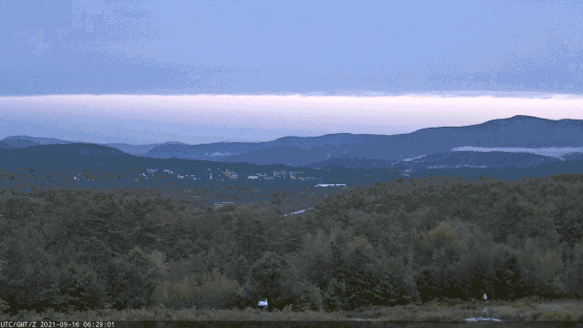
-
Southern Plains Winter 2021-2022
It's Always Sunny replied to Iceresistance's topic in Central/Western States
IOD looks like it will be neutral to negative this winter which constructively interferes with the MJO which is good for amplifying the jet. -
Southern Plains Winter 2021-2022
It's Always Sunny replied to Iceresistance's topic in Central/Western States
Antecedent Gulf hurricanes lol -
Southern Plains Winter 2021-2022
It's Always Sunny replied to Iceresistance's topic in Central/Western States
Those links aren't working for me. -
Southern Plains Winter 2021-2022
It's Always Sunny replied to Iceresistance's topic in Central/Western States
That's a very strange analog lol. I'm not discounting your findings and this may come off as ignorant but I just find it hard to believe tropical systems in the Gulf are correlated with wintertime cold snaps. If anything, it seems more like a coincidence to me. To your last point, it could be something with the MJO/ATL subtropical high orientation though. I honestly haven't looked. My focus usually lies more on the happenings in the upper latitudes & stratosphere when it comes to predicting cold for the south but the atmosphere certainly works in strange ways. -
Southern Plains Winter 2021-2022
It's Always Sunny replied to Iceresistance's topic in Central/Western States
I'm with ya I think this winter has the potential to bring some memorable events despite La Nina. Am I fully confident on that? Not at all but early prospects imply it's a possibility. Recent NMME plot for DJF shows cold anomalies over Alaska. I made a post on twitter but with the right synoptic setup, SSW or strato stretching event we could see some of that cold spill south into the Plains. That's not to mention SEAS5 forecast showing potential precursors to a strato stretching event, which based on a recent study have been increasing over the years. Stretching events are known to help usher that anomalous cold further south (similar to the Big Freeze in February). Personally I don't put a lot of credence in La Nina for here. You can have a warm winter overall but it just takes the right setup to get a cold snap here. -
September Discussion Thread: Bring the frost; kill the bugs.
It's Always Sunny replied to moneypitmike's topic in New England
For those that don't understand anomaly maps: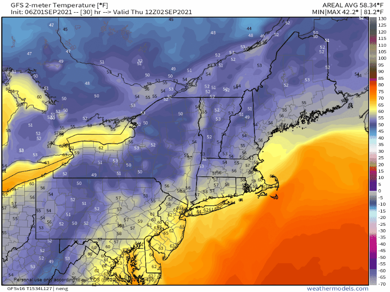
-
September Discussion Thread: Bring the frost; kill the bugs.
It's Always Sunny replied to moneypitmike's topic in New England
Fall wasting no time. Widespread lows in the 40's & 50's.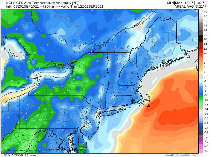
-
Idk if "hype" is the right word but I totally get what you mean; some news outlets began covering this storm even before it was a TD. Public awareness was communicated very early. Not a bad thing but I don't recall a storm garnering this much attention so early in development.
-
Yeah totally agree.
-
Transient outer rainbands probably will but Ida will be well west of TPA, even if it does tick more east.
-
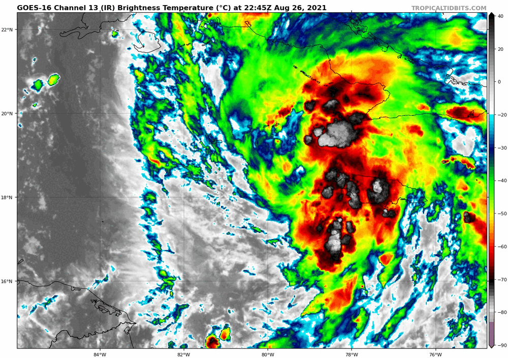
Satellite imagery showing convection blossoming nicely downshear (east side of storm) but still some westerly shear imposing on Ida, with even some pesky dry air lingering to the west associated with the eroding TUTT. DMAX should overcome most of this but I'm interested to see how shear impacts all this overnight as it becomes more southerly.
-
Central/Western Medium-Long Range Discussion
It's Always Sunny replied to andyhb's topic in Central/Western States
Here is a table I created highlighting the differences between our new, current normals and 1981-2010. Low temperatures increased the most which was interesting. Here is the table highlighting key precip differences. Our "wet season" is actually drier than the old normals, with 7/12 extreme precip events occurring in the past 30 years alone (not shown). -
Yeah I checked their site the other day to see how much rain they got (assuming it was record setting) and couldn't find anything. It's too bad especially since these facilities have the equipment but no data logger (at least available to the public).


