It's Always Sunny
-
Posts
1,947 -
Joined
-
Last visited
Content Type
Profiles
Blogs
Forums
American Weather
Media Demo
Store
Gallery
Everything posted by It's Always Sunny
-
NMME generally does pretty good. Looking back to May it's done a rather stellar job for most of the country without getting into specifics.
-
Something quick I threw together. Just keep in mind this focuses mainly on the QBO as a stand-alone along with possible ENSO influence. I haven’t yet sifted through the bulk of the teleconnection indices/models I usually refer to for a seasonal outlook. Time allowing I’ll try and put something together. https://baystatewx.blogspot.com/2022/08/qbo-and-its-potential-implications-on.html?spref=tw
-

Texas/Oklahoma Discussion & Obs Thread 2022
It's Always Sunny replied to It's Always Sunny's topic in Central/Western States
Wow models blew this one. Displayed are 00Z 3km-NAM & 06Z TTU WRF. Couple HRW models had no convection in S TX either. HRW FV3 & GFS were wayyyy too far north with convection. 18Z guidance yesterday was even better than these two models shown.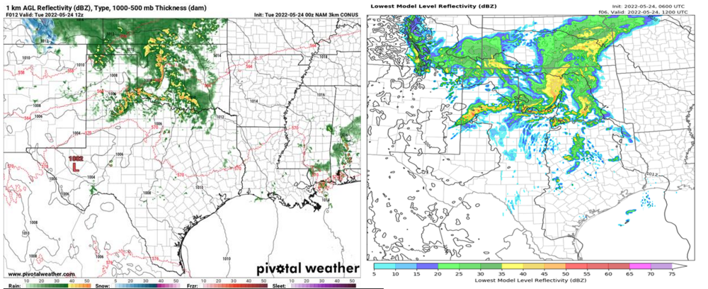

-
Texas/Oklahoma Discussion & Obs Thread 2022
It's Always Sunny replied to It's Always Sunny's topic in Central/Western States
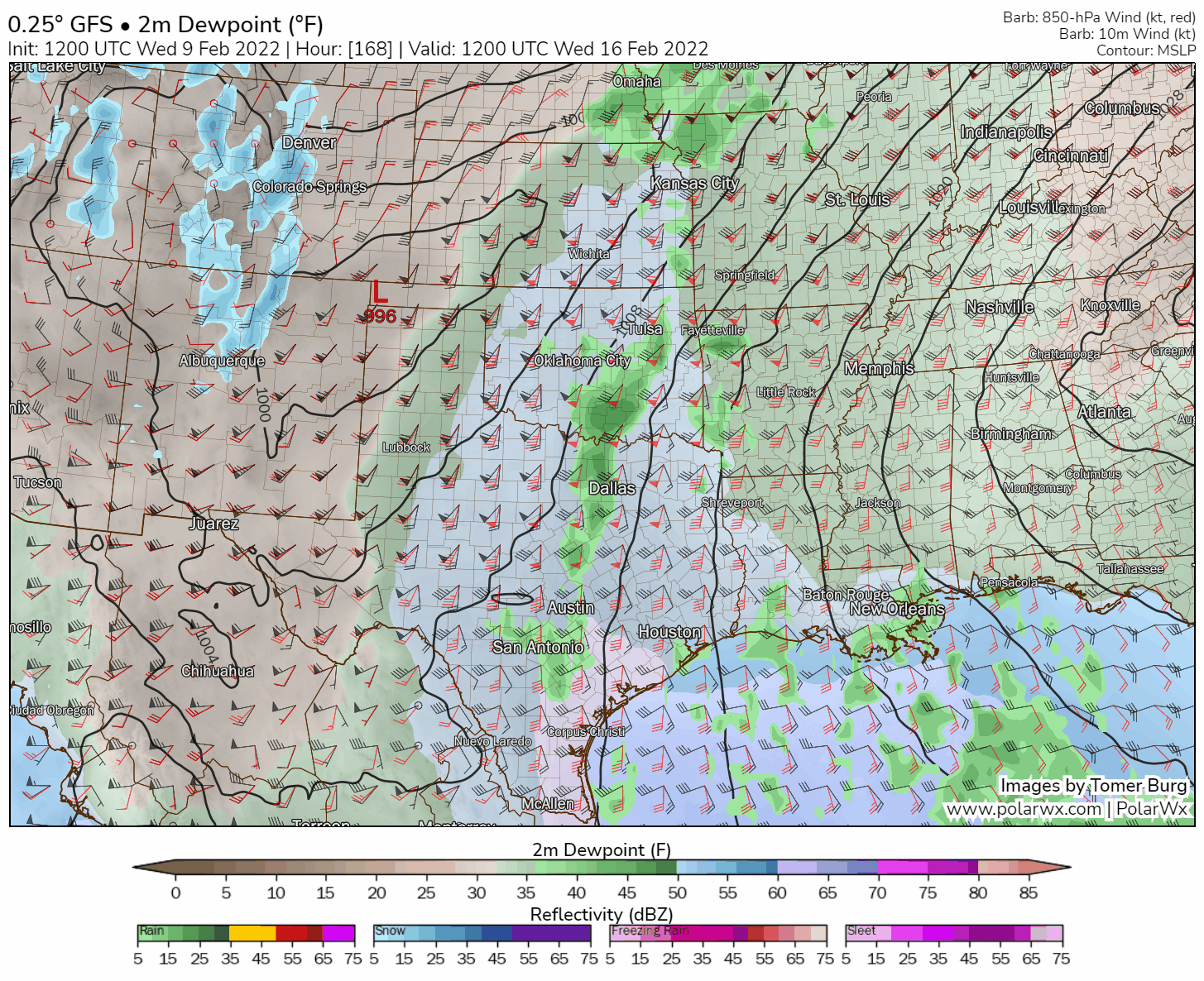
There is a lot of mid-upper level dry air which has been modeled the entire time but it's saturated high enough to precipitate. From a weather geek standpoint it's not often you see a bone dry mid-upper level sounding with a low level stratiform deck that begins as liquid water and reaches the surface as sleet or freezing rain. It's more frequent to see precipitation begin as snow, melt and refreeze. Thankfully this stratiform type of setup allows everything to be light with low QPF amounts. However, to get sleet we will need some ice crystals which may be hard to attain given the static look to soundings. You would need colder temperatures in the boundary layer and likely slightly better lift than modeled to get the ice crystals necessary for that to materialize, otherwise we're looking at FZRA or FZDZ. -
Texas/Oklahoma Discussion & Obs Thread 2022
It's Always Sunny replied to It's Always Sunny's topic in Central/Western States
Yeah the ECMWF hasn't done well with these shallow, cold air masses which explains why they are leaning colder. NAM could be too cold but I think leaning that way is good at the current lead time. -
Feb 13-14 snowstorm/nor’easter potential
It's Always Sunny replied to George001's topic in New England
2-4" for BOS looking more reasonable based off 00Z suite. -
Next week's severe weather potential looking good per dry line setup in TX/OK. Low level moisture, CAPE (not shown), kinematics all in place. Not a bad look at all albeit a week out.

-
Still lots of asymmetric spread but for snow weenies good to see it on the W/NW side. Obviously too far west isn't good but any sign that keeps this thing closer to the coast rather than OTS is a win for the time being.
-
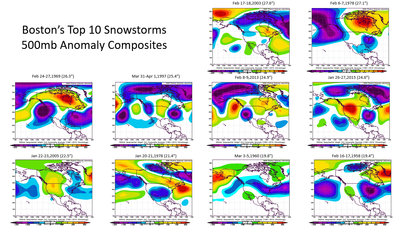
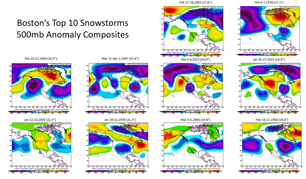
Had some spare time to put this together. Current modeled output resembles January 26-27, 2015 blizzard. Surprisingly most of these events occurred when the NAO was neutral-positive.
-
December 2021 Obs/Disco...Dreaming of a White-Weenie Xmas
It's Always Sunny replied to 40/70 Benchmark's topic in New England
Highs in the 40s isn't cold enough for you? . DFW may get close to 80F I'm loving every bit of it -
Southern Plains Winter 2021-2022
It's Always Sunny replied to Iceresistance's topic in Central/Western States
I think we're close to a lock to break the latest freeze record which is Jan 4th (1972). -
Meh on this potential IVT. Sniffing snizzle.
-
11/26-11/27 Rain Ending as Snow Obs/Disco
It's Always Sunny replied to 40/70 Benchmark's topic in New England
Manch Vegas mixing now -
Oh I'm talking about tomorrow night. I was like Will's a smart dude but uh it looks very similar lol.
-
12Z had a similar look though. 18Z doesn't look much different if we're talking h5
-
Just saw this after I posted...I agree!
-
This thread should be renamed to Nov 26-27 Snow Threat much better chance people see snow tomorrow.
-
You and your ceilings...just like your prediction a couple months ago Boston can get 150+" of snow smh.
-
If anyone east of 95 in MA is expecting more than 1" you'll be disappointed.
-
I think this is currently an underplayed system tomorrow night. Quite a few spots from MHT up through PWM could see between 1-3".
-
Southern Plains Winter 2021-2022
It's Always Sunny replied to Iceresistance's topic in Central/Western States
Yeah 18Z is nice for you. We just end up with our first freeze of the season here. Still fantasyland though... -
Southern Plains Winter 2021-2022
It's Always Sunny replied to Iceresistance's topic in Central/Western States
12Z GFS... -
This is what happens when The Weather Channel (and the media in general) refers to the Polar Vortex so loosely; it creates misconception. They have everyone looking up at 10mb when at 500mb and below is what actually produces most of the time.
-
I haven't read this article but just goes to show how much more there is to learn. Thanks for the link!
-
Ok yeah I get what you're saying but I guess the point I was trying to make was there have been a few months during Dec-Apr where IOD was negative and has had some influence on downstream impacts via enhanced Walker Circulation. Obviously what transpires in the IO will have certain amount of time lag before its influence is felt over the Pacific but like mentioned before I think this is an area of research that can be explored more. IO is such a huge driver of our summer weather I would think there is at least some influence (big or not) it has on winter weather, more than what we currently know. There was some research done back in 2015 I think that correlated summer/fall IOD phase to proceeding ENSO phase with 8-14 month lead time. Results weren't entirely accurate but r-values were sound. It didn't pan out this year when referencing last but I believe the year before it did I would have to go back and look. Just shows how "new" all this is.