It's Always Sunny
-
Posts
1,947 -
Joined
-
Last visited
Content Type
Profiles
Blogs
Forums
American Weather
Media Demo
Store
Gallery
Everything posted by It's Always Sunny
-

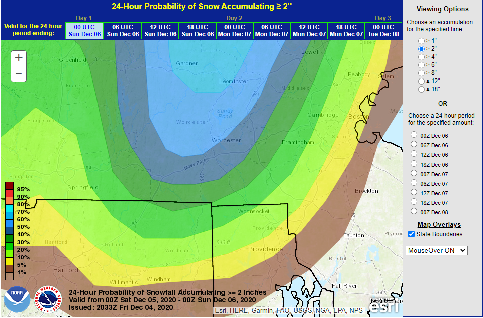
December 5-6, 2020 Storm Observations and Nowcast
It's Always Sunny replied to Baroclinic Zone's topic in New England
Waking up to snow totals this morning . Hoping NWS updates these and we see some increased totals. -
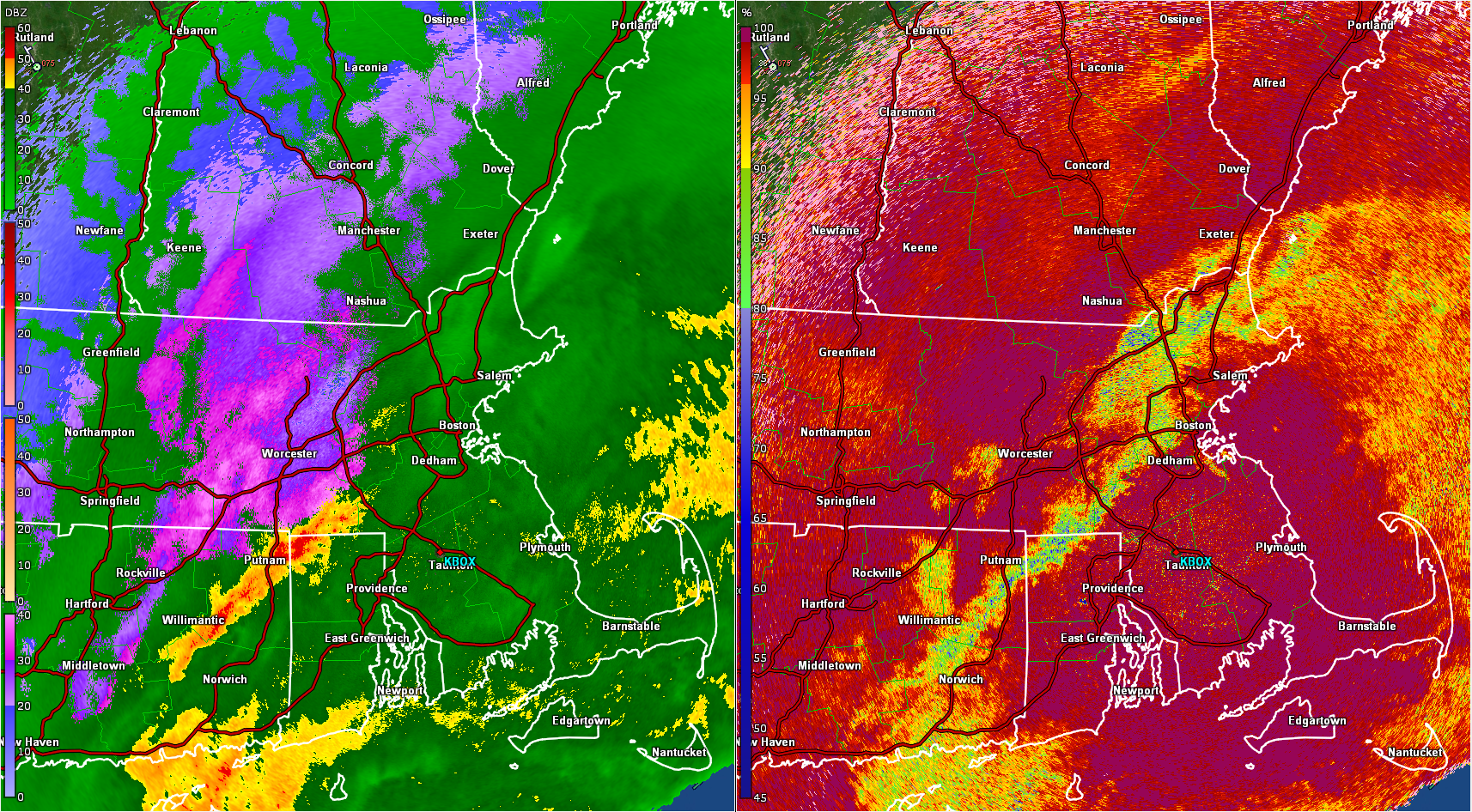
December 5-6, 2020 Storm Observations and Nowcast
It's Always Sunny replied to Baroclinic Zone's topic in New England
Lowell/Lawrence should flip to snow or mix soon according to radar. -
December 5-6, 2020 Storm Observations and Nowcast
It's Always Sunny replied to Baroclinic Zone's topic in New England
KMHT 051726Z 0518/0618 35008KT 1SM -SN BR OVC004 FM052200 33024G33KT 1/2SM SN OVC005 WS020/00050KT FM060400 32020G30KT 2SM -SN OVC010 WS020/00050KT FM060600 32018G26KT 5SM -SN BR OVC025 FM060900 31016G24KT P6SM OVC035 -
December 5-6, 2020 Storm Observations and Nowcast
It's Always Sunny replied to Baroclinic Zone's topic in New England
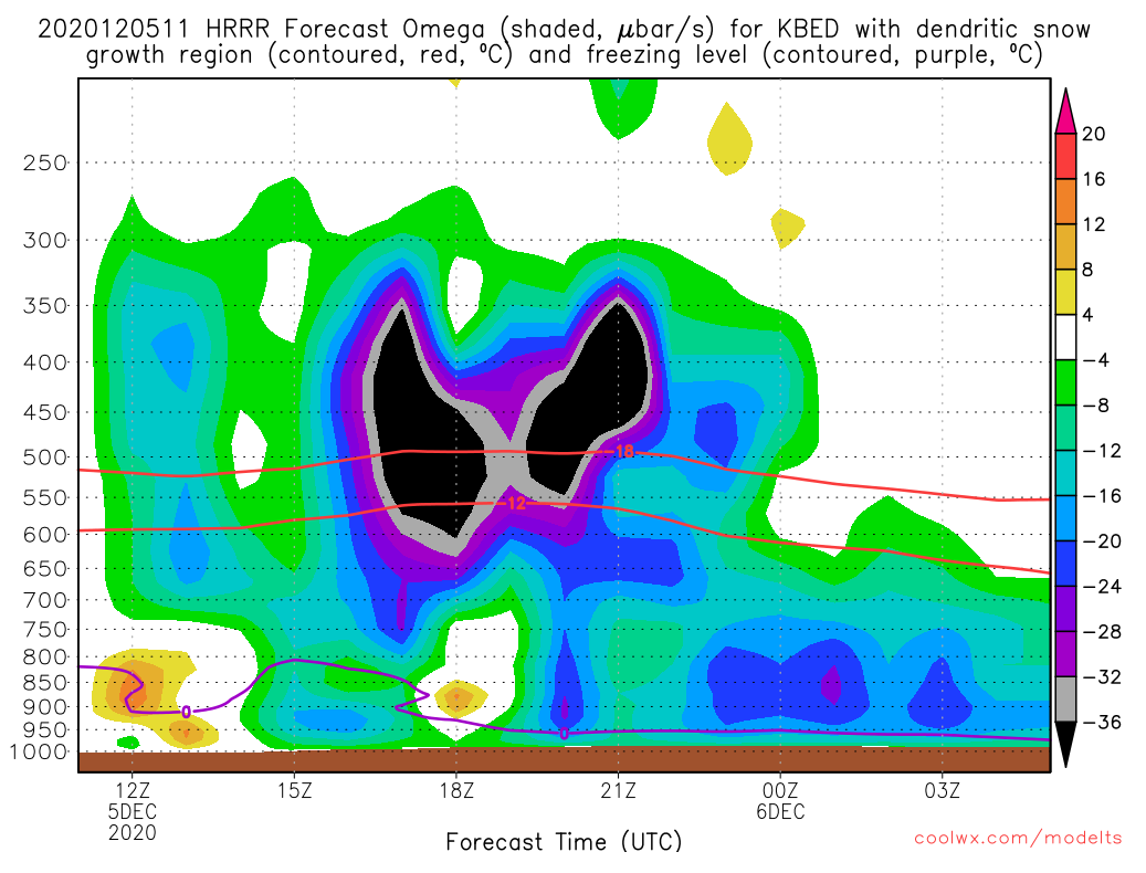
Yeah that's what the HRRR currently has just curious to see if that srn LP/open wave trough tugs that parent low more south and east which would cause BOS to flip earlier than modeled is my guess. Who knows lol. -
December 5-6, 2020 Storm Observations and Nowcast
It's Always Sunny replied to Baroclinic Zone's topic in New England
Thinking out loud, wonder if srn LP keeps this system more south and east than modeled. I would presume this would help E MA and their snow amounts. Open to other input.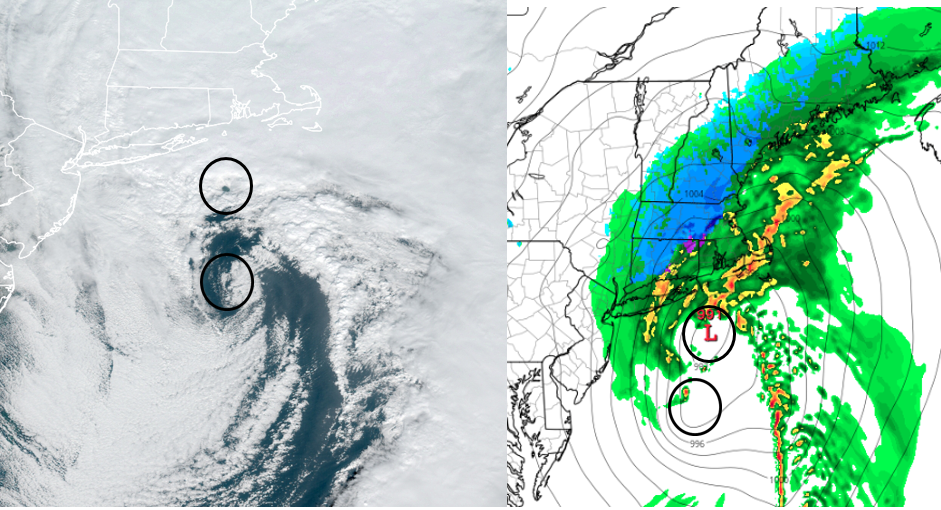
-
December 5-6, 2020 Storm Observations and Nowcast
It's Always Sunny replied to Baroclinic Zone's topic in New England
-
December 5-6, 2020 Storm Observations and Nowcast
It's Always Sunny replied to Baroclinic Zone's topic in New England
Looks like LCI starting to mix. C'mon Plymouth! -
December 5-6, 2020 Storm Observations and Nowcast
It's Always Sunny replied to Baroclinic Zone's topic in New England
Looks like melting later is pivoting NW and encroaching towards 495/north shore so a change over back to rain/mix could be possible soon for cntrl-nrn Middlesex county. -
December 5-6, 2020 Storm Observations and Nowcast
It's Always Sunny replied to Baroclinic Zone's topic in New England
I was on Plymouth during one of my years there. Worst apartment ever lol. -
December 5-6, 2020 Storm Observations and Nowcast
It's Always Sunny replied to Baroclinic Zone's topic in New England
LCI battling -RA with that NE wind while CON snows with N wind crazy what only a few miles can do. -
December 5-6, 2020 Storm Observations and Nowcast
It's Always Sunny replied to Baroclinic Zone's topic in New England
Anyone in Lowell? -
December 5-6, 2020 Storm Observations and Nowcast
It's Always Sunny replied to Baroclinic Zone's topic in New England
Based on the observation posts seems rain/snow line is right along 495. LWM still rain though so seems right around Rt 3/495 intersection westward is mainly a mix/snow. -
December 5-6, 2020 Storm Observations and Nowcast
It's Always Sunny replied to Baroclinic Zone's topic in New England
-SN in Manch. Some TAF -
December 5-6, 2020 Storm Observations and Nowcast
It's Always Sunny replied to Baroclinic Zone's topic in New England
-SN in Nashua, NH -
December 5-6, 2020 Storm Observations and Nowcast
It's Always Sunny replied to Baroclinic Zone's topic in New England
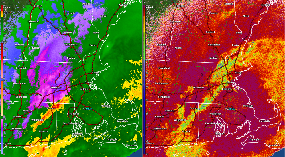
Nice example of bright banding. Melting layer around 1500'.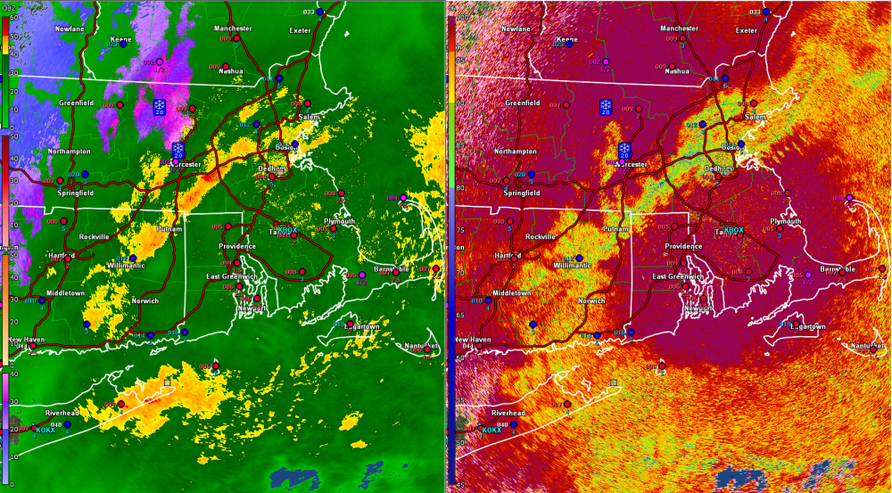
-
Dec 5/6th major coastal/ west Atlantic cyclogenesis ...?
It's Always Sunny replied to Typhoon Tip's topic in New England
Paint it black. 495 & Hills bruiser.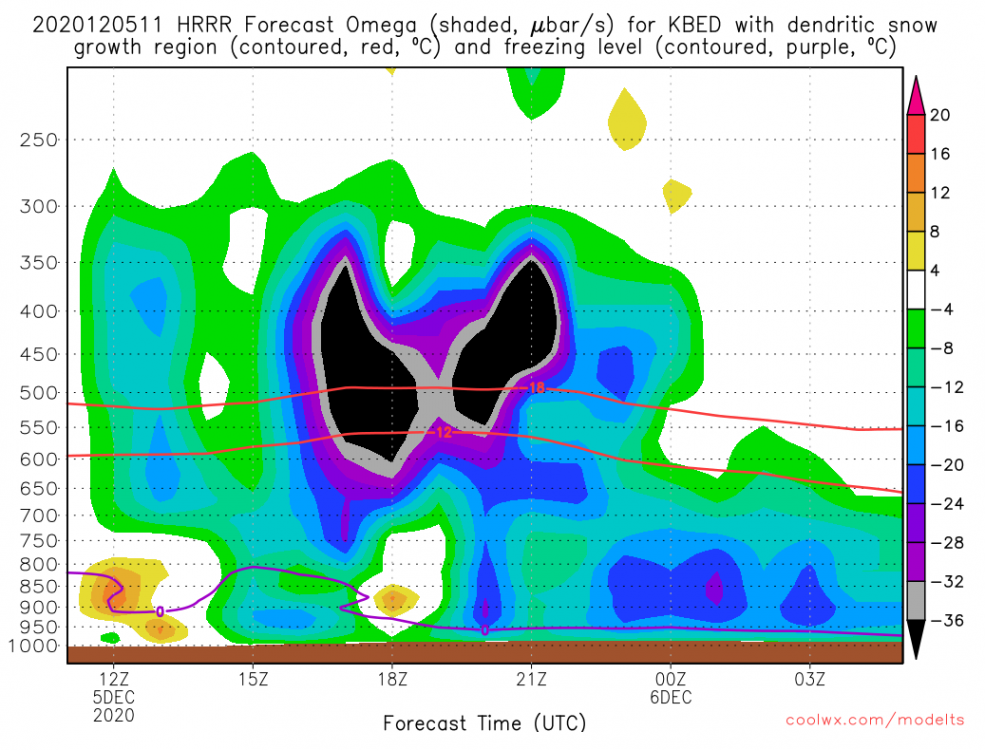
-
Dec 5/6th major coastal/ west Atlantic cyclogenesis ...?
It's Always Sunny replied to Typhoon Tip's topic in New England
Agree, and could (and should imo) even be earlier than that. Most NWS offices don't pay too much attention to TAFs, as evident here. 8-12" in 3 hours...okay you think that NWS lol. -
Dec 5/6th major coastal/ west Atlantic cyclogenesis ...?
It's Always Sunny replied to Typhoon Tip's topic in New England
Da fuk? KMHT 051132Z 0512/0612 VRB04KT P6SM -RA FEW024 OVC029 FM051400 36011KT 4SM -RA OVC005 FM052200 35016G28KT 4SM +RA OVC004 WS020/00050KT FM060300 32016G31KT 1/2SM SN OVC015 FM060600 31016G30KT P6SM OVC025 -
Dec 5/6th major coastal/ west Atlantic cyclogenesis ...?
It's Always Sunny replied to Typhoon Tip's topic in New England
Lol just a bit. I've been here for over 5 yrs and haven't had more than a coating in the metroplex, thankfully (considering nobody knows how to handle winter precip here) nor do they have the resources to treat the roads. Dreading my first freezing rain event here though between the power outages and poor road conditions in the event I have to drive into work. Last one was in March 2015 right before I got here so DFW is due, just a matter of when. -
Dec 5/6th major coastal/ west Atlantic cyclogenesis ...?
It's Always Sunny replied to Typhoon Tip's topic in New England
I'm glad this event will likely pan out for most I wasn't too optimistic on it a few days ago where it appeared like it would cut but it seems that the LP slowed and phased with nrn stream when it was over TN Valley putting it on a favorable track for most. It appeared at first the LP needed to dig further south when it was over TX to get any sort of chance but looks like nrn stream came to the rescue and took it under its wing. Hoping the GFS resolves itself for ern MA to make this an all inclusive event for everyone. -
Dec 5/6th major coastal/ west Atlantic cyclogenesis ...?
It's Always Sunny replied to Typhoon Tip's topic in New England
The LP is deepening more than earlier runs have suggested which could be one of the reasons it has slowed down its progressive motion. It's also slightly further south, a bit more removed from "stronger" upper level flow. Could be a myriad of different reasons but those are two that have stuck out to me. -
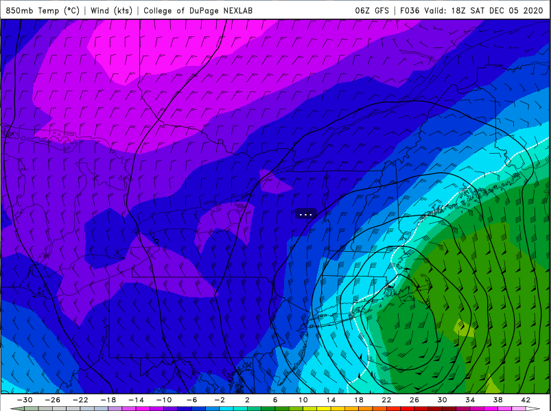
Dec 5/6th major coastal/ west Atlantic cyclogenesis ...?
It's Always Sunny replied to Typhoon Tip's topic in New England
Pretty much only a 25 mile difference of 0C isotherm is what is keeping the GFS from being in agreement with the rest of the models. Definitely think it is resolvable.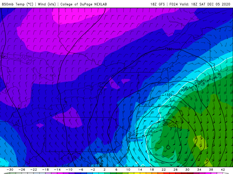
-
Dec 5/6th major coastal/ west Atlantic cyclogenesis ...?
It's Always Sunny replied to Typhoon Tip's topic in New England
21Z WSI RPM improved for north shore: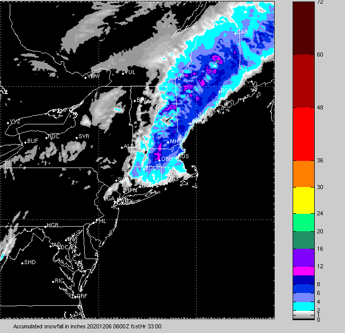
-
Dec 5/6th major coastal/ west Atlantic cyclogenesis ...?
It's Always Sunny replied to Typhoon Tip's topic in New England
TROWAL showing up well over BDL at 18Z between 650-700mb with easterly wind and kink in isotherms. CCB just below it with more NE'rly winds.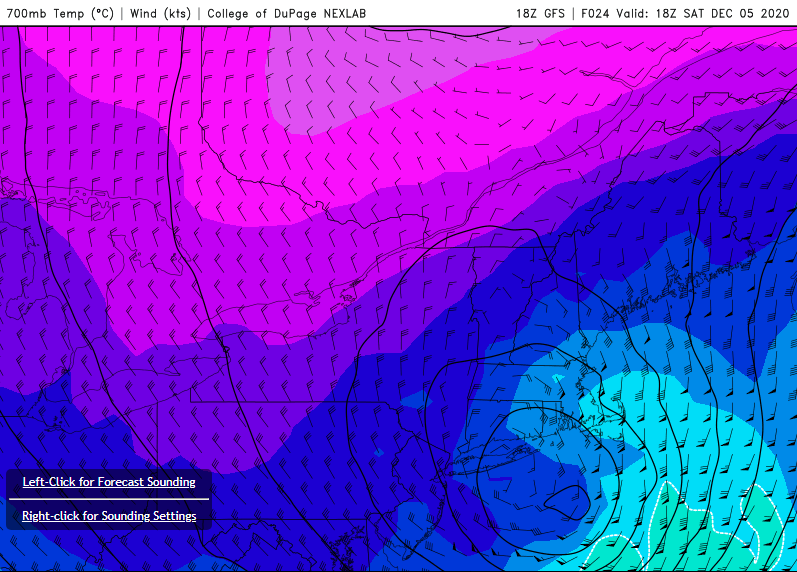
-
Dec 5/6th major coastal/ west Atlantic cyclogenesis ...?
It's Always Sunny replied to Typhoon Tip's topic in New England
Anyone know what model this is generated from? It poo-poos ern MA similar to GFS. EDIT: Idk why I said nrn CT I think I'm looking at too many things.