

It's Always Sunny
-
Posts
1,947 -
Joined
-
Last visited
Content Type
Profiles
Blogs
Forums
American Weather
Media Demo
Store
Gallery
Everything posted by It's Always Sunny
-
 Absolute torch today. Wx station at home is reading 90F with other wx stations around reading between 88-90F so it's legit! Should set the stage for some good thunderstorms tomorrow night.
 -
Some severe potential coming together for DFW early evening tomorrow along nice surface convergence boundary. Cap appears to be in place but around 21Z models erode it. Hodos have a weak and subtle curve but may generate a couple isolated supercells. SPC has marginal out so it definitely bears some watching. Risk overall is low but certainly bears watching.
-
Yeah I agree to not put too much stock into ops models this far out but ensembles do favor unsettled weather around here first week of March so we'll see how it verifies. Ensembles mid to late March don't look quite as favorable (at least for now).
-
Had nothing significant here near DFW airport other than some wintry mix that ended up melting once it hit the surface but I think models did a fairly good job depicting the northwest to southeast temperature gradient.
-
I agree. These fronts are always so shallow which keeps me leery of the entire column cooling enough to produce wintry precip.
-
The cold air will obviously be there at the surface but I'm more focused on the temperatures aloft which will be the determining factor. GFS nukes lower levels (resulting in cold rain/freezing rain) while NAM and Euro run colder (likely sleet/snow/patchy freezing rain).
-
Lots of varying solutions with NAM being the coldest thus far. It's still too early to tell if Dallas will be a wintry mix or cold rain.
-
Ratios were crap though doesn't matter if it's freezing at the surface. 5:1 ratio amounts will give you that.
-
ABQ ended up reporting 0.7" snow (midnight to midnight) so it matches your expectations. I don't know what the liquid equivalent was with that final total but as you know ABQ gets crap ratios frequently due to their climate/geographic location (snow shadowing).
-
-SN in ABQ. Our official forecast is up to 1" but if it stays just cold enough I think 1-3" is certainly possible.Those temperatures around 750mb are going to be the determining factor.
-
Absolutely torching in Texas today. 81F at my house which is nearly 25F above normal. DFW may tie or break its daily record of 80F. It's at 79F now with skies clearing.
-
That was just before I moved here I knew it was sometime around then, and it was snow/sleet, not freezing rain. Those two pictures in that link are hilarious. Typical TX weather lol.
-
The low level cold will be locked in but it is whether we have the moisture to allow for some frozen precipitation to materialize. Like cheese said it's been some time since we've had something like this here. We're due lol. Last notable winter precipitation event in DFW area was February 2015 I believe with the FZRA.
-
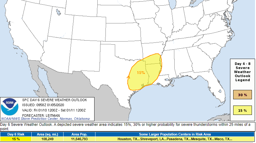
Bit of a west tick puts Dallas in the 15% risk now:
-
Analogs suggest a lower MS Valley outbreak as of right now.
-
Models trended slightly east overnight which doesn't surprise me. DFW was on the western fringe to begin with but still plenty of time for models to change:
-
Given the pattern this month could see a couple slight risk days here in N TX and parts of the SE as well.
-
Probably for the panhandle everywhere else will be rain.
-
2019 ENSO
It's Always Sunny replied to AfewUniversesBelowNormal's topic in Weather Forecasting and Discussion
I like what it is doing as well and agree with it to some degree, considering the continuous push of warm water east however is this model taking into assumption more warm water pushing east from Maritimes in conjunction with a modeled weakening of trade winds? -
There was some considerable low level dry air associated with this anafront which gobbled up a lot of what little QPF there was to begin with. That, along with a more pronounced warm nose than modeled was the nail in the coffin for any wishful snow chances here.
-
2019 ENSO
It's Always Sunny replied to AfewUniversesBelowNormal's topic in Weather Forecasting and Discussion
You think that developing EWB over Nino 4 will put a bit of a damper on the anomalous warm water pushing east? I still think it'll be enough to warm Nino 3.4 but maybe not quite as much as we think? I still think CFS forecast may be underdoing it a bit but that's just my opinion. -
NW and W of the Metroplex I think it's certainly possible but as you get further east I think that risk drops off considerably. 12Z GFS give Stephenville and Granbury a brief shot at some wet snow overnight tonight but I wouldn't expect anything more than a coating. Western Fort Worth I think even has a slim chance to see some mixing for a brief window.
-
Meh. If that happens precip will likely get shunted further south so it wouldn't matter. I think even if your scenario panned out lower levels will still be too warm unless it miraculously wet-bulbs to 0C.
-
2019 ENSO
It's Always Sunny replied to AfewUniversesBelowNormal's topic in Weather Forecasting and Discussion
Hey @raindancewx a bit off topic but does La Nina generally correlate with an increased -EPO frequency since La Nina's usually result in the jet stream "buckling" over the Gulf of Alaska? Would the opposite be true for El Ninos (+EPO)? -
You mean zero chance of snow north of I-20? Going to be all rain here...

