Radtechwxman
-
Posts
2,481 -
Joined
-
Last visited
Content Type
Profiles
Blogs
Forums
American Weather
Media Demo
Store
Gallery
Everything posted by Radtechwxman
-
888mb was just unrealistic. All the hurricane models were way overdone imo. Probably a more realistic portrayal. But like I said before, can't really trust any intensity guidance right now. Need our system to really develop first.
-
Yeah I'm really curious if we will see that cutoff and Helene Fujiwara with each other or if Helene will just deflect ne with little to no interaction.
-
I'm not trusting any model intensity until we have a developed LLC and this system starts organizing. Models are struggling with intensity because the system hasn't got established yet so they're essentially grasping at straws that don't exist.
-
Use the global OPs for pattern and track, less so for intensity. The ECMWF is excellent for overall track guidance. Obviously, if the globals are significantly intensifying a system, it's worth noting. But it is better to use the TC models for intensity once we have an established tropical cyclone. I say this because TC models can way overdo the intensity on an invest that has yet to form a proper vorticity maximum. That's a bit of a tangent, so to just be clear, focus less on the global OPs for exact intensity and more for track of system. I'd stress even further that the ensembles means are much better at determining overall track three-to-four days out, especially prior to TCG, as it's still unclear where exactly that will occur for initial origin of track. Great analysis. Kind of my thought. Though shockingly GFS has overall been on board with a high end outcome. But like you said not really trusting intensity outcomes till we have a defined vorticity maximum and formation of a TD or TS. So far the gyre seems to be struggling to focus an area of concise vorticity. If this takes a while to organize, higher end outcomes are less likely to be realized.
-
0z euro remaining very tame with little to no deepening up until landfall. What is its track record with hurricanes?
-
Satellite remarkably improving now. Much more symmetrical looking and nice CDO expanding and cooling. Might see this overachieve a bit in short term before it levels off or weakens near landfall as that shear/wind shear catches Francine.
-
Looks like we are getting decent pressure drops again. Probably will see a hurricane later this morning or early afternoon.

-
Deep burst of convection now wrapping into the LLC. Will see if it maintains. If so strengthening should commence again. I do agree with 40/70 Benchmark and ceiling is likely lower now with this one unless something really crazy happens today.
-
Totally agree. Ernesto was never able to truly take off due to its inner core plagued by dry air despite favorable shear and SST's.
-
That really has got into the core and majorly disrupted it. This could definitely hold the ceiling back till landfall if the dry air can't be mixed out.
-
Agreed. But odd dry air issues weren't forecast till closer till landfall. Last nhc discussion even talked about favorable moist environment for Francine. Seems kind of unexpected at least this early.
-
Looking at water vapor and satellite some dry air entrainment definitely got into core. Curious if this will have major impacts on intensification or if the high octane ocean will help compensate.
-
8pm advisory brought winds up to 70mph but pressure stayed same. You don't see that happen often.
-
 Satellite has really improved last few scans. Beryl has been a remarkable hurricane. Inner core has really reorganized again.
 -
I think would have been different story if they had flown a mission hours ago. I think they might have just missed the peak of Beryl. Regardless still an absolute monster for July.
-
It's too bad hurricane hunters won't be in there till later because I think Beryl is probably peaking now and would love to see data. Have a feeling by time they get there we will be past the peak. Wouldn't be shocked if Beryl is cat 5 now.
-
May 16 - June 4, 2024 Severe Weather
Radtechwxman replied to Quincy's topic in Central/Western States
This thread is dead for such a potential significant day tomorrow -
May 16 - June 4, 2024 Severe Weather
Radtechwxman replied to Quincy's topic in Central/Western States
Man models not wanting to pop anything Sat. Very perplexed by this. -
Really unsure where to target today. Part of me wants to get on the storms near low before they line out but afraid they may get undercut. Part of me is afraid something will go east along a remnant boundary and shear vector orientation and hodograph curvature is better east. Tricky forecast today
-
2024 Short/Medium Range Severe Weather Discussion
Radtechwxman replied to Chicago Storm's topic in Lakes/Ohio Valley
I agree. But the 30% area will likely need one from evolving qlcs. And hatched area will be needed further west for tornado threat near sfc low and large hail threat with initial discrete supercells. -
2024 Short/Medium Range Severe Weather Discussion
Radtechwxman replied to Chicago Storm's topic in Lakes/Ohio Valley
Same. Enhanced days are significant weather days so going to have a hatched area definitely for wind and probably tornadoes. Makes 0 sense. -
2024 Short/Medium Range Severe Weather Discussion
Radtechwxman replied to Chicago Storm's topic in Lakes/Ohio Valley
I do agree it is a very impressive shortwave and definitely bares some resemblance to 4-26-24. However, what are your thoughts on shear vector orientation to initiating boundary? Seemed like there was a less than 45 degree component esp to west but more orthogonal to the east. If you get a prefrontal trough could be a bigger tornado threat but wondering if storms fire off DL/pacific front if they will be more of a mixed mode of lines and embedded sups. -
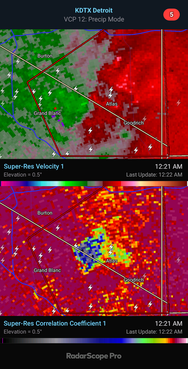
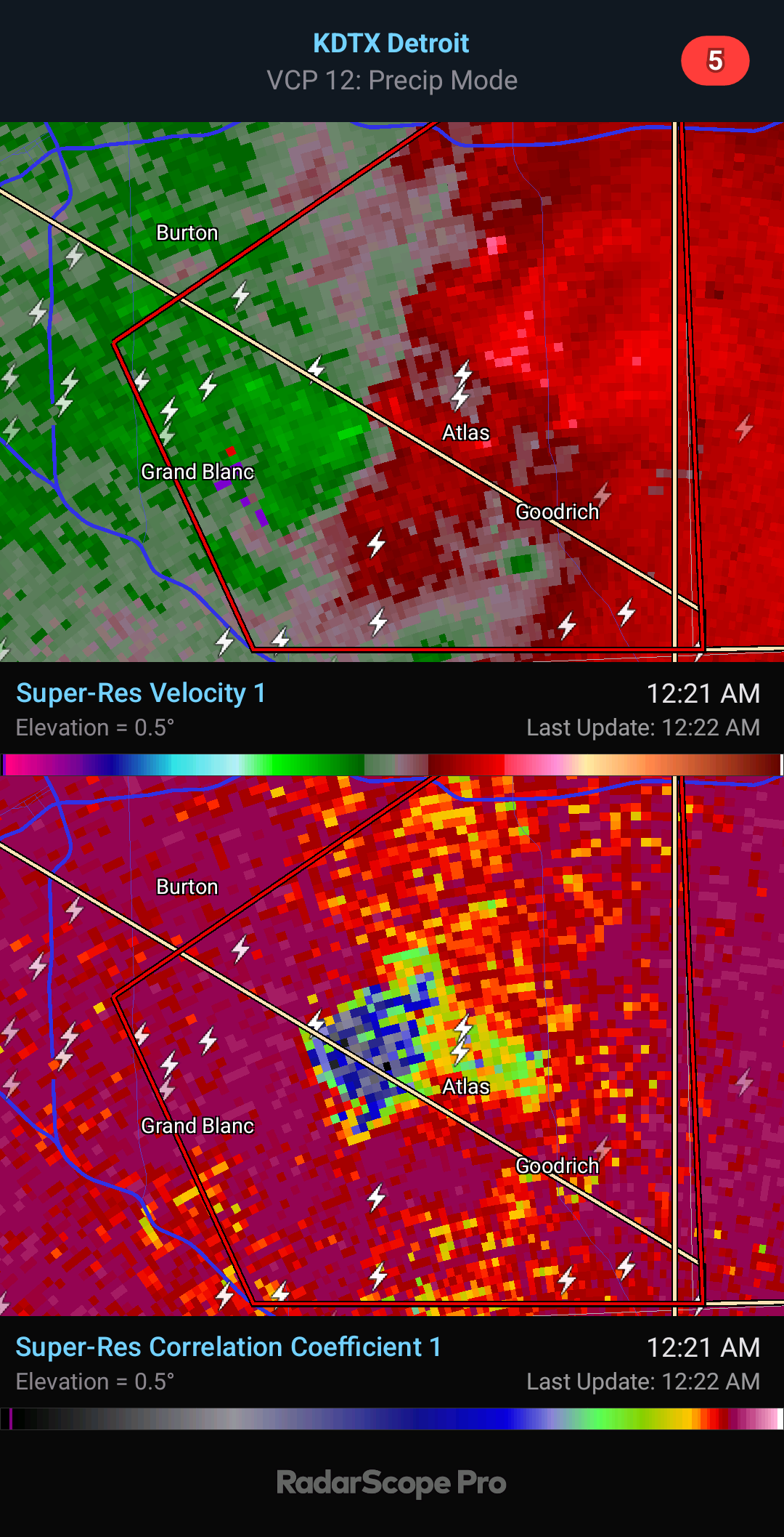
That's what I was thinking. Tight couplet. Thanks
-
Do you know which storm that's on?
-
Huge debris fallout. Wow. That likely inflicted a good amount of damage in town.