donsutherland1
-
Posts
22,981 -
Joined
Content Type
Profiles
Blogs
Forums
American Weather
Media Demo
Store
Gallery
Everything posted by donsutherland1
-
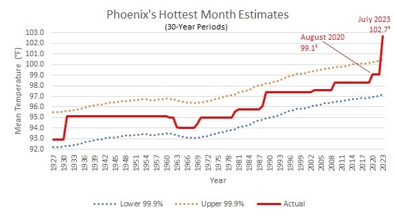
In Phoenix, July 2023 was so hit that it broke out of the 99.9% confidence interval for hottest month relative to the 30-year moving average of summer temperatures. This shows how extraordinary the month was. It could imply that the record will stand for some time, monthly extremes are growing faster than summer temperatures are rising, and/or climatic variability is increasing in the warming climate.
-
A line of strong to perhaps severe thunderstorms will push across the region this evening. Drier weather will follow tomorrow and continue through midweek. Near-term heat is unlikely. The latest ECMWF weeklies continue to show no notable heat through at least the first half of August. The U.S. Southwest remains in the midst of unseasonable heat. The intense heat will slowly fade this week. Today, Laredo reached an August monthly record-tying 111°. El Paso reached 109°, its third consecutive day above the pre-2023 August monthly record of 108°. Del Rio (109°), San Angelo (109°), and San Antonio (105°) all set records. New Orleans reached 100° for a record 3rd consecutive day. Baton Rouge reached 100° for a record 10th consecutive day. The ENSO Region 1+2 anomaly was +3.4°C and the Region 3.4 anomaly was +1.1°C for the week centered around August 2. For the past six weeks, the ENSO Region 1+2 anomaly has averaged +3.25°C and the ENSO Region 3.4 anomaly has averaged +1.07°C. El Niño conditions have developed and will likely continue to strengthen through at least the summer. The probability of an East-based El Niño event has increased. The SOI was -27.07 today. The preliminary Arctic Oscillation (AO) was -1.254 today. On August 5 the MJO was in Phase 1 at an amplitude of 1.646 (RMM). The August 4-adjusted amplitude was 1.506 (RMM). Based on sensitivity analysis applied to the latest guidance, there is an implied 57% probability that New York City will have a cooler than normal August (1991-2020 normal). August will likely finish with a mean temperature near 75.4° (0.7° below normal).
-
Showers and thundershowers are likely tonight and again tomorrow. Tomorrow's thunderstorms could be strong to severe, especially south and west of New York City. Flash flooding is possible where the heaviest thunderstorms develop. Drier weather will follow and continue through midweek. Near-term heat is unlikely. The latest ECMWF weeklies continue to show no notable heat through at least the first half of August. The U.S. Southwest remains in the midst of unseasonable heat. The intense heat will slowly fade this week, but additional locations could reach or break their August monthly records. Phoenix topped out at a record-tying 114°. El Paso (112°) and Del Rio (110°) set August monthly record high temperatures. Baton Rouge reached 100° for the 9th consecutive day. That broke the record of 8 consecutive days from August 19-26, 1921. Brownsville (8 consecutive days) and Lafayette (8 consecutive days) also set new marks for most consecutive 100° days. New Orleans reached 100° for a record-tying second consecutive day. The ENSO Region 1+2 anomaly was +3.0°C and the Region 3.4 anomaly was +1.2°C for the week centered around July 26. For the past six weeks, the ENSO Region 1+2 anomaly has averaged +3.17°C and the ENSO Region 3.4 anomaly has averaged +1.05°C. El Niño conditions have developed and will likely continue to strengthen through at least the summer. The probability of an East-based El Niño event has increased. The SOI was -24.16 today. The preliminary Arctic Oscillation (AO) was -1.296 today. On August 4 the MJO was in Phase 1 at an amplitude of 1.503 (RMM). The August 3-adjusted amplitude was 1.158 (RMM).
-
Tomorrow will be another fair and pleasantly warm day. Highs will mainly reach the lower and middle 80s. Showers and thundershowers are possible on Monday. Near-term heat is unlikely. The latest ECMWF weeklies continue to show no notable heat through at least the first half of August. The U.S. Southwest is again in the midst of unseasonable heat. Phoenix reached 116° today (old record: 115°, 2019). Albuquerque, Deming, El Paso, and Truth or Consequences all reached or exceeded their August monthly records. The intense heat will slowly fade next week, but additional locations could reach or break their August monthly records. Baton Rouge reached 100° for the 8th consecutive day. That tied the record of 8 consecutive days from August 19-26, 1921. That record will likely be broken on Sunday. The ENSO Region 1+2 anomaly was +3.0°C and the Region 3.4 anomaly was +1.2°C for the week centered around July 26. For the past six weeks, the ENSO Region 1+2 anomaly has averaged +3.17°C and the ENSO Region 3.4 anomaly has averaged +1.05°C. El Niño conditions have developed and will likely continue to strengthen through at least the summer. The probability of an East-based El Niño event has increased. The SOI was -21.61 today. The preliminary Arctic Oscillation (AO) was -0.819 today. On August 3 the MJO was in Phase 1 at an amplitude of 1.161 (RMM). The August 2-adjusted amplitude was 0.951 (RMM).
-
The weekend will feature fair and pleasantly warm readings. Highs will mainly reach the lower and middle 80s. Showers and thundershowers are possible on Monday. No significant hot weather appears likely through the first 10 days of August. In fact, the latest ECMWF weeklies show no notable heat through at least the first half of August. The U.S. Southwest is again in the midst of unseasonable heat. Phoenix reached 115° today Cities such as Del Rio, El Paso, Phoenix, and Tucson could approach or reach their August high temperature records before the heat fades. Louisiana is also roasting. Baton Rouge reached 100° for the 7th consecutive day. That is tied for the second longest such streak. The record of 8 consecutive days from August 19-26, 1921 will likely be tied tomorrow and broken on Sunday. The ENSO Region 1+2 anomaly was +3.0°C and the Region 3.4 anomaly was +1.2°C for the week centered around July 26. For the past six weeks, the ENSO Region 1+2 anomaly has averaged +3.17°C and the ENSO Region 3.4 anomaly has averaged +1.05°C. El Niño conditions have developed and will likely continue to strengthen through at least the summer. The probability of an East-based El Niño event has increased. The SOI was -9.23 today. The preliminary Arctic Oscillation (AO) was -0.611 today. On August 2 the MJO was in Phase 1 at an amplitude of 0.951 (RMM). The August 1-adjusted amplitude was 0.872 (RMM).
-
It’s unthinkable heat for this time of year.
-
The day started with unseasonably cool readings. Low temperatures included: Bridgeport: 59° Danbury: 51° Islip: 61° New Haven: 59° New York City: 64° Newark: 63° Philadelphia: 63° Poughkeepsie: 51° Afterward, the mercury rose into the upper 70s and lower 80s. Fair and pleasant days coupled with low humidity will continue through tomorrow. Showers and thundershowers are likely on Friday. No significant hot weather appears likely through the first week of August. In fact, the latest ECMWF weeklies show no notable heat through at least the first half of August. As has often occurred in areas witnessing prolonged sieges of heat in recent years, extreme heat will likely rebuild later in the week in the U.S. Southwest. Cities such as Del Rio, El Paso, Phoenix, and Tucson could approach or reach their August high temperature records. Already, Phoenix topped out at 111° today and Del Rio has begun its unprecedented third extreme heat event (Clarke et al., 2014 methodology) of the year. The ENSO Region 1+2 anomaly was +3.0°C and the Region 3.4 anomaly was +1.2°C for the week centered around July 26. For the past six weeks, the ENSO Region 1+2 anomaly has averaged +3.17°C and the ENSO Region 3.4 anomaly has averaged +1.05°C. El Niño conditions have developed and will likely continue to strengthen through at least the summer. The probability of an East-based El Niño event has increased. The SOI was -6.37 today. The preliminary Arctic Oscillation (AO) was -0.611 today. On July 31 the MJO was in Phase 1 at an amplitude of 0.686 (RMM). The July 30-adjusted amplitude was 0.686 (RMM).
-
Occasional Thoughts on Climate Change
donsutherland1 replied to donsutherland1's topic in Climate Change
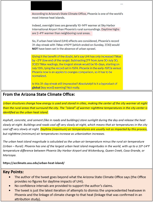
Yes, it’s small. Unfortunately, the tweet made an exaggerated claim and associated it with the Arizona State Climate Center. -
Occasional Thoughts on Climate Change
donsutherland1 replied to donsutherland1's topic in Climate Change
Climate change deniers are desperately trying to erase Phoenix's high-visibility 31-day heatwave from the record. The dishonesty involved has moved from attempts at deflection to citing sources that do not provide support for the inaccurate claims being made. Today, one found one of the more dishonest attempts on Twitter. The denier attributed urban heat island (UHI) effect data to the Arizona State Climate Office. UHI is real and its overwhelming impact is at night. The denier referenced a nighttime statistic (available on the Climate Office's website) and then inserted a daytime statistic (asserting that days are 2°-4° warmer) that is not provided on the website to advance his claim that the heatwave was not greater than the 1974 one (previous longest on record at 18 days) and that climate change didn't play any role in the longevity and intensity of the heat. In effect, the denier attempted to leverage the Climate Office's credibility to support a position that has no credibility. A Worldwide Weather Attribution Initiative study links the heat to climate change noting that the heat would have been "virtually impossible" without it. A separate Climate Central study also provides linkage to climate change. In response, I posted the below redacted information (highlights are mine) and notified the Arizona State Climate Office about the act of intellectual dishonesty in which its name was used improperly. Climate change deniers can make bogus claims and push falsehoods, but they do not have license to associate others with their claims. Manufacturing statistics and attributing them to credible sources that have nothing to do with those statistics, goes beyond speech. Doing so is dishonest, unethical, and damaging to the credibility of the abused sources.
-
Unless I am mistaken, the 60C figure was a surface temperature, not a 2 meter temperature. The ground is much warmer than air temperatures where the official readings are measured. I agree concerning the Southwest heat dome. Indeed, near record to record heat is likely later this week. So far, none of the guidance brings the warmth into eastern North America, but that could happen when a fundamental change in the pattern takes place. Chile had some wild heat today with locations in the Andes experiencing all-time highs in mid-winter!
-
Fair and pleasant days coupled with low humidity will continue through Thursday. No significant hot weather appears likely through the first week of August. In fact, the latest ECMWF weeklies show no notable heat through at least the first half of August. As has often occurred in areas witnessing prolonged sieges of heat in recent years, extreme heat will likely rebuild later in the week in the U.S. Southwest. Cities such as Del Rio, El Paso, Phoenix, and Tucson could approach or reach their August high temperature records. The ENSO Region 1+2 anomaly was +3.0°C and the Region 3.4 anomaly was +1.2°C for the week centered around July 26. For the past six weeks, the ENSO Region 1+2 anomaly has averaged +3.17°C and the ENSO Region 3.4 anomaly has averaged +1.05°C. El Niño conditions have developed and will likely continue to strengthen through at least the summer. The probability of an East-based El Niño event has increased. The SOI was -6.37 today. The preliminary Arctic Oscillation (AO) was -0.363 today. On July 30 the MJO was in Phase 1 at an amplitude of 0.686 (RMM). The July 29-adjusted amplitude was 0.445 (RMM).
-
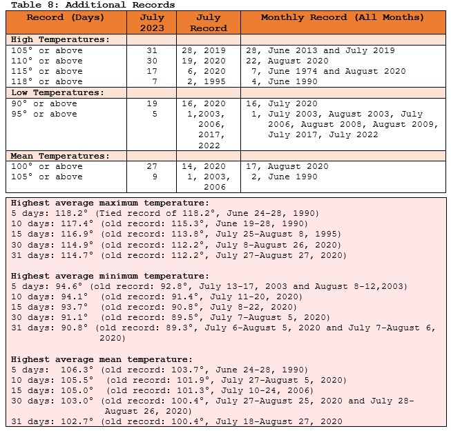
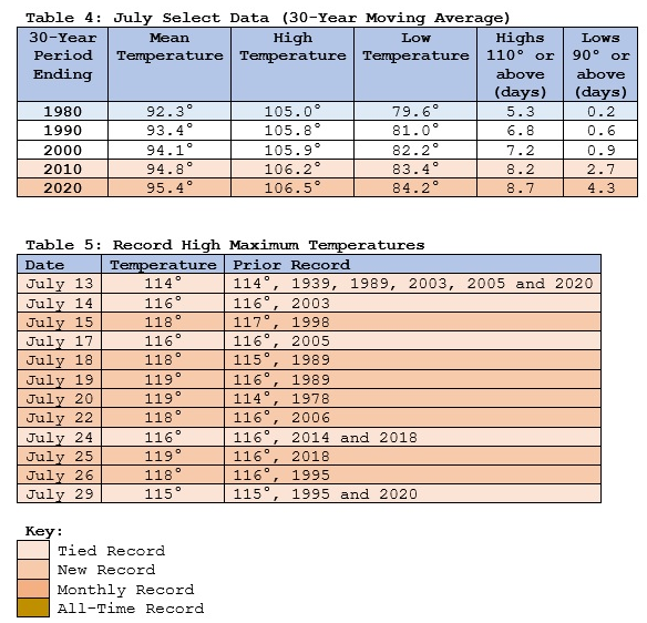
Thanks. Table 4 will be corrected.
-
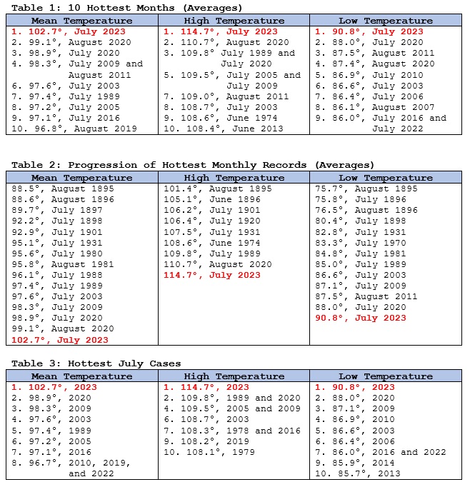
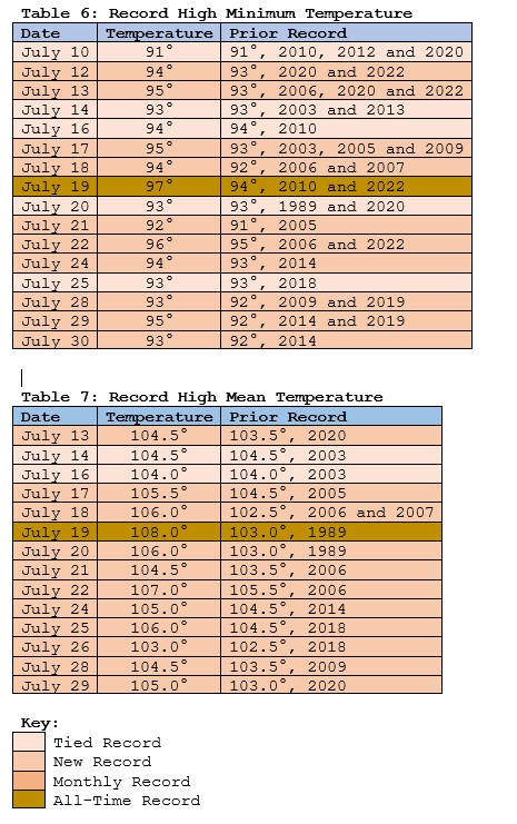
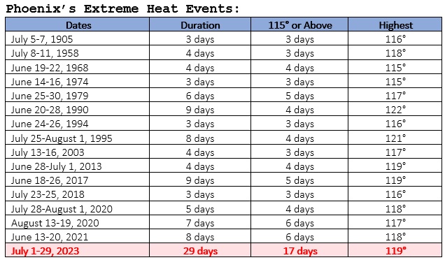
The heat… desiccates the unwary, its dryness sapping moisture from one’s mouth and eyes. Sweat evaporates too quickly to cool… –Thomm Quackenbush Powered by a heatwave without precedent—christened “Heatwave Chevron” by former Weather Channel meteorologist Guy Walton—Phoenix experienced its hottest July and month on record. The dynamic city of 1.6 million spent day after day under a broiling sun in a raging storm of brutal, unforgiving, penetrating heat. Nights offered little relief from the fierce heat. As a result, July 2023 left the prior hottest month, August 2020, in the dust much as Secretariat demolished the field in the 1973 Belmont Stakes. July 2023 surpassed the previous monthly mean temperature record by the largest margin by which any prior mark was surpassed. Phoenix also recorded the highest mean temperature and highest average low temperature for any month in any American city. The old records were a mean temperature of 102.2° and an average low temperature of 90.1° in Lake Havasu City during July 1996. Lake Havasu City also had an average high temperature of 114.4° during July 1996. Further, the lowest maximum temperature during July was 108°, which easily eclipsed the 104° mark from June 2013. In addition to the records that melted under the unforgiving Phoenix sun, the 2023 heatwave produced Phoenix’s longest extreme heat event on record. Extreme heat events are determined using the Clarke et al., 2014 methodology, which applies percentiles to summer high temperature values from the 1971-2000 baseline. To qualify, a period must have at least three 115° or above high temperatures, an average high temperature of 115° or above for the duration of the extreme heat event, and no high temperatures less than 110° during the extreme heat event. The Role of Climate Change Anthropogenic climate change is driving a warming of Phoenix's summers. This ongoing warming is a global phenomenon with 98% of the world having experienced its warmest 51 years during the current 2,000 years. The IPCC’s Sixth Assessment Report found that heat and heatwaves are increasing on every continent. The primary driver is human-caused climate change. Phoenix’s unprecedented heatwave and record hot month are the result of a combination of factors that includes climate change, which has boosted temperatures and led to “stuck” patterns, the Urban Heat Island Effect, which has raised nighttime temperatures, and the synoptic pattern in which a powerful heat dome developed over the region. The World Weather Attribution (WWA) Initiative found that the heatwave was “virtually impossible” without climate change and that temperatures were approximately 2°C (3.6°F) warmer on account of climate change. Event attribution studies calculate whether and the degree to which an event was made more (or less) likely and/or intense because of climate change. The WWA warned, “Unless the world rapidly stops burning fossil fuels, these events will become even more common and the world will experience heatwaves that are even hotter and longer-lasting.” Heatwaves of the magnitude of the 2023 heatwave could occur every 2-5 years in a world that is 2°C (3.6°C) warmer than the pre-industrial world. Summary The record-setting summer of 2020 was a “summer from the future,” as it resembled the kind of summers that will likely occur on a regular basis by 2050. Similarly, the great 2023 heatwave can be said to be a “heatwave from the future.” On account of the unparalleled heatwave, July went on to become Phoenix’s hottest month on record, by far. In her poem, "Heatwave...Pleiades," Elizabeth Squires wrote of a heatwave "hotter than Hades... haranguing us from dusk to dawn." That was Phoenix in July 2023.
-
Under bright sunshine, New York City saw the temperature top out at 85°. As a result, July finished with a mean temperature of 79.1°, which was 1.6° above normal. Fair and pleasant days coupled with low humidity will continue through at least midweek. No significant hot weather appears likely through the first week of August. As has often occurred in areas witnessing prolonged sieges of heat in recent years, extreme heat will likely rebuild later in the week in the U.S. Southwest. The ENSO Region 1+2 anomaly was +3.0°C and the Region 3.4 anomaly was +1.2°C for the week centered around July 26. For the past six weeks, the ENSO Region 1+2 anomaly has averaged +3.17°C and the ENSO Region 3.4 anomaly has averaged +1.05°C. El Niño conditions have developed and will likely continue to strengthen through at least the summer. The probability of an East-based El Niño event has increased. The SOI was +5.35 today. The preliminary Arctic Oscillation (AO) was -0.060 today. On July 29 the MJO was in Phase 8 at an amplitude of 0.472 (RMM). The July 28-adjusted amplitude was 0.303 (RMM).
-
August 2023 temperature forecast contest
donsutherland1 replied to Roger Smith's topic in Weather Forecasting and Discussion
DCA _ NYC _ BOS __ ORD _ ATL _ IAH ___ DEN _ PHX _ SEA 0.1 -0.5 -0.5 0.2 2.0 2.4 0.7 2.0 2.1 -
Under bright sunshine, readings topped out in the upper 70s and lower 80s today. Fair and pleasant days coupled with low humidity will continue through at least midweek. No significant hot weather appears likely through the first week of August. The extreme heat event that has gripped the Southwest for four weeks is concluding. Phoenix reached 110° for the 31st consecutive day a short time ago, but will likely stay below 110° tomorrow through Tuesday. However, the respite appears likely to be short-lived. As has often occurred in areas witnessing prolonged sieges of heat in recent years, extreme heat will likely rebuild later in the week. The ENSO Region 1+2 anomaly was +3.5°C and the Region 3.4 anomaly was +1.1°C for the week centered around July 19. For the past six weeks, the ENSO Region 1+2 anomaly has averaged +3.12°C and the ENSO Region 3.4 anomaly has averaged +1.00°C. El Niño conditions have developed and will likely continue to strengthen through at least the summer. The probability of an East-based El Niño event has increased. The SOI was +8.86 today. The preliminary Arctic Oscillation (AO) was +0.120 today. On July 28 the MJO was in Phase 8 at an amplitude of 0.304 (RMM). The July 27-adjusted amplitude was 0.374 (RMM). Based on sensitivity analysis applied to the latest guidance, there is an implied near 100% probability that New York City will have a warmer than normal July (1991-2020 normal). July will likely finish with a mean temperature near 79.0° (1.5° above normal).
-
I’m pretty sure it is an ash. I came across it during a morning walk. Limbs were downed in Scarsdale.
-
Uprooted tree from yesterday’s thunderstorm in southern Westchester County.


-
Following this evening's thunderstorm.


-
In the wake of the frontal passage, tomorrow will turn noticeably cooler and less humid. No significant hot weather appears likely through the first week of August. The extreme heat event that has gripped the Southwest for four weeks will conclude over the next day or perhaps two days. As has often occurred in areas witnessing prolonged sieges of heat in recent years, extreme heat could rebuild next week. The ENSO Region 1+2 anomaly was +3.5°C and the Region 3.4 anomaly was +1.1°C for the week centered around July 19. For the past six weeks, the ENSO Region 1+2 anomaly has averaged +3.12°C and the ENSO Region 3.4 anomaly has averaged +1.00°C. El Niño conditions have developed and will likely continue to strengthen through at least the summer. The probability of an East-based El Niño event has increased. The SOI was 0.00 today. The preliminary Arctic Oscillation (AO) was +0.163 today. On July 27 the MJO was in Phase 7 at an amplitude of 0.374 (RMM). The July 26-adjusted amplitude was 0.274 (RMM). Based on sensitivity analysis applied to the latest guidance, there is an implied near 100% probability that New York City will have a warmer than normal July (1991-2020 normal). July will likely finish with a mean temperature near 79.2° (1.7° above normal).
-
With the monsoonal moisture, it's unlikely. Monday and Tuesday will likely be in the 105-108 range. Heat should return afterward and the August monthly record high temperature could be challenged next Saturday. Phoenix will still have the warmest July in terms of average monthly temperature and average monthly low temperature of any U.S. city (Death Valley locations are hotter).
-
Tomorrow will be another very warm and humid day. However, strong thunderstorms could cross the region during the afternoon or evening as a cold front moves through. In the wake of the frontal passage, Sunday will turn noticeably cooler and less humid. The extreme heat event that has gripped the Southwest for four weeks is beginning to fade. The intense heat will continue to slowly fade over the coming days with the extreme heat ending on Sunday or Monday. As has often occurred in areas witnessing prolonged sieges of heat in recent years, there are some hints that the heat could rebuild next week. The ENSO Region 1+2 anomaly was +3.5°C and the Region 3.4 anomaly was +1.1°C for the week centered around July 19. For the past six weeks, the ENSO Region 1+2 anomaly has averaged +3.12°C and the ENSO Region 3.4 anomaly has averaged +1.00°C. El Niño conditions have developed and will likely continue to strengthen through at least the summer. The probability of an East-based El Niño event has increased. The SOI was -14.96 today. The preliminary Arctic Oscillation (AO) was +0.023 today. On July 26 the MJO was in Phase 8 at an amplitude of 0.275 (RMM). The July 25-adjusted amplitude was 0.219 (RMM). Based on sensitivity analysis applied to the latest guidance, there is an implied near 100% probability that New York City will have a warmer than normal July (1991-2020 normal). July will likely finish with a mean temperature near 79.3° (1.8° above normal).
-
A heatwave is continuing to develop in parts of the northern Mid-Atlantic region. Readings will likely climb into the middle and perhaps upper 90s again tomorrow. The humidity will add to the discomfort with heat indices again reaching or exceeding 105° tomorrow. The heatwave will not be a prolonged affair. Following a frontal passage on Saturday or Saturday night, Sunday will turn noticeably cooler and less humid. The extreme heat event that has gripped the Southwest for four weeks is beginning to fade. The intense heat will continue to slowly fade over the coming days with the extreme heat ending this weekend. As has often occurred in areas witnessing prolonged sieges of heat in recent years, there are some hints that the heat could rebuild next week. The ENSO Region 1+2 anomaly was +3.5°C and the Region 3.4 anomaly was +1.1°C for the week centered around July 19. For the past six weeks, the ENSO Region 1+2 anomaly has averaged +3.12°C and the ENSO Region 3.4 anomaly has averaged +1.00°C. El Niño conditions have developed and will likely continue to strengthen through at least the summer. The probability of an East-based El Niño event has increased. The SOI was -22.28 today. The preliminary Arctic Oscillation (AO) was -0.95 today. On July 25 the MJO was in Phase 7 at an amplitude of 0.215 (RMM). The July 24-adjusted amplitude was 0.280 (RMM). Based on sensitivity analysis applied to the latest guidance, there is an implied 98% probability that New York City will have a warmer than normal July (1991-2020 normal). July will likely finish with a mean temperature near 79.3° (1.8° above normal).
-
A heatwave is developing in parts of the northern Mid-Atlantic region. Readings will likely climb into the middle and perhaps upper 90s during the height of the heat. The humidity will add to the discomfort with heat indices reaching or exceeding 105° tomorrow and Friday. The heatwave will not be a prolonged affair. Following a frontal passage on Saturday or Saturday night, Sunday will turn noticeably cooler and less humid. An extreme heat event continues to grip the Southwest. Phoenix reached a daily record 118°. El Paso and Tucson recorded their 41st consecutive 100° days. The intense heat will slowly fade over the coming days with the extreme heat ending this weekend. As has often occurred in areas witnessing prolonged sieges of heat in recent years, there are some hints that the heat could rebuild next week. The ENSO Region 1+2 anomaly was +3.5°C and the Region 3.4 anomaly was +1.1°C for the week centered around July 19. For the past six weeks, the ENSO Region 1+2 anomaly has averaged +3.12°C and the ENSO Region 3.4 anomaly has averaged +1.00°C. El Niño conditions have developed and will likely continue to strengthen through at least the summer. The probability of an East-based El Niño event has increased. The SOI was -37.30 today. The preliminary Arctic Oscillation (AO) was +0.064 today. On July 24 the MJO was in Phase 7 at an amplitude of 0.225 (RMM). The July 23-adjusted amplitude was 0.245 (RMM). Based on sensitivity analysis applied to the latest guidance, there is an implied 97% probability that New York City will have a warmer than normal July (1991-2020 normal). July will likely finish with a mean temperature near 79.4° (1.9° above normal).
-
A heatwave is likely in parts of the northern Mid-Atlantic region. Parts of the region could see readings climb into the middle and perhaps upper 90s during the height of the heat. The humidity could add to the discomfort. At present, the potential heatwave does not appear to be a prolonged affair. An extreme heat event continues to grip the Southwest. Phoenix reached a daily record 119°. That was its third 119° temperature this year (old record: 2, 1990). El Paso and Tucson each registered their 40th consecutive 100° or above days, both of which are records. The ENSO Region 1+2 anomaly was +3.5°C and the Region 3.4 anomaly was +1.1°C for the week centered around July 19. For the past six weeks, the ENSO Region 1+2 anomaly has averaged +3.12°C and the ENSO Region 3.4 anomaly has averaged +1.00°C. El Niño conditions have developed and will likely continue to strengthen through at least the summer. The probability of an East-based El Niño event has increased. The SOI was -37.30 today. The preliminary Arctic Oscillation (AO) was +0.071 today. On July 23 the MJO was in Phase 7 at an amplitude of 0.245 (RMM). The July 22-adjusted amplitude was 0.479 (RMM). Based on sensitivity analysis applied to the latest guidance, there is an implied 97% probability that New York City will have a warmer than normal July (1991-2020 normal). July will likely finish with a mean temperature near 79.4° (1.9° above normal).