

yoda
-
Posts
63,582 -
Joined
Content Type
Profiles
Blogs
Forums
American Weather
Media Demo
Store
Gallery
Everything posted by yoda
-
Should be in the SPC archives ETA: @George BM beat me to it
-
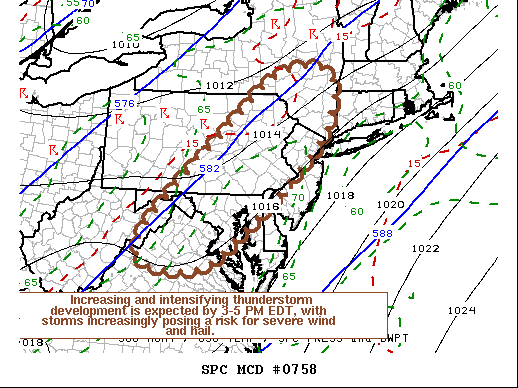
https://www.spc.noaa.gov/products/md/md0758.html Mesoscale Discussion 0758 NWS Storm Prediction Center Norman OK 1127 AM CDT Fri May 29 2020 Areas affected...Northern Mid Atlantic Coast region Concerning...Severe potential...Severe Thunderstorm Watch likely Valid 291627Z - 291730Z Probability of Watch Issuance...80 percent SUMMARY...Thunderstorms may develop across the Poconos and Catskills vicinity as early as the next hour or or so, with a more general increase and intensification of thunderstorm during the 3-5 PM EDT time frame. With strongest storms expected to pose at least a risk for severe wind and hail, one or more severe weather watches seems probable. DISCUSSION...Insolation within a seasonably moist boundary layer (surface dew points around/above 70F) is contributing to moderately large CAPE on the order of 1000-2000+ J/kg, within deepening surface troughing to the lee of the Appalachians. Mid-level flow remains broadly anticyclonic, however deepening convective development is underway aided by orography, particularly across the Poconos into Catskills vicinity. As a short wave trough accelerates northeast of the middle Ohio Valley/central Appalachians region, mid-level flow appears likely to trend increasingly cyclonic across northern Virginia through eastern New York state. This should contribute to an environment increasingly conducive to thunderstorm initiation and intensification. A coinciding strengthening of southwesterly mid-level flow (30-50 kt around 500 mb), will provide sufficient shear for organizing lines and clusters of storms, with isolated discrete supercells also possible. At least some of this activity will pose a risk for large hail, potentially damaging wind gusts, and perhaps a tornado or two. ..Kerr/Grams.. 05/29/2020 ...Please see www.spc.noaa.gov for graphic product... ATTN...WFO...OKX...ALY...PHI...BGM...AKQ...CTP...LWX..
-
Severe tstorm watch coming soon for C VA into C PA
-
From the SPC 4-8 day OTLK disco:
-
2/15/15 on the new Day 1 OTLK
-
This looks fun
-
00z HRRR has some morning activity between 09z and 11z coming up from the south into DC metro... nothing severe... but might make for quite a soupy airmass in the morning as the sun appears... waiting for the rest of the run to see what happens in the afternoon around here ETA: Nothing really through 23z so far... kinda surprised tbh
-
BULLETIN - EAS ACTIVATION REQUESTED Tornado Warning National Weather Service Lincoln IL 720 PM CDT Thu May 28 2020 The National Weather Service in Lincoln has issued a * Tornado Warning for... Central Moultrie County in central Illinois... * Until 745 PM CDT. * At 717 PM CDT, a confirmed landspout tornado was located south of Dalton City, or about 3 miles northwest of Bethany, moving east at 30 mph. HAZARD...Very weak or landspout tornadoes. SOURCE...Weather spotters confirmed landspout tornado. IMPACT...Expect damage to mobile homes, roofs, and vehicles. * The tornado will be near... Bethany around 720 PM CDT. Sullivan and Lovington around 735 PM CDT.
-
This afternoons LWX severe threat disco for tomorrow... mentions cap for i95 corridor till evening... also mentions supercells possible
-
For Friday, day 2 morning SPC OTLK
-
MRGL risk for Day 1... 2% TOR and 5% wind... for i95 corridor and west TOR risk is from N VA into C PA on day 1 OTLK No real disco for our area though besides few short sentences lol SLGT for day 2 for most of LWX CWA... 2% TOR and 15% wind... potential for greater tornado risk stated in disco on day 2 btw... all depends on low level flow and surface wind direction
-
SLGT risk for extreme Eastern IA into N IL including Chicago on new day 1... 15% hail and 5% tor
-
For those that want to look at the 5/31/2008 event - https://www.spc.noaa.gov/exper/archive/event.php?date=20080531 ETA -- 120 hours would be the weekend, yes? Saturday or Sunday? And could you link me to the CIPS severe again? I lost my link
-

Upstate NY Banter and General Discussion..
yoda replied to wolfie09's topic in Upstate New York/Pennsylvania
If you live in Binghamton... article says not in Western New York. Perhaps later maybe... nice to see snow in Buffalo today though -
LWX afternoon AFD seems to be suggesting that the front didnt get as far south as they thought it would... so places up by DC may be in the game this evening for a severe storm
-
00z NAM and 3km NAM sim radar look interesting around 03z/04z MON... I guess some sort of an MCS? Both 00z WRF-ARW and 00z WRF-ARW2 keep majority of storms down by EZF 00z WRF-NMM looks more like the NAM twins but is an hour or 2 faster 00z HRDRPS looks fun DC south
-
18z NAM soundings at KIAD for 00z MON and 03z MON looked pretty good to me... decent SBCAPE and shear... would suggest that the WF or west to east front is somewhere in C MD Sim radar didnt look too bad on either of the 18z NAMs or RGEM... 18z long range HRRR did suggest though that the front is in N VA as it has best storms just south of me toward EZF
-
00z 12km NAM looks decent... has what looks to be a complex of storms (MCS?) Roll through the DC metro region around 03z MON 00z 3km NAM NEST looks intriguing from 00z to 04z MON... looks like a sup comes rumbling down i66 corridor from 02z to 04z
-
Ah, ping pong ball hail to maybe golf ball then... guess our ML Lapse rates are good enough?
-
I think it will depend on where the front (warm front?) sets up shop... could maybe be an isolated tornado if it rides the west to east front? And big hailers are what to you? The usual quarter to half dollar size around here or bigger?
-
5% tor in IL/SE IA/NE MO in new day 2
-
LWX in their evening AFD update now mentions a risk for a few thunderstorms tomorrow afternoon... so I guess they are leaning toward HRRR?
-
Maybe a lil something? Day 2 morning OTLK from SPC
-
https://mobile.twitter.com/Cyclonebiskit/status/1250882075999080448
