

yoda
-
Posts
63,579 -
Joined
Content Type
Profiles
Blogs
Forums
American Weather
Media Demo
Store
Gallery
Everything posted by yoda
-
Numerous trees down in Albermarle county Emergency management reports numerous trees down near Great Cacapon as well
-
Trained spotters reported damage to trees in NW Hardy county
-
Lol 4 warnings already from LWX... watch till 10pm... and it's too late?
-
SPC added a small MRGL risk for damaging winds tomorrow in their 1730z SPC OTLK update for parts of the LWX CWA
-
First STW of the day down in Nelson/Augusta counties... moving NE. Winds to 60mph and quarter size hail
-
Watch disco did mention afternoon hail threat with discrete storms which may have transient supercell characteristics too. Wind probs in the watch are 50/10... hail probs 30/20
-
80% chance of a watch from C VA to C PA... MCD just issued
-
@high risk is correct... new morning Day 1 OTLK has SLGT for most of LWX CWA... 5% hail and 15% wind 0600z OTLK disco:
-
Maybe some get the storms warned in N WV that are moving SE later?
-
Very interesting notes from SPC today about May 2020 severe weather wise
-
I've been watching some of what has been going on in MN/WI... and seems like HRRR was a big whiff
-
SPC morning Day 2 disco
-
-
SPC morning Day 2 has moved SLGT risk south some... it is now just north of a Harrisonburg, VA to EZF line.... 2/15/15
-
So looks like we probably have 2 chances then... Wednesday afternoon into night and then again Friday afternoon
-
Afternoon AFD from LWX discussing severe for Wed to Fri time period:
-
Has this mainly been on the NAM? Or has the GFS and EURO been having the same? And those are some large matches by hail size... probably helped by the eastward moving EML with between 7.5 and 8.0 C/KM mid level Lapse rates
-
Well I hope people aren't expecting 2012 to be walking through the door... cause that's just silly
-
I consider low to mid 90s a hot air mass with DPs near 70
-
Will be interesting to see what the Day 3 SPC OTLK looks like
-
00z NAM showing ML Lapse Rates around 7.0 C/KM for Wednesday afternoon into the evening
-
https://www.spc.noaa.gov/exper/archive/event.php?date=20000809 All the watches, MCDs, and text products issued during the day... plus storm reports as well
-
Should be in the SPC archives ETA: @George BM beat me to it
-
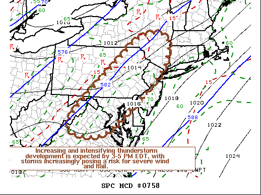
https://www.spc.noaa.gov/products/md/md0758.html Mesoscale Discussion 0758 NWS Storm Prediction Center Norman OK 1127 AM CDT Fri May 29 2020 Areas affected...Northern Mid Atlantic Coast region Concerning...Severe potential...Severe Thunderstorm Watch likely Valid 291627Z - 291730Z Probability of Watch Issuance...80 percent SUMMARY...Thunderstorms may develop across the Poconos and Catskills vicinity as early as the next hour or or so, with a more general increase and intensification of thunderstorm during the 3-5 PM EDT time frame. With strongest storms expected to pose at least a risk for severe wind and hail, one or more severe weather watches seems probable. DISCUSSION...Insolation within a seasonably moist boundary layer (surface dew points around/above 70F) is contributing to moderately large CAPE on the order of 1000-2000+ J/kg, within deepening surface troughing to the lee of the Appalachians. Mid-level flow remains broadly anticyclonic, however deepening convective development is underway aided by orography, particularly across the Poconos into Catskills vicinity. As a short wave trough accelerates northeast of the middle Ohio Valley/central Appalachians region, mid-level flow appears likely to trend increasingly cyclonic across northern Virginia through eastern New York state. This should contribute to an environment increasingly conducive to thunderstorm initiation and intensification. A coinciding strengthening of southwesterly mid-level flow (30-50 kt around 500 mb), will provide sufficient shear for organizing lines and clusters of storms, with isolated discrete supercells also possible. At least some of this activity will pose a risk for large hail, potentially damaging wind gusts, and perhaps a tornado or two. ..Kerr/Grams.. 05/29/2020 ...Please see www.spc.noaa.gov for graphic product... ATTN...WFO...OKX...ALY...PHI...BGM...AKQ...CTP...LWX..
-
Severe tstorm watch coming soon for C VA into C PA


