

yoda
-
Posts
63,578 -
Joined
Content Type
Profiles
Blogs
Forums
American Weather
Media Demo
Store
Gallery
Everything posted by yoda
-
June 4th and June 10th and June 16th 2008 were MOD risks... but for wind down here
-
I believe this is the last event that had hatched tor probs in the LWX CWA https://www.spc.noaa.gov/exper/archive/event.php?date=20160224
-
Evening AFD LWX disco update for tomorrow
-
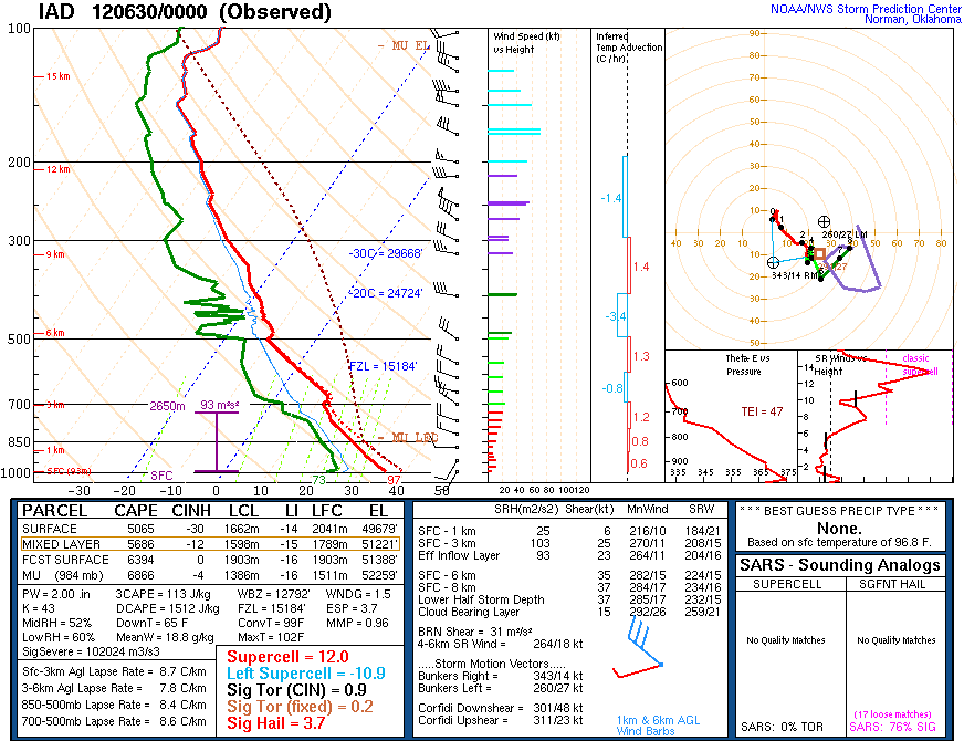
Those were at KIAD... KDCA and KEZF look a bit more nasty... along with KBWI too ETA: especially that sounding at KBWI at 00z Friday
-
Again with the no sprinkler
-
Those are some nasty soundings on the 00z NAM from 18z THURS to 03z FRI
-
Are we going to use this thread for both days? Or should we risk getting denied by posting a separate thread lol
-
Tornado watch coming shortly
-
LWX goes big for today and tomorrow in their morning AFD
-
SPC doesn't like today for us... but tomorrow... woah at the disco... here is the morning Day 2
-
00z NAM soundings for both tomorrow and Thursday look pretty nice... Thursday looks a lil better IMO due to a bit stronger deep layer shear
-
8pm TWO mentions 30 percent chance for that to develop 1. Showers and thunderstorms associated with a small area of low pressure about midway between the Windward Islands and west Africa appear to be slowly becoming better organized. Some additional development of this system is possible this week as the system meanders in the central tropical Atlantic Ocean. * Formation chance through 48 hours...low...20 percent. * Formation chance through 5 days...low...30 percent.
-
MRGL remains for Day 2 on 1730 SPC OTLK... but talks of an upgrade
-
Now let's see if this system sneaks in a quick name change from TD 15 to Omar before its gone
-
True. You could only go high risk here if the event was unfolding with as you say numerous tornadoes (EF2 or something) or a derecho coming in from the west. The derecho in 2012 however, caught the region, including local TV mets off-guard per the NWS report though.
-
Here's the sounding
-
I don't think we will ever see a high risk here -- even the derecho in late June that was rampaging through the Ohio Valley the night of the infamous 00z LWX sounding (102/70 I think it was with nearly 6000 SBCAPE) only garnered a moderate risk on the 2000 SPC OTLK and the 0100 OTLK
-
Ding ding. 100% correct. Part of it also is the $15 per hour push (though I admit that I pushed for it as well) for many of the jobs by today's younger generation as well. Many of the younger generation that are coming out of HS into college don't want to do what they consider as menial jobs. In addition, if it gets "too hard", they quit.
-
That does look like a pretty good sounding for an isolated brief tornado or two
-
Tropical Depression Fifteen Discussion Number 4 NWS National Hurricane Center Miami FL AL152020 1100 AM EDT Tue Sep 01 2020 The depression has become better organized this morning with the center embedded in the western side of a growing area of deep convection. An earlier buoy report recorded adjusted maximum winds of 32 kt, and roughly half of the estimates show that the depression is a tropical storm. Conservatively, the winds will be held at 30 kt until we will see what the scatterometer shows this afternoon. Increasing shear is expected to limit any significant strengthening, although it does seem more likely than not that this system will barely make it to a tropical storm later today. The shear is forecast to get quite strong by tomorrow afternoon, so weakening is anticipated by then, and persistence of that shear is expected to cause the cyclone to decay into a remnant low in about 48 hours. While the initial part of the forecast is a little higher than the last one, this change is really in the noise level for intensity prediction and is only noticeable because of the tropical storm threshold. The initial motion has turned toward the east-northeast or 060/12 kt. There is reasonable agreement among the guidance that this motion will continue through tomorrow, and then become eastward during the next 2-3 days around the northern side of the subtropical ridge, followed by a northeastward turn by day 4. Similar to the last forecast, most of the uncertainty is with the speed, rather than the direction of the cyclone. The new forecast is closer to the faster guidance and the previous NHC track prediction. Dissipation is shown at 120h, although a few models have it occuring as early as days 2-3. FORECAST POSITIONS AND MAX WINDS INIT 01/1500Z 34.7N 73.1W 30 KT 35 MPH 12H 02/0000Z 35.6N 71.1W 35 KT 40 MPH 24H 02/1200Z 36.5N 68.3W 35 KT 40 MPH 36H 03/0000Z 37.2N 65.1W 30 KT 35 MPH 48H 03/1200Z 37.3N 62.1W 25 KT 30 MPH...POST-TROP/REMNT LOW 60H 04/0000Z 37.0N 59.5W 25 KT 30 MPH...POST-TROP/REMNT LOW 72H 04/1200Z 37.0N 57.5W 25 KT 30 MPH...POST-TROP/REMNT LOW 96H 05/1200Z 39.5N 52.5W 25 KT 30 MPH...POST-TROP/REMNT LOW 120H 06/1200Z...DISSIPATED $$ Forecaster Blake
-
TD 15 remains at 5am... not going to make it to TS Nana per disco, should be gone in a few days as shear destroys it
-
No recon till later today... and no LLC (or no closed surface wind circ as said above in the 2am TWO) no upgrade at 5am
-
MRGL risk tomorrow for wind... SLGT risk for Thursday
-
NHC still says no at 2 am on their TWO about it due to no closed surface wind circ... which I guess means no closed LLC Tropical Weather Outlook NWS National Hurricane Center Miami FL 200 AM EDT Tue Sep 1 2020 For the North Atlantic...Caribbean Sea and the Gulf of Mexico: The National Hurricane Center is issuing advisories on Tropical Depression Fifteen, located a little over a hundred miles south of Cape Hatteras, North Carolina. 1. A seemingly well-organized cluster of showers and thunderstorms associated with a tropical wave is moving quickly westward across the central Caribbean Sea, but satellite-derived wind data from a few hours ago again showed that the system has not developed a closed surface wind circulation. The wave is, however, producing an area of winds near tropical storm force south of the coast of Haiti, which will move near or south of Jamaica later this morning. Environmental conditions are expected to become a little more conducive for development, and a tropical depression is likely to form during the next couple of days before the system reaches Central America Wednesday night. Locally heavy rains and gusty winds are possible on Jamaica today, and interests there, as well as in northern Nicaragua, Honduras, Belize, Guatemala, and the Yucatan Peninsula, should monitor the progress of this disturbance. * Formation chance through 48 hours...high...70 percent. * Formation chance through 5 days...high...70 percent. 2. A tropical wave is expected to emerge off the coast of Africa in a day or so. Gradual development of this system will be possible through the end of the week while it moves slowly westward over the far eastern tropical Atlantic Ocean. * Formation chance through 48 hours...low...near 0 percent. * Formation chance through 5 days...low...30 percent.
-
Too many people are making jokes about the ops (main models) past few days showing nothing... that's why. Just wanted to be sure. It's on tropical tidbits. Click ensemble... then gfs-para. Then you can choose the hours you want to look at from there on the scroll button


