

Dunkman
-
Posts
2,115 -
Joined
-
Last visited
Content Type
Profiles
Blogs
Forums
American Weather
Media Demo
Store
Gallery
Everything posted by Dunkman
-
mPING is a mess in central NC. I don’t know what people are doing but I’ve seen plain rain reported where it’s 22 degrees and snow in places where it hasn’t snowed in 4 hours.
-

Winter Storm Izzy Obs Thread
Dunkman replied to Prismshine Productions's topic in Southeastern States
Yeah people seem to remember the NAM wins and forget the miserable showings in between. HRRR seems promising for limiting ZR accumulation in NC. Hopefully it’s not too bad. -
Winter Storm Izzy Obs Thread
Dunkman replied to Prismshine Productions's topic in Southeastern States
Changing over here right now in north High Point. 1.5” of snow, maybe 2 if I’m being generous. -
Really rooting for the upstate people. Someone needs to get a good event out of this outside of the mountains!
-
They’re usually very conservative I’m happy to see those snow numbers so high after today’s runs.
-
Yeah I don’t think that’s the reason it’s so quiet. Every suite of models has been worse than the one before it for like 4 days. Eventually it just gets depressing.
-
I always thought the weather flow tempest looked really neat but I don’t have one.
-
It’s kind of amazing that we’re gonna miss again. It’s been since 2018. This is how long we went between good snows when I grew up in Beaufort.
-
Just as long as it’s not ZR here I won’t complain. Most of my house has Covid right now and the prospect of dealing with no power and falling trees is a little overwhelming (we’re all vaccinated and fine but still).
-
My experience has been the RGEM seems to do well farther north but has a pretty lousy track record figuring out p-type for winter storms in our region. That said I doubt we’ve had a winter storm to track here since it upgraded so who knows.
-
37 months since we’ve cracked 2”. I really thought this was gonna be it!
-
We don’t need a lot of ZR here, at least in the Triad, after the tropical storm conditions with the last storm. I’d imagine a lot of trees are barely upright.
-
I mean I’ve seen snow stick well when it was 70 the day before but I don’t know about when it was 70 the entire month before. Excited to have something to track though!
-
I feel like things went reasonably well in Louisiana all things considered? I mean we had a legitimate verified on the ground high end category 4 storm make landfall then sit on a swamp for many hours and refuse to weaken. That’s always going to be very, very bad. The transmission tower going down seems like something that shouldn’t happen but who knows. Could have been faulty construction and could have also been the mesovortices that persisted well inland in the eyewall.
-
I have a crazy amount of respect for what LEK says. He’s been right on it A LOT over the years.
-
This is not a good take. I grew up on the coast and we dealt with many hurricanes. Whether or not to evacuate is a difficult, complicated decision in many cases.
-
Anyone have a link to the Cancun radar that’s not the crappy accuweather (or equivalent) version? Thanks.
-
...FLASH FLOOD EMERGENCY FOR CITIES OF CANTON AND CLYDE AND PIGEON RIVER VALLEY TO LAKE WATERVILLE... The National Weather Service in Greenville-Spartanburg has issued a * Flash Flood Warning for... Central Haywood County in western North Carolina... * Until 215 AM EDT. * At 830 PM EDT, Significant rainfall totaling 4-7 inches has been observed across Haywood County, especially in the Pigeon River headwaters south of Canton. This is producing a significant and life-threatening flood wave moving down the Pigeon River through Canton, Clyde, and into Lake Waterville. Haywood County Emergency Management is requesting residents near the Pigeon River, including in the cities of Canton and Clyde, to evacuate to higher ground immediately. Evacuees are being asked to shelter at Tuscola High School. This is a FLASH FLOOD EMERGENCY for Cities of Canton and Clyde and Pigeon River Valley to Lake Waterville. This is a PARTICULARLY DANGEROUS SITUATION. SEEK HIGHER GROUND NOW!
- 310 replies
-
- 1
-

-
- late freeze
- warm
- (and 3 more)
-
I didn’t see it posted but there’s a high risk from the WPC for today ...THERE IS A HIGH RISK OF EXCESSIVE RAINFALL IN AND NEAR WESTERN NORTH CAROLINA... ...East/Southern and Central Appalachians... For the Southern Appalachians, Fred is expected to track very near to west of the area, initially bringing upslope flow of ~40 kts and ML CAPE up to 2000 J/kg into the region. Just to the west, Fred's comma head rain pattern is expected to lead to heavy rainfall west of the chain, which some feeder bands in its wake possibly impacting western slopes as well. While model guidance showed disperson, it did not where it mattered most in the western Carolinas. The border of Transylvania/Jackson County NC was hit with heavy rainfall Monday morning, with 4-9" reported. This is also where the guidance projects another 7"+ of rainfall on Tuesday and Tuesday night. With an additional 10" possible locally, and the 00z HREF indicating a 90% chance of exceeding the 100 year recurrence interval, coordinated with the GSP/Greer SC forecast office to issue a High Risk area covering from the vicinity of Asheville NC southwestward to near the SC/NC/GA border junction. This degree of rainfall could lead to landslides/slope failures. The risk of land slips as well as scattered to numerous flash flood events extends across the Moderate Risk area encompassing terrain of northeast GA, northwest SC, and the remainder of western NC. A broad area of 4-8" is expected. A broader Slight Risk encompasses where rain bands could set up across the FL Big Bend early and SC during the morning/afternoon as well as areas which have received 200-400% of their two week average rainfall near the Fall Line in VA and MD, and includes the D.C. area. Impacts across PA and NY should be mitigated by below average rainfall over the past couple of weeks.
- 310 replies
-
- 3
-

-
-
- late freeze
- warm
- (and 3 more)
-
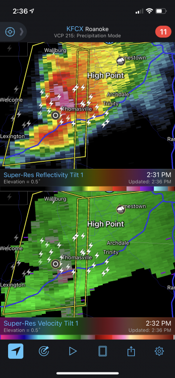
Looks like a pretty stout hail core and some rotation heading towards jburns.
-
I’m not an expert but when there’s a severe thunderstorm warning from Lenoir to Bluefield it might be time for a watch.
-
38 and 0.26" so far. 0 days since last 30 degree rain.
-
Playing the is it pollen or Covid game wasn't super fun. Hopefully my pandemic anxiety is a little better by now.
-
At least we’re going to have a mix of temperatures for our rain coming up instead of just 30s. Should be some 40 degree rain, some 50 degree rain and maybe even some 60 degree rain!
-
Hey it’s up to 41 now! Heat wave!


