

kvskelton
-
Posts
300 -
Joined
-
Last visited
About kvskelton

- Birthday 11/02/1964
Recent Profile Visitors
2,452 profile views

.thumb.jpg.9707d4addca3d84715ae3d888c5c10d6.jpg)


-

Jan 30th-February 1st 2026 Arctic Blast/ULL Snow OBS Thread.
kvskelton replied to John1122's topic in Tennessee Valley
Not an actual ob, per se, but my son (who works there) just let me know that ETSU is closing at 2pm. -
582 FXUS64 KMRX 281732 AFDMRX Area Forecast Discussion National Weather Service Morristown TN 1232 PM EST Wed Jan 28 2026 ...New DISCUSSION, AVIATION... .KEY MESSAGES... Updated at 1229 PM EST Wed Jan 28 2026 - It will be dry but temperatures will remain below normal today through Thursday. - Snow is increasingly likely Friday afternoon through Saturday, especially in the eastern and northeastern portions of the region. - Arctic cold will return for the weekend. .DISCUSSION... We remain under broad eastern CONUS troughing aloft, with surface high pressure currently over our region. This set up will keep us dry but with below normal temperatures through Thursday night. By Friday, models are in general agreement that a strong short wave will be diving southeast out of the Plains, cutting off by Saturday as it tracks over our area and then lifting off to our northeast Sunday. A weak surface low pressure system is forecast to develop near the northern Gulf and then move east and offshore the SE coast before strengthening rapidly as it tracks to the northeast off the East Coast. This system will bring at least some light snow to the area, and in this case precipitation type is not in question but the uncertainty lies in how much snow will fall. Right now it appears we will have light snow begin to show up Friday especially north as we see weak isentropic lift out ahead of the main system. Then, as the upper low approaches and the upper jet to its south noses in, we will see a period of upper divergence that will enhance snow chances. Of course, the exact track of the upper low and the surface low to our SE and E will be critical, and the models often struggle with these details even just a few days out. Right now, the best chances for significant snow accumulations look to be over our eastern and northern areas. Currently, NBM probability data shows around a 40% to 60% chance of 72 hour snowfall exceeding 4 inches by Sunday morning across our northern and central mountains as well as eastern portions of the NE TN valley and SW VA, and a 20% to 50% chance of exceeding 2 inches of snow across much of the central valley, northern Plateau, and western portions of NE TN. Orographically enhanced snow showers may linger into Sunday across the normally favored terrain as well. The other story for the weekend will be the cold. Another surge of arctic air will rush in on north and northwest winds, and high temperatures Saturday will struggle to get above the lower 20s even in the valleys. Low temperatures Saturday night will be in the single digits in most areas. Wind chill values will dip into the single digits in the valleys with well below zero values at times in the higher terrain as well Friday night through Saturday night. Sunday will likely see temperatures remaining below freezing for nearly all of the area, and Sunday night will to be very cold as well. Models are in general agreement that we will see height rises aloft and gradually moderating temperatures Monday through Wendesday. There is poor agreement on additional waves that may bring precipitation, but there is at least a modicum of agreement for more precipitation chances arriving by Wednesday. && .AVIATION... (18Z TAFS) Issued at 1229 PM EST Wed Jan 28 2026 VFR conditions expected through the period, besides a brief TEMPO for MVFR CIGs at TRI this afternoon. Winds will be gusty at TRI this afternoon through early evening with gusts to around 24kts out of the west. Otherwise, mostly quiet conditions through the next 24 hours. && .PRELIMINARY POINT TEMPS/POPS... Chattanooga Airport, TN 22 42 26 43 / 0 0 0 20 Knoxville McGhee Tyson Airport, TN 20 39 25 40 / 0 0 0 30 Oak Ridge, TN 19 38 24 40 / 0 0 0 30 Tri Cities Airport, TN 14 34 21 37 / 0 10 0 50 && .MRX WATCHES/WARNINGS/ADVISORIES... NC...NONE. TN...NONE. VA...NONE. && $$ DISCUSSION...99 AVIATION...99
- 782 replies
-
- 3
-

-
- extreme cold
- snow
- (and 1 more)
-
6z Euro appears to be underway once more on Pivotal. Just FYI.
-
Not sure if the 6z model froze at hour 57 but the Euro results on pivotal sure did! Sent from my SM-S926U using Tapatalk
-
Maybe just a touch between hours 72 and 75? Regardless, that would be brutal for Chattanooga if that GFS run verifies.
-
Amen, brother. Hope you get well soon, John.
-
Fall/Winter Banter - Football, Basketball, Snowball?
kvskelton replied to John1122's topic in Tennessee Valley
I, for one, am always lurking around here during severe and winter seasons, John. You might say I'm like athletes foot; you can get rid of me but I keep coming back. So bring on the clown maps, dry slots, warm noses and cold rain! I'm ready for winter in the Valley! -
Sounded like someone was landing a jet in my wife's back yard this morning. Now being reported as a 4.1 centered near Maryville. https://earthquakelist.org/news/2025/05/10/m4-1-earthquake-the-united-states-1104168/ Sent from my SM-S926U using Tapatalk
-
Right there with you, Icy Hot. Hopefully the dry air will be overcome for us soon! Happy for everyone else that has scored so far!
-
Guilty as charged!
-
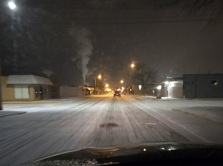
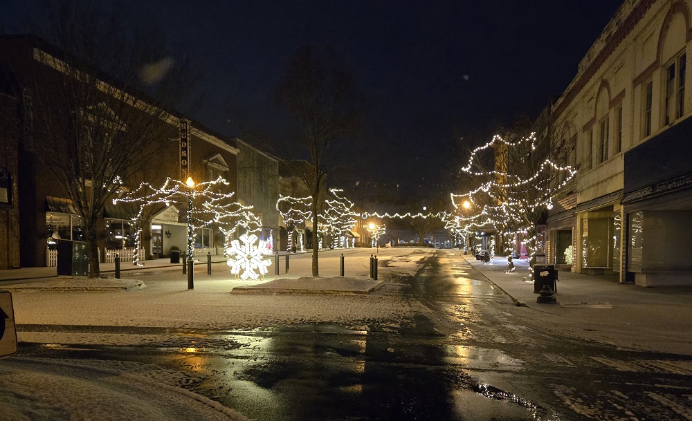
A couple quick photos I took this morning on my way into the office about 6:50am. Market Street and then Broad Street in downtown Kingsport. More just to show the conditions than for their artistic or aesthetic value.
- 284 replies
-
- 11
-
-

-
Same here. Just walked outside in Kingsport to warm my car up before work and was shocked to see about a half inch of snow on everything and light snow still falling. Roads haven't been touched. Might be an interesting ride to work!
-
Summer-Fall 2024 Weather Disco Med/Long Range
kvskelton replied to John1122's topic in Tennessee Valley
Brightridge reporting 390 outages involving over 4000 customers. They cover the Colonial Heights area of Kingsport, as well as Johnson City.- 688 replies
-
- 1
-
-
- heat
- thunderstorms
- (and 7 more)
-
Summer-Fall 2024 Weather Disco Med/Long Range
kvskelton replied to John1122's topic in Tennessee Valley
I have to admit, in nearly 60 years of being on this rock I don't think I've ever seen this notation in a NWS forecast for any of our surrounding area:
- 688 replies
-
- 4
-
-
- heat
- thunderstorms
- (and 7 more)
-
Summer-Fall 2024 Weather Disco Med/Long Range
kvskelton replied to John1122's topic in Tennessee Valley
High Wind Warning issued portions of east TN and SW VA starting at 8pm tonight and running through 8pm Friday. URGENT - WEATHER MESSAGE National Weather Service Morristown TN 1251 PM EDT Thu Sep 26 2024 TNZ012>017-035>040-042-044-046-067>071-073-081>086-098>101-VAZ001- 002-005-006-008-270400- /O.UPG.KMRX.HW.A.0006.240927T0000Z-240928T0000Z/ /O.EXA.KMRX.HW.W.0008.240927T0000Z-240928T0000Z/ Scott TN-Campbell-Claiborne-Hancock-Hawkins-Sullivan-Morgan- Anderson-Union-Grainger-Hamblen-Northwest Cocke-Northwest Greene- Washington TN-Northwest Carter-Roane-Loudon-Knox-Jefferson- Northwest Blount-North Sevier-Sequatchie-Bledsoe-Rhea-Meigs- McMinn-Northwest Monroe-Marion-Hamilton-Bradley-West Polk-Lee- Wise-Scott VA-Russell-Washington VA- Including the cities of Big South Fork National, Dandridge, Madisonville, Kingston, Appalachia, Arthur, Bristol VA, Benton, Grandview, High Point, Jasper, Bullet Creek, Honaker, Huntsville, Morristown, Lake Forest, Melvine, La Follette, White Pine, Kodak, Rosedale, Elizabethton, Russellville, Oak Ridge, Reliance, Pardee, Newport, Johnson City, Pine Orchard, Evanston, Sneedville, Alpha, Etowah, Petros, Conasauga, Hiltons, Chattanooga, Harriman, Treadway, Norma, Lone Mountain, Clear Water, Eagle Furnace, Bristol TN, Alcoa, Palio, Mount Crest, Harrogate-Shawanee, Whitwell, Cleveland, Bybee, Athens, Jefferson City, Pikeville, Hansonville, Tasso, Chestnut Hill, Cartwright, Elk Valley, Howard Quarter, South Pittsburg, Smokey Junction, Luttrell, Fairview, Fincastle, Rockwood, Oneida, Knoxville, Lookout Mountain, Cagle, Benhams, Strawberry Plains, Clairfield, Lebanon, Rose Hill, Oliver Springs, Harrisburg, Happy Valley, Signal Mountain, Norton, Loudon, Spring City, Abingdon, Dentville, Clinton, Lenoir City, Sevierville, Sweetwater, Monteagle, Kyles Ford, Paulette, Seymour, Lone Oak, Coeburn, Big Stone Gap, Norris Lake, Pigeon Forge, Caryville, Royal Blue, Big Spring, White Oak, Powells Crossroads, Maynardville, Elgin, Mooresburg, Jellico, South Holston Dam, Springdale, Wise, Old Washington, Bradbury, Sharps Chapel, Brayton, Archville, McMahan, Parksville, Sandlick, Martin Springs, Kingsport, Slick Rock, Bean Station, Old Cumberland, Bearden, Maryville, Greeneville, Haletown (Guild), Evensville, Dunlap, Castlewood, Dye, and Dayton 1251 PM EDT Thu Sep 26 2024 /1151 AM CDT Thu Sep 26 2024/ ...HIGH WIND WARNING IN EFFECT FROM 8 PM EDT /7 PM CDT/ THIS EVENING TO 8 PM EDT /7 PM CDT/ FRIDAY... * WHAT...East to northeast winds 20 to 30 mph with gusts up to 65 mph expected. * WHERE...Portions of east Tennessee and southwest Virginia. * WHEN...From 8 PM EDT /7 PM CDT/ this evening to 8 PM EDT /7 PM CDT/ Friday. * IMPACTS...Damaging winds will blow down trees and power lines. Widespread power outages are expected. Travel will be difficult, especially for high profile vehicles. PRECAUTIONARY/PREPAREDNESS ACTIONS... Remain in the lower levels of your home during the windstorm, and avoid windows. Watch for falling debris and tree limbs. Use caution if you must drive.
