IUsedToHateCold
-
Posts
838 -
Joined
-
Last visited
Content Type
Profiles
Blogs
Forums
American Weather
Media Demo
Store
Gallery
Everything posted by IUsedToHateCold
-
I like my chances for a first freeze for IAD, BWI, and RIC
-
Current GFS also puts RIC in the possibility category for the next week (it has an even lower temperature than BWI for Wed morning)
-
Local weatherbug has 34. Decent frost on the roof and the car.
-
Today very well may be the warmest day at DCA this month.
-
I had to go out for a walk tonight just to take in the clear sky.
-

My 2022-23 winter outlook & "what went wrong" Post-mortem
IUsedToHateCold replied to Terpeast's topic in Mid Atlantic
Great write-up, I agree with just about everything (perhaps a warmer anomaly for November and January). I do think there will be 2-3 weeks in late Dec-early Jan that could be productive for us in the snowfall department. It's a roll of the dice. -
Why would we believe it wouldn't? Add that the current CONUS temperature anomalies for this month look nothing like that map of October '00. We're seeing above average anomalies in the west/mid-west this year. I actually cannot remember a month where we had wall-to-wall below average temperature departures for the entire CONUS in the past 10 years.
-
Could the GFS have been right? Heavy rain doesn’t look to let up soon.
-
Yeah nobody is talking about the rain for NC and SC, with the modeled track it’s bound to be a flooding hazard
-
I'm not sure about snowfall, but this is what I'm currently thinking for temperature departures: November: torch (maybe warmest ever?) December: -1 to -2 January: 0 to +1 February: +4 March: -2 The thinking is an eastern trough in the first half of meteorological winter with a ridge in the second half, with the trough returning in March.
-
BWI- 10/25 IAD - 10/24 DCA -12/2 RIC - 10/25 Peak Oct temp at DCA- 84 degrees
-
This is the weirdest modeled track for a tropical system I’ve ever seen
-
Hopefully this morning’s cool temperatures will help kick things off around here so our peak isn’t in mid November and I’m not cleaning up leaves at Christmas like last year.
-
September is our driest month climatologically. It'll get wetter in October.
-
Oscillations aside, the tonga eruption is going to be the x-factor in this year’s prediction. Given this, I would predict the weather will likely be more abnormal than usual in either a good or bad way for our subforum. It’s less likely to trend closer to the average, IMO.
-
Notice windows fogged up then stepped outside, feels like a sauna out there. Local weatherbug shows dew point of 75
-
2022 Atlantic Hurricane Season Tracking Thread
IUsedToHateCold replied to WxWatcher007's topic in Mid Atlantic
Crucify me, but I’m not rooting for tropical. Last two low seasons for the Atlantic were excellent snowfall years (2009 and 2014). Let’s keep that basin empty. -
Easily could see an October with at least one 90 degree day early in the month followed by wintery precip for some places late in the month. Would be the kiss of death for winter though, so I wouldn’t root for that.
-
All yours!
-
The problem with comparing maps, indices, and analog years is that even if the anomalies are very similar, they are usually not exactly the same. Those tiny differences matter. Don’t stick a fork in it.
-
Another 3 inches per radar. I’ve now got a leak in my roof. Can I send this rain somewhere else!?
-
The cold pool in the GOA is definitely a difference, even if the rest is a good match. 50-51 was a lackluster year for Baltimore. 6.2 inches for the season.
-
72 degrees and humid out. Light to moderate rain at times.
-
2022 Mid-Atlantic Severe Wx Thread (General Discussion Etc)
IUsedToHateCold replied to Kmlwx's topic in Mid Atlantic
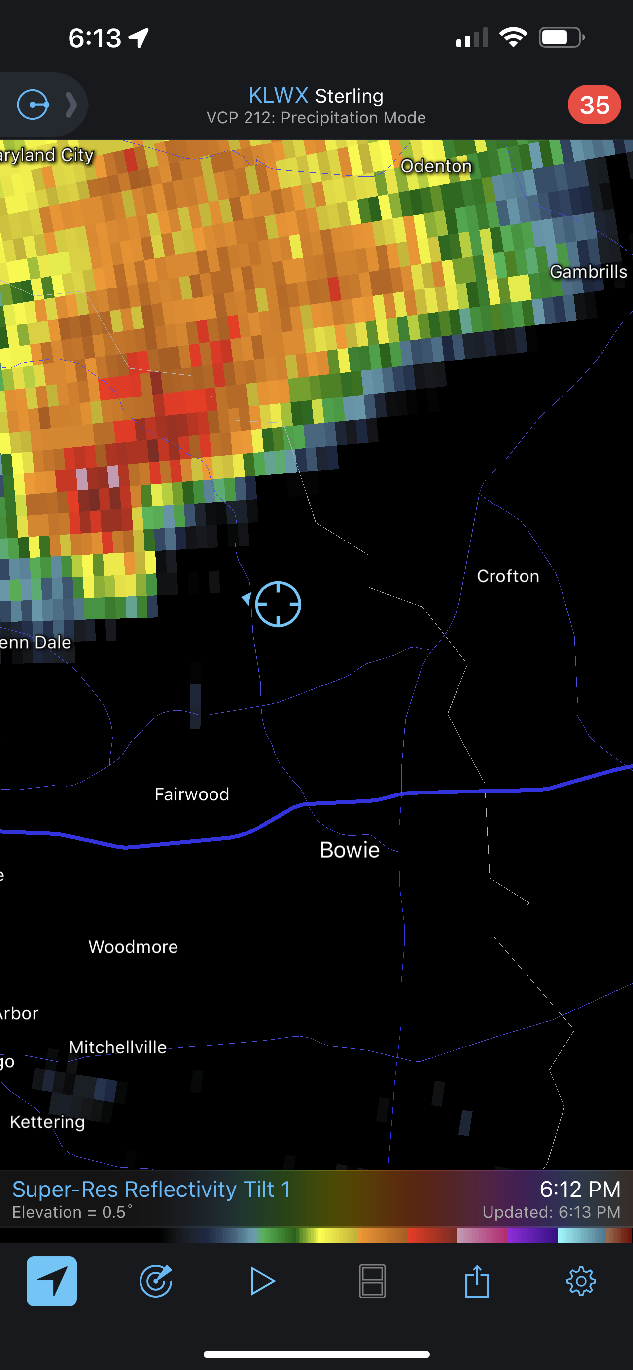
The eyes of doom are set on me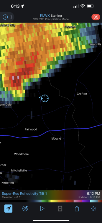
-
The trend I see in Nina years for our area is small to moderate events. They're mostly suppressed and clip our area from the S/E, favoring areas east of the fall line but not packing a huge amount of punch in terms of totals. We also see plenty of cutters and systems impacting PA. We seem to be lacking big epic storms like 2016 in these years, but we can nickle-and-dime ourselves to around climo (slightly below or above)