

Terpeast
-
Posts
6,591 -
Joined
-
Last visited
Content Type
Profiles
Blogs
Forums
American Weather
Media Demo
Store
Gallery
Everything posted by Terpeast
-
For the MA, phase 7 is a transition phase. It is usually the precursor to big storms. Not always, but some.
-
0.27"
-
Fell short of 50 today, high of 49. Felt like winter!
-
Yes. -50 inches Joking aside, I’m thinking more a 2000-01 / 2017-18 winter here, fast start in december, normal transitory january, then february torch. But if the SSW happens and the aftereffects last long with the lag Chuck keeps mentioning, we may extend the good start to cover 2/3 of the winter season. Won’t take much to get us to climo, with march as a cherry top if we can get anything out of that month (which we haven’t in a long time - we’re due)
-
Welp, I went even lower than him. I'd be happy to be wrong, in our favor.
-
Low of 24, coldest so far
-
28.9
-
BWI: 11.2” DCA: 9.8” IAD: 13.5” RIC: 5.8” (Tiebreaker) SBY: 8.6”
-
Nothing yet, hopefully something pops within a couple hours
-
Thank you for saying the quiet part outloud. I have him on ignore anyways.
-
I absolutely agree with this. Same for LA and FL getting 10"+ and a 4 degree low soon after. I'm not at all worried about losing the big ones. Just that they might be spaced out in larger intervals instead of every 3-7 years between 1979 and 2016.
-
Only down to 29.8, thought it’d be 28 or lower
-
That winter, particularly February, was notable because of a huge noreaster from NJ north, and Mt Washington got 49" in 24 hours, or a total of 91" over 3 days. See 100 hour snowstorm: The 100-Hour Snowstorm of February 1969 | NOAA Climate.gov Another one just before that hit western NC and northern SC with up to 2 feet. There was a thread about it on this very forum: February 1969 Foothills/Piedmont Deep Snowstorm - Southeastern States - American Weather There was almost no noteworthy events for Dec and Jan. With strong greenland blocking and a strong aleutian ridge, it was probably cold and dry along the SE and east, much like a modern La Nina pattern we've been seeing over the last several years - only colder. In a modern climate, probably little or no snow, just a few degrees warmer. Then in Feb, a ridge began to build over the rockies while the greenland block continued, and then those two big storms happened.
-
With a SSW/weak PV being forecast this month, I checked when the last time we had a SSW in November. 1968. So I looked up the 1968-69 analog, and most of the teleconnections match. -QBO, -PDO, +AMO, etc... except it was a weak nino, not a nina. It was a very cold winter, averaging roughly -5 through DJFM, snowfall was backloaded apart from an early November snow. With this winter being a weak nina, snow might be more front-loaded and may be colder than what seasonal models are depicting, assuming the SSW verifies.
- 827 replies
-
- 10
-

-

-

-
Would you say that the PNA pushing positive despite the +WPO/Pacific marine heat wave is what's behind some of the suppressed storm tracks that gave Louisiana and Florida and SE VA double digit snows? That's just me visualizing the patterns in my head... but I haven't really looked at the PNA data (been heads down with MJO at work lately).
-
That’s my baby son’s due date…
- 827 replies
-
- 10
-
-
And the north pacific pattern isn't permanent either. It'll change at some point, maybe back to what it was before the extreme long-duration negative PDO... or take a different form altogether. My wag is that the NE Pac might be next to get a long-duration marine heat wave (selfishly good for us weenies, but disastrous for many ecosystems and livelihoods up and down the western NA continent)
-
Agreed. As depicted, this is a mountains special, which isn't uncommon in November.
-
While their snowfall map was reasonable, I would have broadbrushed the 12-18" zone more evenly from the mountains all the way eastward to the beaches, and then cut the numbers by 70%. So basically 9-14" for the entire midatlantic outside of the higher elevations.
-
Wow, what a cell that came through. Driving rain, couldn’t see houses across the street, trees thrashing about. Better than most summer tstorms, and wild that its only 53 out. 1.62” so far
-
Not as familiar with their climo as I am for the MA, but I’d venture a guess towards 10-15”, 20+ north of metro
-
Here's my winter outlook. (more of the same...)
-
My outlook. May do Edition 2 if things change in November. Or maybe not.
-
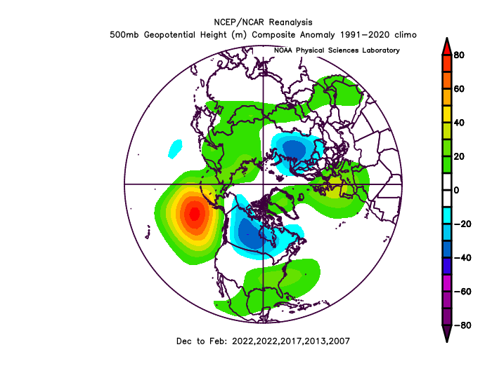
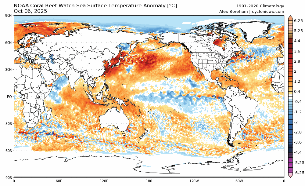
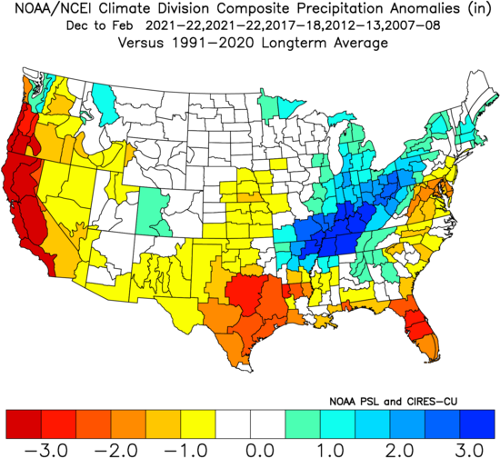
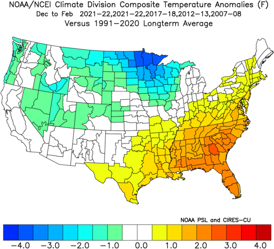
Not a whole lot has changed this month, so I decided to go ahead and issue my outlook for this winter. I'll keep it brief and simple: Overall winter feel: Meh, but not full-on blowtorch. Cool ENSO/weak basin-wide Nina coupled with -QBO Strong -PDO trying to turn the corner but not quite getting there -IOD bracketing MJO activity to phases 3-7 with limited 8-1-2 activity More weak troughing east of Japan pushing N. Pac High east into GOA (this helps us) Mostly -PNA, but with some +PNA episodes with plenty of Canadian cold air to tap into Weakly +NAO on the means with at least 2 or 3 bonafide -AO/-NAO blocking episodes Snowfall guess: 9-11" for the forum, maybe a few inches more for CAPE and northward of him Predicted mean DJF NH Pattern based on listed analogs (2021-22 weighted twice): SST changes last 15 days: Extrapolating cool SST/troughing east of Japan while warm blob pushes to the east. Cool area in GOA probably will not last. Atlantic pattern seems neutral towards NAO bias, but increased risk of SE ridge linkage with -NAO. Temp and Precip DJF Maps: Warmer and drier across the SE. Mild East Coast, but not torchy, plenty of cold air to tap into, but timing and SE ridge linkage will be an issue to contend with at times. Rockies, Upper MW, Great Lakes, and non-coastal SNE and all of NNE are poised to have a great winter.
- 3 replies
-
- 17
-
-

-
That’s one of my top analogs, too. Another one high on the list is 2017-18

