Terpeast
-
Posts
6,687 -
Joined
-
Last visited
Content Type
Profiles
Blogs
Forums
American Weather
Media Demo
Store
Gallery
Everything posted by Terpeast
-
Makes sense. iirc the deamplification trend usually starts at 3-4 days out, no? otoh, the high moved way off to the east and we need it to stay to the north of us.
-
Yeah I don’t like the less confluence part either. Looks more like 6z
-
You just said my quiet thought out loud. The 12z gfs took a step closer to euro compared to 0z, so we’ll see if this is the start of a trend.
-
Models want to add more ridging across the polar domain. This may be the early effects of the recent SSW and if well timed with the next mjo 8 wave, this could set us up nicely for late dec - early jan. Still expecting a mid month relaxation where we warm up for a week or so.
-
Yeah, according to hovmollers the models are trending towards weaker forcing at 6/7 after Dec 7. Between now and Dec 7, we have a clean mjo 8 pass. Then weak forcing reappears at 6/7, which is strongest with gefs. But even the gefs begins to propagate that eastward after Dec 7-10. So we may yet get another mjo 8 pass soon afterward. MC ssts also have been cooling recently:
-
Happy Thanksgiving everyone!
-
Taken verbatim, if this were happening two weeks later it would be snow for everyone. It’s just so early. But this is just one gfs run and its still 5-6 days away.
-
Fwiw gefs has stronger high this run vs last
-
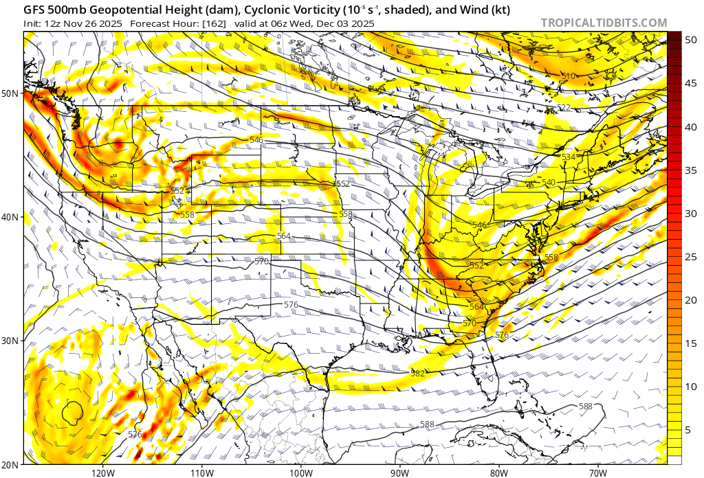
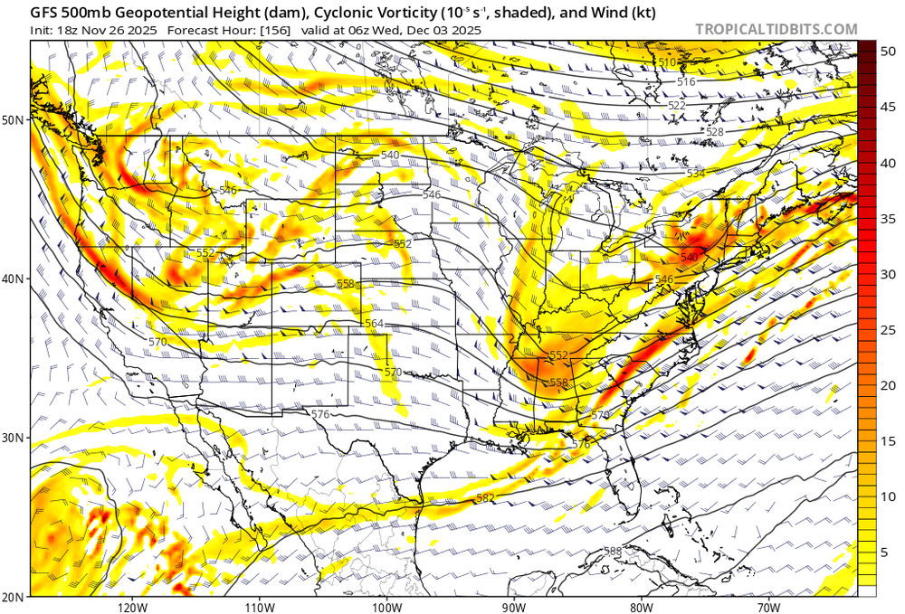
Gfs also has two vorts in one system, which it didn’t have before. Previous run: This tells me that gfs may be struggling to resolve active pieces of energy off the pacific and rounding the bottom of the TPV. We’ll see whether these vorts get consolidated back into one like previously, or whether one vort is “favored” over the other. That can result in big differences in both track and timing, and of course ptype.

-
Yeah, gfs has been trending more and more amped the last 4-8 runs. Mostly rain for us. We’ll see if this breaks the deamplification trend that’s been around for 2 years, or if that gets us back in the game.
-
True, but more and more members falling below the mean and even reversing. Still very far out and can/will change a ton, though.
-
First mention of dec 2 system from LWX Forecast confidence decreases markedly by Tuesday. On the synoptic scale a shortwave embedded within a much broader longwave trough encompassing much of the CONUS is expected to lift northeastward out of the base of the longwave trough and interact with what should be a sharp baroclinic zone in place along the East Coast. Various sources of both deterministic and ensemble guidance show a large amount of spread with respect to what will ensue with this system. Some solutions show large precipitation totals, while others show little precipitation at all. Some show snow, some show a wintry mix, and others show plain rain. As is typical, temperatures look to be colder the further north and west one goes, so those locations have a greater chance to experience wintry precipitation if it were to occur. It`s too early to get into details at this point, but this system will be one to monitor over the next several days, as it has at least a chance to bring portions of the area their first wintry precipitation event of the year.
-
Hit 70 today. Probably the last one for a while.
-
It's early and cold air is iffy down here, but the midwest storms today and Nov 30 will pay a role in laying down snow cover and reducing modification of cold air setting us up for the threat next week.
-
It will be interesting to see whether this split forcing, if it happens, is a continuation of the VP standing wave over the MC, or is a second wave propagating eastward from MJO 6>7>8>1. There is agreement that the first (current) wave is going to propagate into 8 and 1 in the coming days (according to both GEFS and EPS hovmoller charts), which makes sense as we're already tracking some wintry threats on the way next week. (and when I say wintry threats, I'm not saying it's going to snow imby, just talking generally over a broad area in the E and NE)
-
Nice looking runs, but let's not get too excited until we get within 5 days. It's not even December yet, so let's hold until Black Friday. If the models are still doubling down then, this may be a real threat to contend with.
-
I think it might be later than that, if we even see sustained phase 8.
-
It looks like this is our first window (I'm on the very very southern edge of it so not expecting much). After this first window, the PNA looks to go pretty deeply negative then rise back to neutral-ish by mid-month. Then we should get another window sometime after that.
-
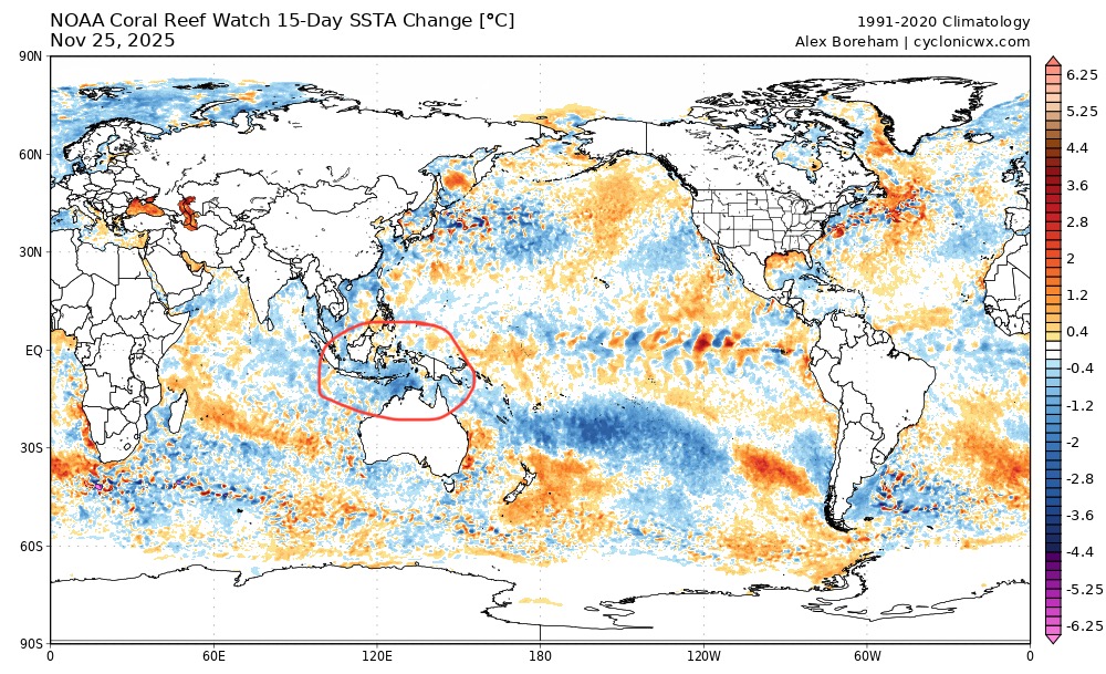
The return of the blob? Btw, thanks for posting the model forecast change loops. If you look to the left at the north pacific, notice the lines tightening meaning the models underestimate the pac jet and it gets stronger as it gets closer in time. That nudges north pac ridging to the north and east into the EPO domain, which means more cold for midwest and possibly the east. The SST change map also seems to reflect this tendency.
-
Yeah, I saw that. It’s actually “ahead” of the euro now.
-
That's the dream ain't it?
-
And so is the tropics. Same run tries to brew a hurricane in the Caribbean in fantasy range.
-
Same page, I'm still thinking January is the cold month for the east. Best chance for MA snows before Feb torch. Dec isn't really in play for us down here imho
-
Here’s hoping for the best case scenario - current wave propagates east, lays down tracks for warmer surface/subsurface waters for the next mjo wave going well into 8 and 1 in jan/feb, while confining the nina to east based. Could turn out to be a fun winter if that happened. EPS tries to do this, but GEFS has been better with MJO. We shall see
-
Careful, we don’t want the nina to fade too fast. Winters with a nina that quickly fades to neutral by Jan tend to be less snowy than those that fade more slowly.