Terpeast
-
Posts
6,687 -
Joined
-
Last visited
Content Type
Profiles
Blogs
Forums
American Weather
Media Demo
Store
Gallery
Everything posted by Terpeast
-
It was my first winter back in the area since 2016, and that jan blizzard was still fresh in mind when I was telling my wife what to expect from the winters here. Maybe I jinxed it
-
Funnily enough, the last time we had a really cold xmas was in dec 2022. Torchapalooza afterward. So if there is going to be a torch, I’ll take one before prime climo.
-
You’re not the only one
-
Lots of cold air lurking just up north. This warm up won’t last long. Unfortunately it may happen right at xmas
-
As I said in the MA forum yesterday, it won’t take much to shift that wpac warm pool slightly east to favor MJO 7-8 instead of 4-6. MJO 7 has sometimes shown to be a precursor to our biggest storms. And while the warm up is getting more aggressive on the models, my overall thoughts have not changed about 1) Neg WPO, 2) cold air source in Canada, 2) MJO waves into 7 and 8, and 4) increased chance of blocking due to stratosphere activity. These will increase the likelihood of a cold January moreso than a warm one.
-
It won’t take much. We need it to move to phase 7 because that’s the precursor to our biggest storms. Ideal scenario is we get the standing wave on 7, and periodically we’d get incursions into 8>1>2, and then rotate back to 7.
- 827 replies
-
- 12
-

-

-
My thoughts about the long term pattern and late month warm up:
-
You‘re right about that, this doesn’t seem like a typical La Nina, even though cold decembers do follow the nina pattern. We have three defining features right now: 1) Stratosphere activity 2) MJO activity in phase 7-8 and/or split forcing 3) Strong -WPO Even with a warm up this month, the models maintain all three features and in conjunction they lead to a cold January based on historical analog matches. If - and a big IF - we lose ALL three features by January (strong SPV, MJO 3-4-5, +WPO that scours cold air out of Canada), January will torch like 2006 and 2017. But right now, I don’t see us losing any one of these features.
-
Went down to 12! Now 20
-
Congrats central and S VA folks! Enjoy it!
-
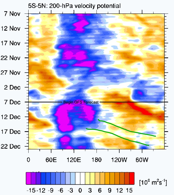
After several 11-15 day warm ups have failed to materialize in the past few months, I remain skeptical of such warm ups in the near future. Of course that will change, and my guess as to when the next extended warm up will be is february. We may get mild for a week or so mid-Dec, but I think its only temporary. I drew in green below the next mjo wave to get out of the MC. There is a hint of this even within the 5N-5S band (its stronger with 15N-15S and thus more influential). So I wouldn’t be surprised to see that hint strengthen into a signal that’ll eventually play out and bring us back to colder weather in late Dec into Jan.

-
12/5: 1.5” (based on spotter report picked up by LWX, not by my own measurement)
-
Baby Terpeast was born this morning, and both he and Miss Terpeast are doing well. Thanks for all the support and kind words (and the laughs from all these shoe jokes). And there was about 1.5” on the ground when I had a chance to go outside and get our stuff for the overnight hospital stays. Which is the same as the local Ashburn report for LWX. Looked like a real winter wonderland outside the 4th floor window. Today was a great day!
-
Popping in, at the hospital now. Just waiting for them to get the baby out. They did not treat the roads, so I drove us through the snow. Already had 1” on the ground and the roads were completely covered, and was coming down at a moderate clip. Everything was white. But we made it, and so did the surgeon. As soon as the WWA was cancelled over Loudoun county, that band came up and just sat over us.
-
34/21
-
My bad, that was the 18z NAM 3k. Was on mobile and thought I clicked to HRRR but the screen somehow reset. I’ll edit my post.
-
If radar trends hold, yes
-
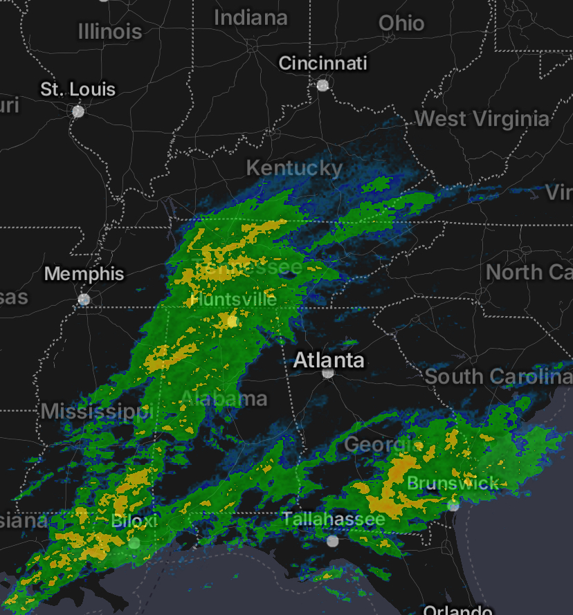
I just compared radar with the 18z 3k NAM sim for the same valid time (00z, which is now). Actual radar shows echos north of the TN/KY border, model doesn’t. Northern extent may be underdone, and perhaps a bit too slow.

-
My baby son is due tomorrow morning, so it may very well be that we'll be driving through the snow on slippery roads to get to the hospital. It won't take much snow to make the roads dicey especially with cold temperatures overnight. Fortunately it's only a 10 minute drive and we'll give ourselves extra time to get there. Will probably be busy over the next couple of weeks, but I'll try to pop in here if there's something else to track. May it snow tomorrow and everyone gets at least 1"!
-
Trending down, yes, but the thing is AAM forecasts have been biased too negative over the past 30 days. When correcting for that, AAM may be closer to neutral.
-
Not too familiar with cville microclimate but I'd worry about downsloping since the flow is basically east to west. Perhaps 1-1.5" is a safe bet for you. Just basing this on the HRRR and ignoring the NAM, which is about to get retired.
-
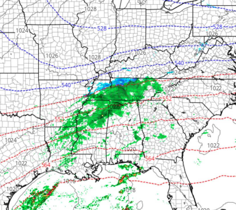
Yeah, its almost back to where 00z was, not quite as beefy but the northern extent is back up just north of the dc metro - and I'm looking at 1km radar not composite reflectivity. I wouldn't count us out yet. Just to clarify, my expectations are coating to 1" tops north of 66/50 up to 70
-
Low of 23.5
-
On the plus side, the -WPO should chip away at the negative PDO and maybe even set us up for end of month into January
-
Yeah, that alaska vortex needs to move norther or weaken. Otherwise, it won't let shortwaves dig enough for us to develop storms with enough gulf moisture.