Terpeast
-
Posts
6,687 -
Joined
-
Last visited
Content Type
Profiles
Blogs
Forums
American Weather
Media Demo
Store
Gallery
Everything posted by Terpeast
-
Not only did gfs shift, it expanded its precip extent north. Lets keep this trend going.
-
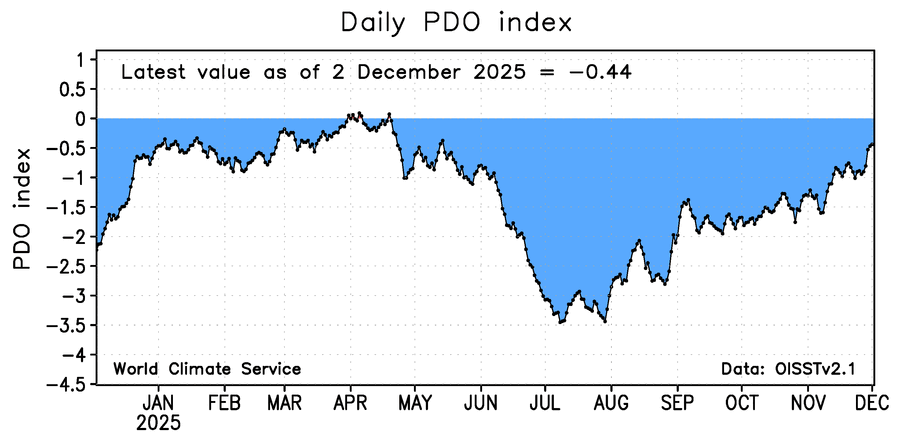
We’re ahead of last year wrt PDO…
-
Are you talking about Jan 2024? From 3-5 days out they were progged to hit PA and ensembles only had us at an inch or less, then they shifted south to give us the max.
-
Difference is they both trended south from above. We need a north trend on this one. If that trough over northern Maine can move out a little quicker, we can reel it in.
-
Sold!
-
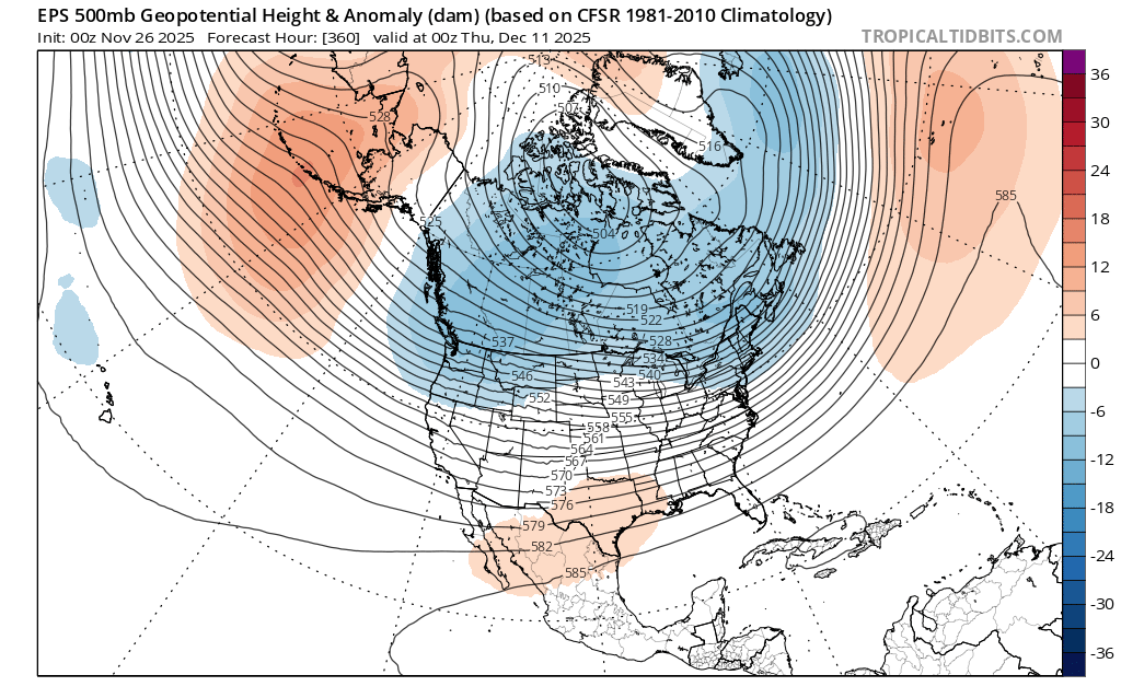
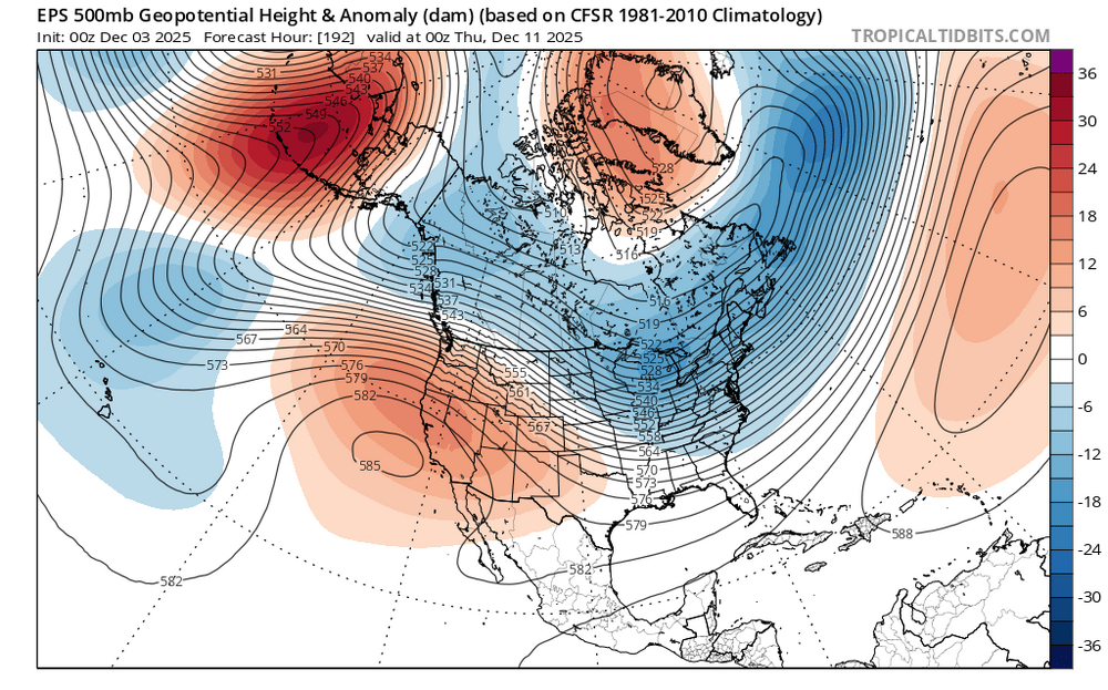
I'd be careful in cancelling any warmup because both ensembles try (operational word, "try") to send a trough into the western US giving us a bootleg -PNA. But any warmup appears to be only temporary. Maybe a week or so, or even a few days. When I play out the roll forwards from 11-15 to 6-10, that western trough retrogrades NW and instead pops up a flat ridge there instead, allowing cold air to move SE across the CONUS. For example, comparing 360 hr from Nov 26 against 192 hr from today's EPS run, you can see what I'm getting at. Old run (11/26): New run (today):

-
Here’s one I like (sadly it only goes up to 2013) http://www.raymondcmartinjr.com/weather/1996/Weather.html Gives me a nice trip down memory lane having lived through many of these storms. There are many maps at all levels of the atmosphere that shows the evolution of each storm. You’ll notice that the most powerful winter storms have a dual jet structure, where the low develops under the overlapping of both the left exit of one jet streak and the right rear entrance of another jet streak. Like double jeopardy. Rare, but truly amazing when it happens, and thats why they get so powerful. Look at the blizzard of 1996, perfect textbook example.
-
I didn’t think he was being sarcastic. Snowenouthere has been dropping dimes lately, hopefully he keeps it up.
-
I was a little confused by your question, so I had to reread a few times. Correct me if I’m wrong, but I think what you are asking is why the low doesn’t develop right under the strongest winds of a jet stream. You’d be correct in your observation that it usually develops downstream of a trough where upper level winds diverge, air lifts, and surface pressure decreases. When the vorticity “stretches”, we get an elongated region of positive vorticity advection as opposed to concentrated into a tight vort max over one area. That spreads upper level forcing for lifting over a large area, thereby “diluting” the tendency for a surface low to form. So it’s not so much the sfc low doesn’t “prefer” to be away from the strongest winds, but more like it tends to deepen where that elongated band of vorticity overlaps the divergence (left exit/right entrance regions) and the baroclinic gradient. While vorticity alone isn’t enough to develop a storm, that combined with upper level support will do it - there needs to be both. The displacement you’re noticing is really a reflection of where the total forcing (vorticity and upper level divergence) both line up, which often ends up a bit downstream and to the left of the jet streak, not directly under the strongest winds. Now when the jet core “rounds the base” of the trough, you’re right that we’re often getting into the mature phase of the storm. By that point, the upper level trough and the surface low have gotten more vertically stacked, and the low begins to occlude and weaken. Sorry if this got too technical, but your question covers several different meteorological concepts, and the evolution of a cyclone where conditions differ between the early stages of development and when it matures.
-
Left exit and right entrance regions, where upper level flow diverges. Conservation of mass and surface boundary dictates that air must lift to replace the diverging flow.
-
Gfs going back and forth, we got plenty of time for that one
-
Gfs may be more interested in the follow up wave (dec 8-9)
-
Got 0.82”, most in months.
-
Idk, warm nose all the way up to the M/D line. Week later we would still have mixed. End of month would have been snowier. It was just not a cold system this time.
-
Not very shoetastic, isn't it? Ah well, we'll get plenty of other chances down the pike.
-
Plain cold rain. 34
-
Big slug of heavy moisture coming your way. I think you'll be good
-
That would be a lot of freezing rain down this way if RGEM is correct.
-
34.2, gah. Wet bulb at 30
-
26.6/23
-
Bottomed out at 27.1, now 27.3
-
LCPS 2 hour delay 27.9/23.1
-
Temp drop is slowing down. 28.6/22.6.
-
Just checked all the mesos forecasts of 2m temp at valid 00z 12/2 (which is right now), and they are all too warm. The closest one is fv3 Doesn’t mean anything about upstairs, but surface is colder than forecast.
- 750 replies
-
- 13
-

-
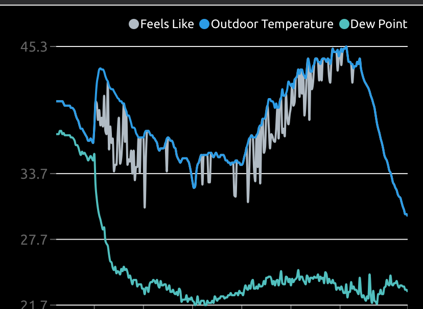
My high was 45, and then dropped like a rock.