Terpeast
-
Posts
6,687 -
Joined
-
Last visited
Content Type
Profiles
Blogs
Forums
American Weather
Media Demo
Store
Gallery
Everything posted by Terpeast
-
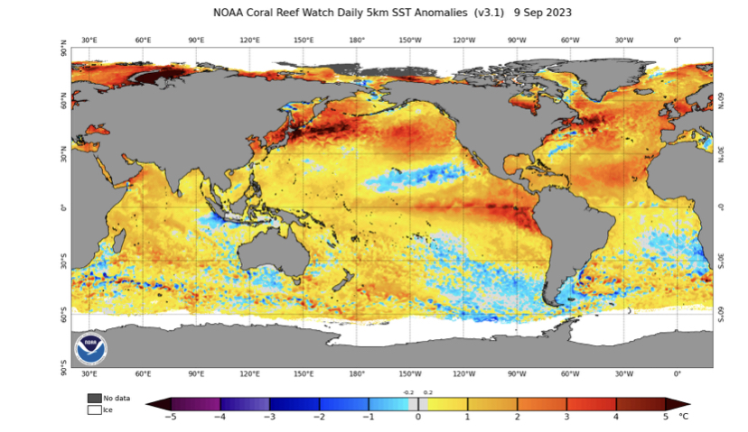
Map like that, I could see increased high latitude blocking which would be good for us, but at the same time, it’s hard to see how an aluetian low could plant itself there for longer periods of time. Hopefully it’s just the surface and when strong storms go through they’ll erase some of the sst warming. Probably will see an aleutian ridge pop up now and then while that happens.
-
The first thing I’d do is to pull the longest monthly MEI and ENSO records available, calculate the difference between ONI (or 3.4) and MEI. Then I’d list the +ENSO years with the largest differences between ONI and MEI (delta of 0.5 or greater at ONI trimonthly peak), and then create a 500mb reanalysis DJF composite based on those years. I’m on mobile, so I can’t do it now. If someone else can do this, I’d greatly appreciate.
-
Low of 50.2
-
Same - I’d take near normal in the MA and run to the bank as fast as I can
-
Thanks. I was expecting 0.5, so tracking a bit behind
-
Was there a september update of MEI? Want to see how the JA value compares with 0.3 in JJ.
-
Hard to say. Very small sample size, nino + neg qbo is a rare combo. Last time it happened was 2009-10, and before that 86-87 and 91-92. Two big winters, and one ratter. The ratter may be an outlier because of pinatubo. From my research notes: Qbo and MA snowfall correlation is much weaker than expected, but could make the case that -QBO leads to more blocking + biggest KU snowstorms. But a +QBO doesn't necessarily mean lack of snowfall especially if it's not a nina.
-
This makes me think that we may have more variability this winter than any set canonical pattern. This may not be a bad thing, as the biggest snowstorms happen during pattern changes (-nao to +nao for example) Worth noting that most of the MA is already at climo or above in rainfall just from that 4-6 day period of heavy rain and storms in the last week.
-
Up to 4.09” MTD. Grass is fully green
-
Nearest cocohras came in at 0.76”
-
0.6” from nearest personal station. felt like a lot more than that imby, will check cocohras tomorrow
-
Another round, pouring again
-
Good hard rainer with gusty winds. Loud thunder. Scared my kid, had to calm her down before putting her down
-
Reasonable to think that this will be the case for the winter. Also an even split between warm and cold mjo phases
-
Outside of a couple of week-long heat waves, its been a milder/cooler summer down here overall
-
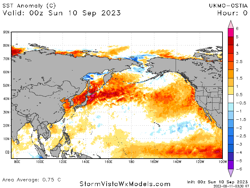
Apparently it can flip on a dime as it did in 2019-20. I guess it’s just a waiting game now at this point. CPC maps based on the cfs v2 does have the WPAC warming up into winter, maybe by a half degree or so. It’s highly unlikely that we can completely shut down the warm mjo phases, but those 30c ssts around the dateline will make 7-8-1 open for business and that’s what we want. A super nino would place forcing too far east, and that scenario is looking increasingly unlikely. Doesn’t mean that a repeat flip in the WPAC is more likely either.
-
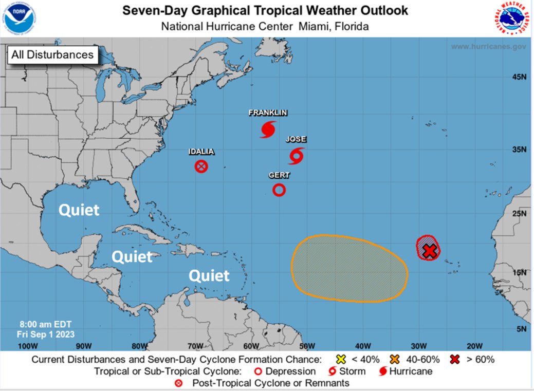
I kinda walk that comment back though, looking at quiet it is in the gulf and carribean. Activity further east and north into the Atlantic is… odd. (source: CWG) And for all the talk of the EQ WPAC pool interfering with this el nino, ssts there are pretty close to normal…
-
Did they adjust the models to bias warmer because of CC?
-
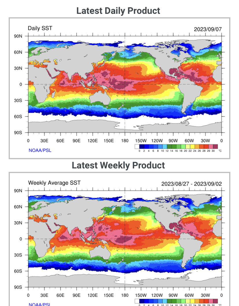
I think that can be partly explained by very cold ssts SW of CA/Baja from the record -pdo of last winter, and on the Atlantic side record sst warmth in the gulf and carribean.
-
It doesn’t. +pdo more snowfall, -pdo less. I misspoke, it’s not anticorrelated. It’s correlated. Rookie mistake on my part.
-
WPAC, while still quite warm, is cooler than the large area of warmest ssts around the dateline. That wasn’t the case up until a month or two ago, if I remember correctly, before which the WPAC was warmest.
-
Yeah that’s what I mean, I use those interchangeably
-
Worth pointing out that in my own statistical research, the PDO is most strongly anti-correlated with MA snowfall out of any SST index, including ENSO. Correction: PDO is positively correlated (not negatively correlated) with MA snowfall. My bad
-
Most statistical models had this peaking at 1.0 ONI and dynamic at 2.0 ONI. We’re already at 1.5 on the dailies/weeklies, so it’s reasonable to think that we’ll split the difference at 1.5 ONI peak. The WPAC warm pool has cooled slightly in recent weeks, so given a couple of months for the MEI to catch up, I’m fairly confident of a 1.0 MEI going into winter. There’s also time for another chance for a KW to induce further a bit more warming, but I think its pretty safe to say that super is off the table at this point.
-
I’ve had more rain in the first 9 days of september than the entire months of May and June combined. Most of it fell in 3 days.