Terpeast
-
Posts
6,687 -
Joined
-
Last visited
Content Type
Profiles
Blogs
Forums
American Weather
Media Demo
Store
Gallery
Everything posted by Terpeast
-
Bring it! Will be nice to take hour walks in the morning without dripping buckets of sweat.
-
I think I see why. Looking at the upper left of each plot, the jet is further north in the new vs old. So instead of buckling southward into western US, it goes over the top of NW Canada promoting a ridge there. Big changes downstream.
-
And part of the problem with 22-23 was the timing of those favorable patterns. They happened outside of our peak winter window. Had they occurred in Jan and Feb instead of Dec and Mar, the outcome would probably not have been a ratter like it was.
-
Agree. While I may not agree with all parts of it, it's not as hype-y as the title may suggest.
-
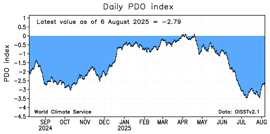
Cosigned. -PDO actually starting to reverse
-
Low of 56. Now 79/57, spectacular day for shopping at the farmers market.
-
Euro monthlies come on the 5th of every month.
-
Daily pdo from WCS: I’m watching the pdo too. Right now it’s in the gutter, but based on last year’s pattern, we still have about 2 maybe 3 months to turn it around.
-
Was checking the cfs and euro monthlies, and both show hints of AK ridging (-epo) which would lead to a winter like last season. With the QBO going negative, it might not be a bad thing. We'll see if this holds because otherwise without that AK ridging given all other factors, we may not have much of a winter to look forward to. So far there's a hint of optimism.
-
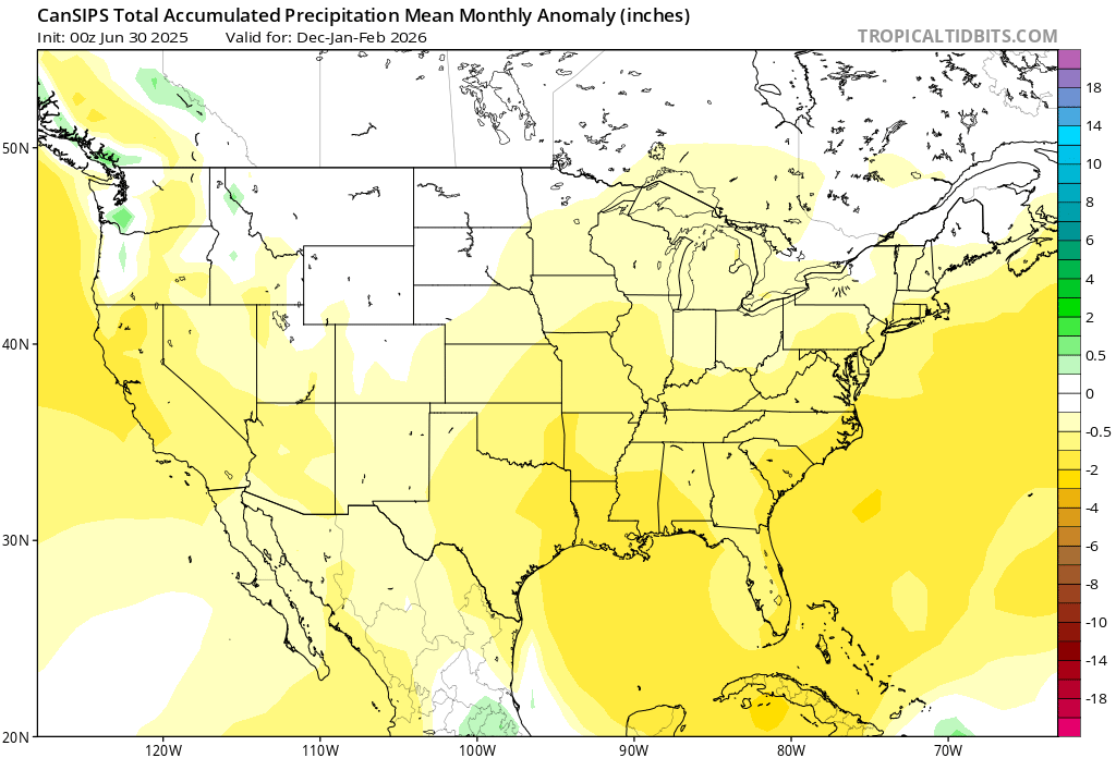
What caught my attention more than temps is this. Hard to bet on any major coastals if cansips is onto something like it was last year.

-
Sorry, Ashburn VA
-
Pouring. Lots of lightning, minimal wind. 3.40”/hr peak rain rate, 1” in 30 min
-
Narrator: Nothing happened.
-
Will be interesting to see how the outflows from the i-95 storms interact those coming out of the west.
-
Achieved 2.65”/hr rain rate under that cell passing through ashburn/brambleton. Shall see if there is more to come
-
Reached 97 for the high. Dews at 72-74
-
Much better than the heat we had last week, lower humidity. But still hot with a high of 92 and dews in the U60s/L70s
-
Total 1.13”, may get a few hundredths more per radar. But pretty happy that I didn’t have to water the garden
-
Yeah, we had a screaming STJ. Cold air just didn’t line up with it, only when it took a temporary reprieve we got snow twice from northern stream waves that trended south at the last minute.
-
0.77” so far
-
Similar forecast maps leading up to last winter. Gulf coast looks bone dry on that forecast, meaning little/no chance of miller A coastals. So like the last 2 winters, we need to get our snows from northern streamers that trend south or deamplify in short lead times.
-
Yeah as bluewave says we can look at what the mjo does in Oct to see if we get that kind of mismatch. I also think we’ll have better blocking because the qbo is negative this time, which is the main difference from last winter and from 22-23. Maybe that means we get an extra episode thrown in, and/or extend each blocking episode by a few days or so.
-
Incredible. Big hole to climb out of for this winter, it’s possible as it happened last year, but this year it may be harder.
-
Yep, that’s pretty much what he is saying. And I’m thinking the same.
-
Busted on precip, but its so refreshing out. Went for a 30 min run at 68 degrees.