

Terpeast
-
Posts
6,615 -
Joined
-
Last visited
Content Type
Profiles
Blogs
Forums
American Weather
Media Demo
Store
Gallery
Everything posted by Terpeast
-
Jan Medium/Long Range Disco: Winter is coming
Terpeast replied to stormtracker's topic in Mid Atlantic
I didn’t say that. I said we have a window of opportunity Jan 15-20/22 before looking forward to Feb -
Jan Medium/Long Range Disco: Winter is coming
Terpeast replied to stormtracker's topic in Mid Atlantic
Can’t deny the trend, but it may progress fast enough to get to p7 by Jan 25-28 give or take. Then it’s game on for Feb. let’s hope we get an opportunity in between the 15th and 22nd -
Jan Medium/Long Range Disco: Winter is coming
Terpeast replied to stormtracker's topic in Mid Atlantic
@Heisy comparing the op to ensembles is tricky because the op will change from to run, sometimes so drastically that the next run may render your analysis moot. -
Jan Medium/Long Range Disco: Winter is coming
Terpeast replied to stormtracker's topic in Mid Atlantic
That’s the time frame I’m keeping an eye on. 15-20 or so and yes @CAPE I’d be all over a 6-10” event. If we get that in January, and another storm in Feb, that could put us at climo or above. -
Jan Medium/Long Range Disco: Winter is coming
Terpeast replied to stormtracker's topic in Mid Atlantic
Update on my winter outlook for our subforum. TLDR - lowered expectations by 25% east of 15. No change west of 15. -
Terpeast's 2023-24 Winter Outlook - Overall Grade: C
Terpeast replied to Terpeast's topic in Mid Atlantic
January 6 Update - Slightly Lower Expectations in the lowlands and/or east of Route 15 While I would never cancel an El Nino winter for the mid-Atlantic, as of Jan 6, we've missed a big opportunity in the lowlands to get towards my expectations of an above-climo winter. West of route 15, however, is still very much on track and can meet or even exceed my snowfall forecast. But east of 15 in the low lands and coastal plan, we're facing an uphill battle to even reach climo. Of course we can still reach it in one big storm. The chances of 1 big KU is still higher as it's ever been. The STJ is on steroids and is as relentless as I have ever seen it. But we've lacked cold air and while we might get some more of that in the coming weeks, our window of opportunity is shrinking and fast. Especially with a projected late-Jan thaw, before a February reload with the SSWE. We NEED February to go on an absolute tear to get above climo, and if it doesn't happen, we will fall short. Maybe not in the mountains, which will still do fine, but definitely for the low lands east of 15. Sorry if my thoughts seem disorganized, I'm writing this while watching my 2 year old daughter run circles around me. She's going stir crazy. We need snow... BAD. While I'm going to officially grade myself on my original forecast, I created a new map to reflect my expectations going forward. No change west of 15, but east of 15 I'm cutting amounts by 25-30% (with an extra 20% siting penalty on DCA). Whether we reach climo at the main airport sites is now 50/50.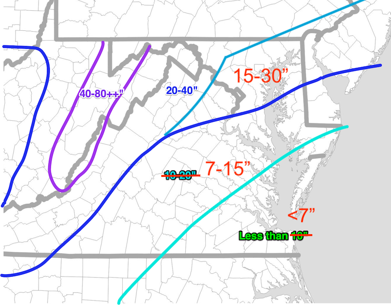
-
Jan Medium/Long Range Disco: Winter is coming
Terpeast replied to stormtracker's topic in Mid Atlantic
I was thinking about that the other day when tracking today's system. Like how I miss the times when we'd wake up to surprise snows, or when something sneaks up on us within a couple of days. -
Pouring rain here @clskinsfan hard to believe you’re only a 40 min drive west of me and you’re rippin and I’m weepin
-
Jan Medium/Long Range Disco: Winter is coming
Terpeast replied to stormtracker's topic in Mid Atlantic
The 13th wasn't supposed to be our storm though. Any wintry precip we get from that I'd call a bonus. I'm more interested in 15-20. I'm too burnt out from this weekend's storm to play the rain/snow line game for 7 days... -
Euro was the best, but it wasn't good. All models were pretty bad
-
All rain here too. Calling it 0.2” total of snow/sleet mix
-
Jan Medium/Long Range Disco: Winter is coming
Terpeast replied to stormtracker's topic in Mid Atlantic
Makes sense that there’d be a lag -
Jan Medium/Long Range Disco: Winter is coming
Terpeast replied to stormtracker's topic in Mid Atlantic
Don’t remember which phase it was, but we did get an area wide 0.5-3” here back in Dec. maybe it had nothin to do with the mjo, which I’m no expert on -
Jan Medium/Long Range Disco: Winter is coming
Terpeast replied to stormtracker's topic in Mid Atlantic
Point taken. So maybe we don’t torch during 4 and 5 this time -
Exactly. Our window of opportunity for accumulation is closing, if not already closed
-
I’m just inside that pink line on the SE. I think they’re being little too generous with that area
-
Jan Medium/Long Range Disco: Winter is coming
Terpeast replied to stormtracker's topic in Mid Atlantic
The good news in the LR is that the MJO (at least in GEFS) races through phases 4-5 within a few days to a week or so, then we should see it get back into P7 by late Jan. So maybe we get a window of opportunity between Jan 15-20, and again towards the end of the month into early feb. Plus the SSWE is actually in progress, so increased blocking throughout late Jan - Most of Feb -
Jan Medium/Long Range Disco: Winter is coming
Terpeast replied to stormtracker's topic in Mid Atlantic
Not sure what he is trying to say…? -
Mostly sleet, with some light snow mixed in Back inside enjoying hot chocolate with the wife and kid
-
Yep that lull killed us. It was all snow even under lightest returns. One flake per 10 cubic feet lol
-
I gotta say she is a bigger weenie than I am
-
Rates vanished again. Very very light snow. Most of what has fallen has already melted. I want to go back inside but my daughter doesn’t want to
-
Taking a jebwalk with the little one. Was surprised to see up to 0.2” of snow/sleet in some cooler spots.
-
Back to light moderate snow
-
By the time the heavy stuff gets here, i’d probably flip to rain


