

Terpeast
-
Posts
6,687 -
Joined
-
Last visited
Content Type
Profiles
Blogs
Forums
American Weather
Media Demo
Store
Gallery
Everything posted by Terpeast
-
Jan Medium/Long Range Disco: Winter is coming
Terpeast replied to stormtracker's topic in Mid Atlantic
Doesn’t look like much, but won’t take much to create a follow up wave along that boundary either -
Best spot for snow vacation home within 4 hours of NOVA
Terpeast replied to SnowenOutThere's topic in Mid Atlantic
Black Bear looks beautiful! Now maybe I can sell a snowy getaway to my wife on short notice if we have a storm on the way… -
It’s still unheard of for our area to go 3 years in a row without any measurable snow (over an inch) so until that actually happens, I don’t believe it will happen. But, hypothetically speaking, if we really do get nothing this season, then the truth would be clear to us. La Nina, El Nino, La Nada, +NAO, -NAO… doesn’t matter anymore. We’ll start looking at 500mb maps not for snow in our backyards, but where to chase for the weekend. My next outlook will be built for family winter vacation planning purposes.
-
Jan Medium/Long Range Disco: Winter is coming
Terpeast replied to stormtracker's topic in Mid Atlantic
The next two systems are very powerful storms, and like WW said, I don’t think there’s any way to know what happens after that until the cutters actually clear the field. Maybe we get a better idea in focus once the first one reaches SE Canada. -
Jan Medium/Long Range Disco: Winter is coming
Terpeast replied to stormtracker's topic in Mid Atlantic
Yeah, it looks suppressed this run. Not the worst problem to have at this range though -
Best spot for snow vacation home within 4 hours of NOVA
Terpeast replied to SnowenOutThere's topic in Mid Atlantic
If it weren't for the kid, I'd move there! Ok, maybe not the one with the runway in my backyard. lol -
Jan Medium/Long Range Disco: Winter is coming
Terpeast replied to stormtracker's topic in Mid Atlantic
Ok, the SLP position is fine, but I don't love the lack of a high to the north. It opens up for a cutter or app runner -
Jan Medium/Long Range Disco: Winter is coming
Terpeast replied to stormtracker's topic in Mid Atlantic
Map? If the low pressure track is the same, then what's the problem? -
Jan Medium/Long Range Disco: Winter is coming
Terpeast replied to stormtracker's topic in Mid Atlantic
I can't say conclusively because IAD data doesn't go back that far. So if I look at BWI data, that Dec 4, 1957 storm was with a high of 33 and low 29. If we warm that up by 4 degrees, we get 37/33. Maybe that 8 inches gets cut to 2-3" or becomes a mix/rain. That Jan clipper I think might still get us 1" because the cold air leading up to it was pretty cold with lows in the teens. But who knows. Feb 15-16, 1958 was a 16 inch storm for BWI with temps decreasing from 32 to 9 throughout the event. Plenty of cold before the event, too. I don't think warming this up by 4 degrees would have affected this storm if it were to happen today. March 19-20, 1958 was a 7 incher with temps between 33 and 39. Expect a rainstorm if it happened today. Don't know about IAD or points further west from IAD-BWI, might just be cold enough for wet snow in marginal situations. -
Jan Medium/Long Range Disco: Winter is coming
Terpeast replied to stormtracker's topic in Mid Atlantic
Yeah I pointed out earlier how fast the mjo wave is projected to go, and once it gets to p7 we can expect a reload of a good pattern with an aleutian low returning for late Jan into Feb brooklyn’s weeklies show this too. Some big dogs start out as a wave in the pac during mjo7 -
Jan Medium/Long Range Disco: Winter is coming
Terpeast replied to stormtracker's topic in Mid Atlantic
Op CMC may look like a turd, but look at the last 4-6 runs. It's trended better and now looks similar to the GFS. We only need them both to trend a little better and maybe a bit more suppressed at these lead times. 0z ensembles looked good on all 3 -
Jan Medium/Long Range Disco: Winter is coming
Terpeast replied to stormtracker's topic in Mid Atlantic
This is correct. The 540 height line is usually different from the 540 thickness line because of the variation of surface pressures. But if the surface pressure is exactly 1000 mb, then the 540 height is the same as the 540 thickness line, where thickness is defined as the height between the 1000mb and 500mb pressure surfaces. Usually, though, sfc pressure is a little higher than 1000 mb, so you have this extra air under the 1000-500mb layer, so the total height from surface to 500mb would be greater than 5400m… UNLESS the column is so cold that the 500mb pressure surface shrinks vertically below 5400m. Why highlight the 540dm height line? I don’t know. Seems mostly arbitrary. Or that 1000mb is the closest pressure surface to the actual surface. Someone can probably explain it better than me. Or use ChatGPT -
Jan Medium/Long Range Disco: Winter is coming
Terpeast replied to stormtracker's topic in Mid Atlantic
That’s a big shift. Makes it hard to dump the trough in the SW -
Cold SW, warm East
-
He was clearly trolling. Don’t feed him
-
Jan Medium/Long Range Disco: Winter is coming
Terpeast replied to stormtracker's topic in Mid Atlantic
Right where we want it atm -
Jan Medium/Long Range Disco: Winter is coming
Terpeast replied to stormtracker's topic in Mid Atlantic
We’re not gonna know the exact jan 16-17 track within 200 miles until the second cutter passes by -
Jan Medium/Long Range Disco: Winter is coming
Terpeast replied to stormtracker's topic in Mid Atlantic
I just checked, all ensembles/models agree on a jan 16-17 wave with varying degrees of suppression or cutter-ish looks. The ops (ec and canadian) show a cutter those days, but all ensembles show a more suppressed track which makes more sense with the block and colder air up top. The ops dump all cold air to the west making the storm cut, but I think that’s a low probability outcome that’s being over-projected by the cutter pattern this week. -
Jan Medium/Long Range Disco: Winter is coming
Terpeast replied to stormtracker's topic in Mid Atlantic
Agree. I for one would love to see a suppressed look at D7-10 lead times. And brooklyn didn’t deserve that potshot from ralph -
Jan Medium/Long Range Disco: Winter is coming
Terpeast replied to stormtracker's topic in Mid Atlantic
Either way, glad to see a better looking op run at 7 days out. That’s when the ops start to hone in on a general synoptic look and progression -
Jan Medium/Long Range Disco: Winter is coming
Terpeast replied to stormtracker's topic in Mid Atlantic
Are you still hoping jan 13 won’t be a cutter? (Serious question) -
Jan Medium/Long Range Disco: Winter is coming
Terpeast replied to stormtracker's topic in Mid Atlantic
The fact that we still have cutters this winter doesn’t concern me in the least. I predicted that we will see them half the time. Note above normal precip anomalies in the midwest from my winter outlook. Two branches of the STJ, one that cuts and one that doesn’t. This week it will be the former. But it won’t last, instead we will likely rotate between those two dominant tracks.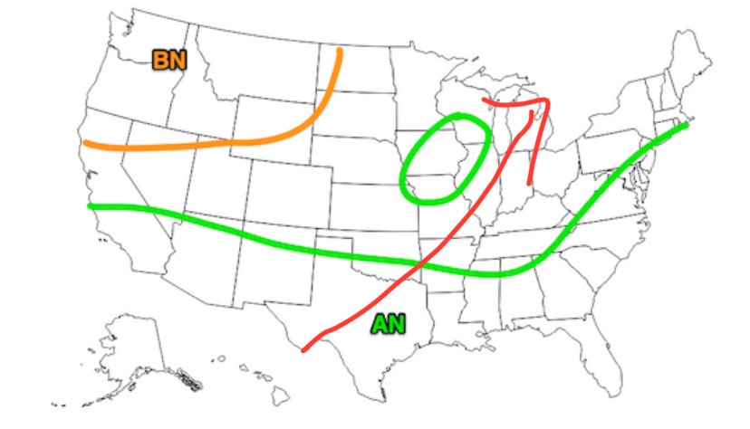
-
Jan Medium/Long Range Disco: Winter is coming
Terpeast replied to stormtracker's topic in Mid Atlantic
I didn’t say that. I said we have a window of opportunity Jan 15-20/22 before looking forward to Feb -
Jan Medium/Long Range Disco: Winter is coming
Terpeast replied to stormtracker's topic in Mid Atlantic
Can’t deny the trend, but it may progress fast enough to get to p7 by Jan 25-28 give or take. Then it’s game on for Feb. let’s hope we get an opportunity in between the 15th and 22nd -
Jan Medium/Long Range Disco: Winter is coming
Terpeast replied to stormtracker's topic in Mid Atlantic
@Heisy comparing the op to ensembles is tricky because the op will change from to run, sometimes so drastically that the next run may render your analysis moot.


