Terpeast
-
Posts
6,687 -
Joined
-
Last visited
Content Type
Profiles
Blogs
Forums
American Weather
Media Demo
Store
Gallery
Everything posted by Terpeast
-
Jan Medium/Long Range Disco 2: Total Obliteration is Coming
Terpeast replied to Jebman's topic in Mid Atlantic
We know, but we've gotten rug pulled too many times to put that superstition to bed -
Jan Medium/Long Range Disco 2: Total Obliteration is Coming
Terpeast replied to Jebman's topic in Mid Atlantic
All models have trended towards the euro except the CMC -
Jan Medium/Long Range Disco 2: Total Obliteration is Coming
Terpeast replied to Jebman's topic in Mid Atlantic
Yeah, a bit east -
Jan Medium/Long Range Disco 2: Total Obliteration is Coming
Terpeast replied to Jebman's topic in Mid Atlantic
Is that ukie trending further SE? -
Jan Medium/Long Range Disco 2: Total Obliteration is Coming
Terpeast replied to Jebman's topic in Mid Atlantic
Think if euro/gfs both agree, we can safely throw out the cmc. And euro/eps has led the way on this. Lets see if this holds today and tomorrow if I’m going to start a thread, I’d start it on Saturday after the 0z runs -
Jan Medium/Long Range Disco 2: Total Obliteration is Coming
Terpeast replied to Jebman's topic in Mid Atlantic
I don’t like the CMC solution, but it still seems unsettled with the h5 evolution. How has its performance been lately?
-
Jan Medium/Long Range Disco 2: Total Obliteration is Coming
Terpeast replied to Jebman's topic in Mid Atlantic
It would. I’m cautiously optimistic but not fully in yet. -
Jan Medium/Long Range Disco 2: Total Obliteration is Coming
Terpeast replied to Jebman's topic in Mid Atlantic
If we actually get snow cover, we may get even colder than that -
Jan Medium/Long Range Disco 2: Total Obliteration is Coming
Terpeast replied to Jebman's topic in Mid Atlantic
Liking the r/s line well south towards Richmond. Let’s hope this holds more or less the next couple of days. Good sign is that all models agree well on the cutter track up the midwest through the lakes. -
Jan Medium/Long Range Disco 2: Total Obliteration is Coming
Terpeast replied to Jebman's topic in Mid Atlantic
Even moved closer to the coast while shifting colder (12z gfs op run) -
Jan Medium/Long Range Disco 2: Total Obliteration is Coming
Terpeast replied to Jebman's topic in Mid Atlantic
Yep, its when they resolve when and how the cutter retrogrades into the tpv that we will know -
Jan Medium/Long Range Disco 2: Total Obliteration is Coming
Terpeast replied to Jebman's topic in Mid Atlantic
I think the Saturday model runs will give us a better idea for the Mon-Wed timeframe. Until then, it’s all guesswork -
Jan Medium/Long Range Disco 2: Total Obliteration is Coming
Terpeast replied to Jebman's topic in Mid Atlantic
Not a fan of how this guy makes his comparisons, but the cutter track has been highly uncertain even 48 hours out. This is why we shouldn’t bank on a certain track for 16-17 https://x.com/chasingwconnor/status/1745265130592424081?s=46&t=etSZn0BwxaYu-SKkXncW9w -
Jan Medium/Long Range Disco 2: Total Obliteration is Coming
Terpeast replied to Jebman's topic in Mid Atlantic
I was going to say the same thing. I rather be on the northern fringe at 6 days out -
Same
-
Jan Medium/Long Range Disco 2: Total Obliteration is Coming
Terpeast replied to Jebman's topic in Mid Atlantic
The big reason to consider discounting any of the solutions we’ve seen so far is that we still have to clear that second cutter before the models can zero in on a likely outcome. Until then, everything is low confidence and low skill. I don’t think the model runs tonight “failed” at all. If anything, they’ve picked up a signal that there will be a storm or two with cold air, plus some favorable trends. -
Jan Medium/Long Range Disco 2: Total Obliteration is Coming
Terpeast replied to Jebman's topic in Mid Atlantic
@baltosquidbeat me to it -
Jan Medium/Long Range Disco 2: Total Obliteration is Coming
Terpeast replied to Jebman's topic in Mid Atlantic
Gefs 4 run trend with precip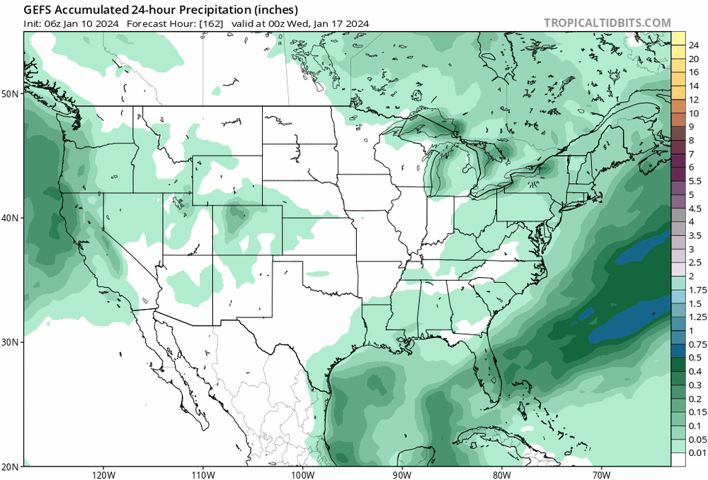
-
Jan Medium/Long Range Disco 2: Total Obliteration is Coming
Terpeast replied to Jebman's topic in Mid Atlantic
Gefs looks like 12z -
Jan Medium/Long Range Disco 2: Total Obliteration is Coming
Terpeast replied to Jebman's topic in Mid Atlantic
Lol not gonna happen that far out, and even if it did it won’t hold -
Jan Medium/Long Range Disco 2: Total Obliteration is Coming
Terpeast replied to Jebman's topic in Mid Atlantic
And its a nothing burger OTS, but that’s fine for now. Too far out for an op run -
Jan Medium/Long Range Disco 2: Total Obliteration is Coming
Terpeast replied to Jebman's topic in Mid Atlantic
Trying to set up something at 198 -
Jan Medium/Long Range Disco 2: Total Obliteration is Coming
Terpeast replied to Jebman's topic in Mid Atlantic
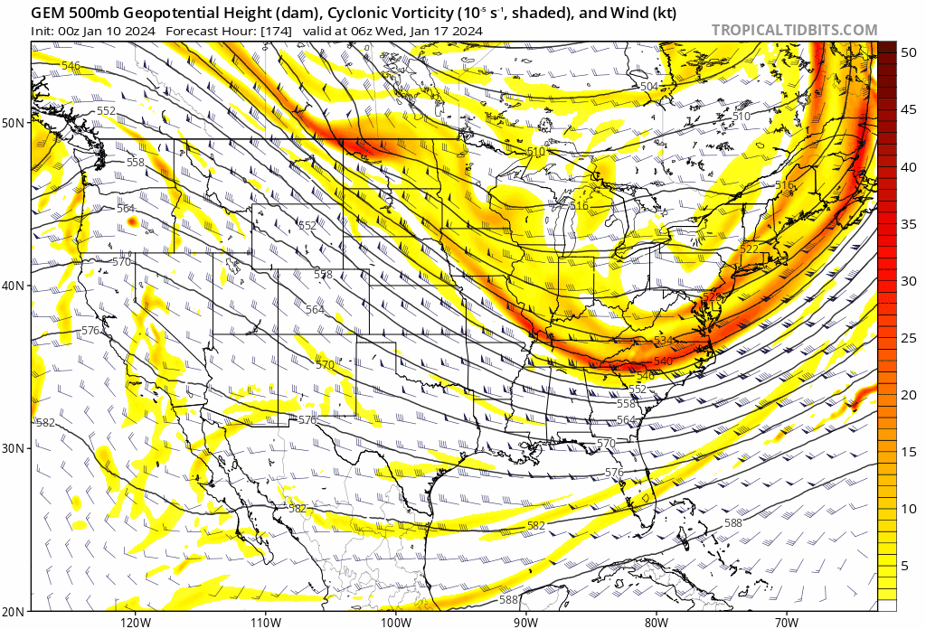
Still a ton of run to run changes, huge shifts up top at 500mb, so that tells me that the models are still resolving the details beyond the next cutter. For now these shifts are in our favor -
Jan Medium/Long Range Disco 2: Total Obliteration is Coming
Terpeast replied to Jebman's topic in Mid Atlantic
3 run trend -
Jan Medium/Long Range Disco 2: Total Obliteration is Coming
Terpeast replied to Jebman's topic in Mid Atlantic
Mostly noise out to 96 except the s/w vort is a bit slower and sharper Never mind, that wasn’t the vort of interest