Baum
-
Posts
4,523 -
Joined
-
Last visited
Content Type
Profiles
Blogs
Forums
American Weather
Media Demo
Store
Gallery
Everything posted by Baum
-
my thoughts exactly. or did you mean repeat or roll back the above average days.or both? and I guess all that is probably true.
-
I think you've seen your last rain until 2030. Plan accordingly.
-
AC unit spewing water. This early heatwave might have done it in. Wake me, when September comes.
-
I get it. But still? Last time I saw anything fall on me from a clear sky a bird had shit on me.
-
one of my pet peeves: SATURDAY NIGHT MOSTLY CLEAR WITH ISOLATED SHOWERS IN THE EVENING, FRIDAY MOSTLY SUNNY. A 20 PERCENT CHANCE OF SHOWERS AND THUNDERSTORMS IN THE AFTERNOON. can it shower from a clear sky?
-
soup du jour.
-
yup late August feel, hazy cloud cover to boot.
-
nah. Spring was this past Friday(late February/Early March), Satruday (Late March/Early April), Sunday (April), Monday (May). And yes, today begins summer.
-
I'm worried we've skipped the feel of an early summer capped heat dome and gone into a late august soup of humidity and clouds.
-
looking forward to that first morning (tomorrow) with that feel and smell of summer air, and the distinct feel of a hot and humid day. Early mornings are the best in summer particularly early summer. And even more so after the slog of cold,cloudy, rainy days we've endured. A taste of the bayou in early May...bring it.
-
fyi. rain, drizzle, cut off lows and chill can last well into june in these parts. you should know this. And your not even affected by the great lakes. Enjoy the next few days of summer as a stretch like this in early to mid may is actually an aberration. Soak in the good times when they occur.
-
^ don't get it.
-
still real early for you severe weather guys. Get the heat and dews in place and eventually there will be match to light the gas. Oddly, lost my fascination with severe with age, but emptied out every book in the library reading about tornado events and the science behind them as a kid. So take my views with a grain of salt.
-
we all know the fake warm fronts stall at I-80 in Illinois and surge north of Green Bay when the real heat hits.
-
is that the sun?
-
model hugger vs. pattern recognition. Who ya got?
-
no doubt. looking forward to it.
-

2022 Short/Medium Range Severe Weather Discussion
Baum replied to Chicago Storm's topic in Lakes/Ohio Valley
what were the rain totals in some of those storms? Heaviest rains in a 45 minute span I've seen in sometime. My decorative frog rain gauge had over 2.5" in it. But the water was flowing fast and furious through the yards. -
this goes in the holiday forecast thread. Please include a map. Thanks in advance.
-
Cloudy with only a 20% chance of showers with a high in the mid 60's.
-
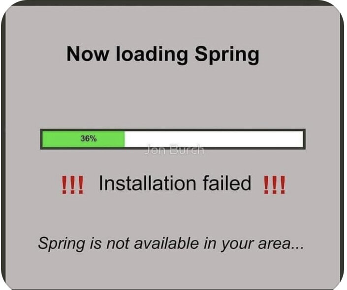
Shoot the messenger. Oddly, I think I can get more irritated waiting for consistent warmth than I do with the warm snowless starts to winter. Our spring is pretty much always like this particularly close to a 38 degree body of water. Fact is, normally you can go 150 south of us and have a dramatically different spring.
-
at this point I begin to blame the forecasters for this shit show of a spring. A non ending stream of below average, wet, windy,cloudy days. And the 7 day outlook keeps it going. I mean WTH is this from LOT:TEMPERATURES MAY ALSO BE A BIT COOLER THAN CURRENTLY FORECAST. That's in reference to Sunday's 62 degree forecast.
-
buckle up Dead Palm Guy.
-
cruel.
-