stormy
-
Posts
2,105 -
Joined
-
Last visited
Content Type
Profiles
Blogs
Forums
American Weather
Media Demo
Store
Gallery
Everything posted by stormy
-
I'll take that before brutal cold on Monday and drifting snow!!!!
-
It is odd to worry about liquid, but he is who he is. Everyone needs to understand that.
-
The 18z NAM is beginning to see..... It was totally blind to the threat on Sunday at 12z.
-
8.7 at 7 am.
-
For about 10 hours. Cheer up Mattie! At least its in the 5 day threat period.
-
I'm slightly interested. 2 identical runs are impressive.
-
11.2 this morning. At least the sun is out.
-
You are smart! Snow climo is very fluid depending on where you measure. Lets be honest, we have been in a snow drought for nearly 10 years. Micromanaging can vary.
-
I surpassed snow climo in 21-22 with 28.50 inches. The relentless harp about lack of snow and warming is amusing.................... I guess, that's what makes the world go around.....................
-
This can be a driver that often rules the roost in winter when more than -3.0 negative
-
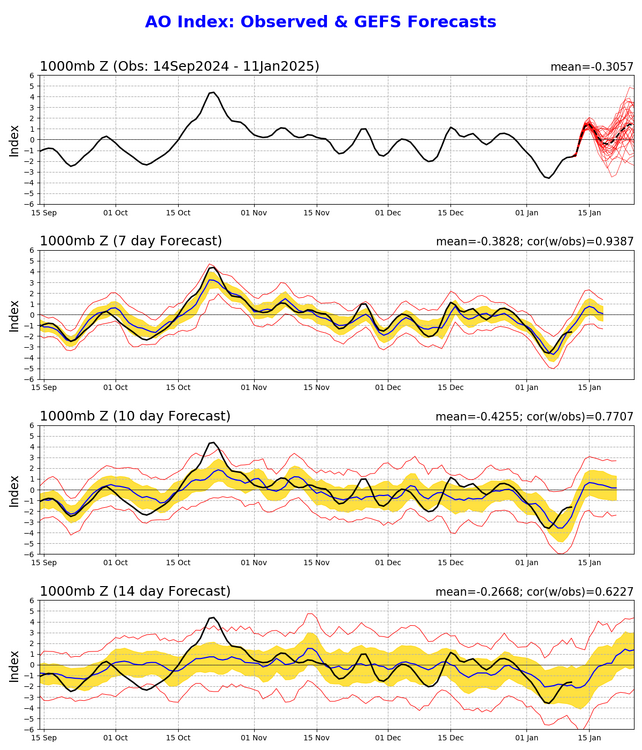
The GEFS extended has a colder anomaly for the first 10 days of February than 24 hrs. ago.
-
The EURO splits the difference between the GEM and GFS
-
GFS has the same system which is always good, but has the Atlantic ridge weaker and the system is suppressed.
-
1 inch last night. 18 at 7 am, up to 25. I plowed out the driveway because we like bare pavement.
-
Snow is very slow coming up the Valley from Roanoke.
-
I fish Douthat and Moomaw.
-
Overcast and 25 degrees at 4 pm, The latest from the HRRR indicates you might get a little more than me. How is the level of the Jackson? I fish there occasionally.
-
It takes about 50 lbs to break thru the crust. 40 lb dogs walk on top.
-
A heatwave at 23 degrees at 1:00 !!
-
1 degree at 6:30. Up to 12 at 10:30. Harrisonburg was 0 at 7 am.
-
23 degrees at 4:30 with a very cold northerly breeze of 4 - 8 mph.
-
Low of 6 after a high of 29 yesterday. Harrisonburg reported 4 this morning. 3 - 5 mph breeze hindered radiational cooling at my place. 18 at 10:45.
-
Many variables exist for the Friday/Sunday threat. Scrutiny at this point is an exercise in futility. Come back 48 hrs. from now......................
-
5.5 inches, .5" sleet and freezing rain. A 5" brick that will melt very slowly. 12 degrees this morning.
-
Heavy snow and 27.0. I inch on the board. Began at 7.