stormy
-
Posts
2,101 -
Joined
-
Last visited
Content Type
Profiles
Blogs
Forums
American Weather
Media Demo
Store
Gallery
Everything posted by stormy
-
Wind-shear and African Dust have killed the Atlantic Tropical season.
-
.11" rain yesterday and .85" for the week. Green grass abounds.
-
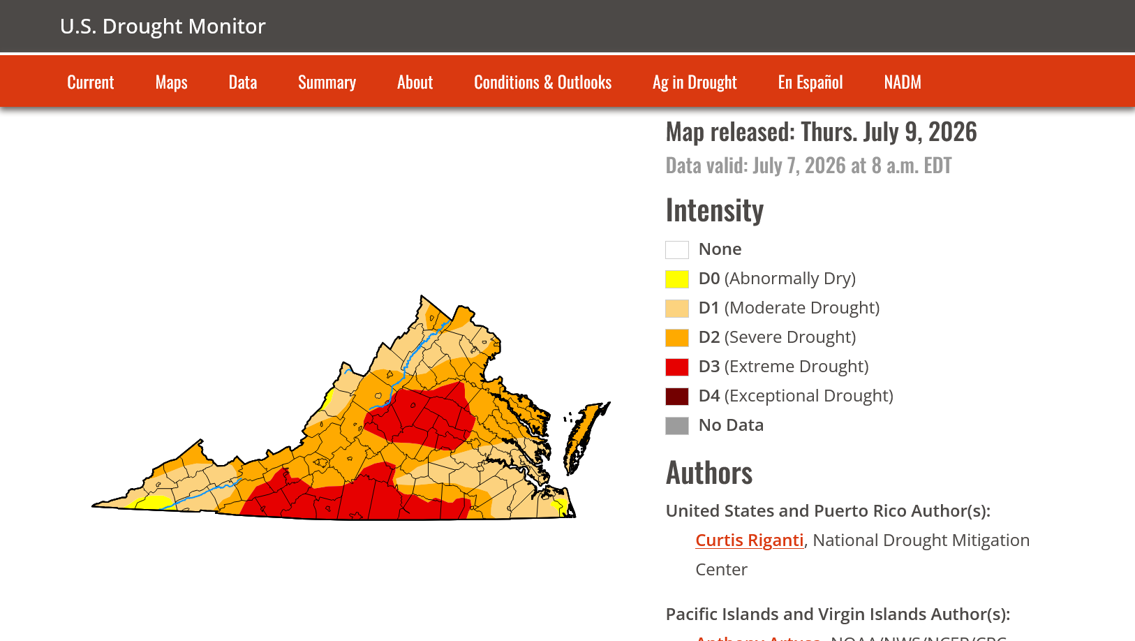
Thank you! I do appreciate your interest in this. I have followed the Drought Monitor closely for years and have had faith in its veracity until in recent months. I closely monitor water and soil conditions for some rather large agricultural interests, both topsoil and underground water table. Back in late February when our Augusta water table was 21 ft. below normal, the U.S. Drought Monitor placed Augusta in moderate drought. In late June when our water table had recovered to only 2 ft. below normal after a very wet May, the drought Monitor placed us in severe to Extreme Drought. Go figure On May 19, Augusta was all extreme. Northern Va. was all severe. On June 30, most of northern Va. down to central Rockingham had been downgraded to moderate drought. Augusta was and remains in severe to extreme. I can no longer trust the U.S. Drought Monitor as a reliable source of information.
-
Augusta County is mostly green and growing. My lawn looks quite lush and green for nearly mid July. The U.S. Drought Monitor has not changed since June 1 and keeps Augusta in Severe to Extreme Drought. Truly amazing.
-
Another .53" this late afternoon! Fishersville received 2.24..
-
I received .15 but there is a report east of New Hope of 1.18". A friend driving thru that area said ditches were full.
-
.10" yesterday evening. Staunton was under a Warning for about 30 minutes. West-side received around 2.00".
-
.75" so far. Temp. down to 70.
-
.22" more in a torrential short shower 4:05. Temperature down to 79!
-
Temp. dropped from 95 to 84 in a thundershower that dropped .07" rain.
-
68.3 after 100.3 at 5:30 yesterday.
-
The NWS had predicted a high of 95.0 for me today. Right now I am 98.9!
-
24 hrs. ago to this minute, I observed 96.0. Today at 4 pm, I observe 97. 3 The record at 100 in 1898 is safe.
-
64.8 at 6:30
-
A cooler afternoon at 96.0 at 4 pm... 24 hours ago to this minute was 97.8......
-
My low was 65.2 this morning. High yesterday was 98. A little too cool for the record which was 99 in 1959.
-
Thanks Cape, " I just tell it like it is" is a perfect description of your style. Do you believe that you may be better off not" tellin it like it is". What is wrong with a decent poster who does not tell it like it is?? A "tell it like it is bastard" is not popular with intelligent people. Why can't you allow people who you don't agree with to go on their way without a snarky attack. If they make a totally inaccurate allegation, correct it and move on without insults. And , yes, your mental issues are probably a lifelong trait
-
You need to get that thermometer in ventilated shade, all the time. This is very important.
-
LOL, I was building a case! AI makes it easy in today's world. I should tell you sometime about all the acrobatics I went thru during the late 60's to construct a temperature measuring shelter to NWS standards!!
-
I'm going by the Staunton official records. A thermometer exposed to the rays of the sun or other artificial heating can register significantly higher than actual air temperature. Even reflective heat can artificially inflate the temperature.
-
The last time we hit 100 in this area was 38 years ago on August 18, 1988. I recorded 102 on that day as I was managing a VDOT paving crew. Try that when the pavement is close to 200 out of the plant.. It will melt the soles on your shoes.
-
I was very lucky Sunday evening, receiving 1.23" between 6:30 - 8:30. Total for the weekend, 1.89"....
-
You got drawn in because I admire and greatly respect your demonstrated intelligence.
-
I am amazed at how wrong you can be about so many things!! No wonder you didn't know the difference between a Watch and a Warning! Amazing A couple other duds: Why would I be "vehemently against climate change" when it has been non-stop for millions of years! As far as "knowing more than studied meteorologists", that is hilarious!!! I like nothing more than learning from a true professional. Voretex 95 is highly intelligent and made fantastic contributions to the discussion yesterday. I only wish that he could find the time to make daily contributions. Cape? Well, he used to be contributory at times. More and more as he gets older, he gets his kicks by trying to be the bulldog on the block. Mental issues I guess. Stay straight, study hard and one day you may be a fine met. My disappointment yesterday was that several months ago, considering your desired course in life, I thought I could occasionally begin to learn from you. I just have to be patient.
-
I topped out at .66" for the event.