stormy
-
Posts
2,112 -
Joined
-
Last visited
Content Type
Profiles
Blogs
Forums
American Weather
Media Demo
Store
Gallery
Everything posted by stormy
-
A heatwave at 23 degrees at 1:00 !!
-
1 degree at 6:30. Up to 12 at 10:30. Harrisonburg was 0 at 7 am.
-
23 degrees at 4:30 with a very cold northerly breeze of 4 - 8 mph.
-
Low of 6 after a high of 29 yesterday. Harrisonburg reported 4 this morning. 3 - 5 mph breeze hindered radiational cooling at my place. 18 at 10:45.
-
Many variables exist for the Friday/Sunday threat. Scrutiny at this point is an exercise in futility. Come back 48 hrs. from now......................
-
5.5 inches, .5" sleet and freezing rain. A 5" brick that will melt very slowly. 12 degrees this morning.
-
Heavy snow and 27.0. I inch on the board. Began at 7.
-
3.7 " 12z 6.7 18z
-
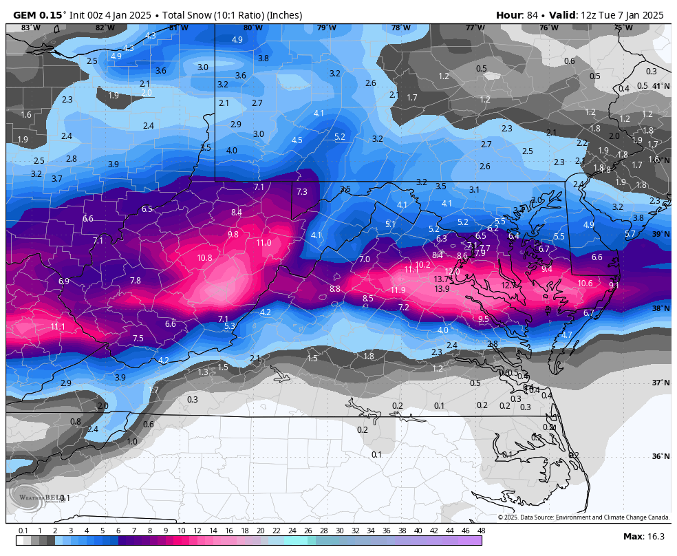
My 4 model blend is 6 inches. 4 inches GFS, 11 inches ECMWF............ 1 inch of sleet and .20 freezing rain. My call while the models are still at WAR............... 4-7 mixed with sleet and freezing rain for Augusta. 5-9 mostly snow for Winchester/D.C.
-
I agree. No blocking high to the north. Only the 50/50. Hope for the best everyone. Goodnight
-
I could clearly see a southward shift at 57, the later frames confirm it.
-
to illustrate a trend from the previous run
-
GEM south
-
You better cross your fingers. The present trend is not your friend. 12z will give the bottom line.
-
A definite southward shift in Nam at 18z. D.C. now in the bullseye.
-
The EURO and GFS are on separate islands, about 100 miles apart. The Euro and UKIE are camped on the same island.
-
I love it !! This has been my conviction for 30 hrs. now. This thing is trending north. AS I have posted since noon yesterday, mixing will be a HUGE issue ......................................
-
The ICON is what I have been trying to communicate in the last 24 hours. Accurate? Who knows
-
I dropped from 9.3 at 06z to 5.0 at 12z on the Euro. It caved toward the GEM and GFS with the southern margin. It dropped qp in my area from .95" to .69"
-
The GFS is very erratic with the movement of low pressure from western Tennessee/Kentucky to the east coast. This must be clarified with future runs to determine who gets what.
-
If the 50/50 weakens it will cut. The 06z ECM actually shifts the 50/50 slightly west and slightly increases ne confluence , hence the slight southward shift.
-
January: Medium/ Long Range: May the Force be with Us....
stormy replied to Weather Will's topic in Mid Atlantic
Like a wall! The precip. cant' get across the mountains ................................................................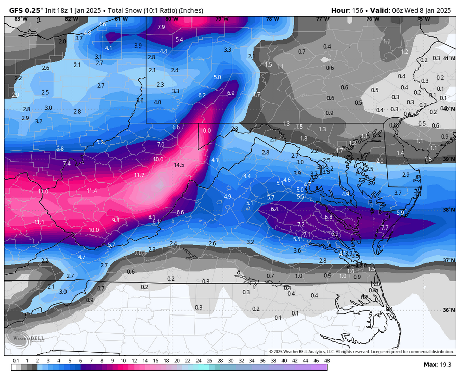
-
January: Medium/ Long Range: May the Force be with Us....
stormy replied to Weather Will's topic in Mid Atlantic
The ICON greatly diminishes Mondays potential....................... DROUGHT??................. -
January: Medium/ Long Range: May the Force be with Us....
stormy replied to Weather Will's topic in Mid Atlantic
Euro shifts north 50 - 75 miles with 12z. Not good because Miller B's are notorious for serious mixing issues. No more of this!! Get back down in Tennessee and North Carolina.